The Orphan Boy mine, also known as The Orphan, is a defunct gold and silver mine located some 12,000 feet in elevation along the Continental Divide near the town of Alma [1] [2] in Park County in central Colorado.
Discovered in 1861, the Orphan Boy was staked in 1862 and patented in 1870. The now ghost town of Sterling (not to be confused with Sterling in Logan County in northeastern Colorado) was established in 1862 to support the mines of the Mosquito Gulch area, including the Orphan Boy. Sterling soon had thirty houses, two stores, three saloons, four stamp mills to crush the ore, and a blacksmith shop. By 1865, the boom had waned, as the miners were compelled to dig deeper and found less gold to the ton but instead galena, the natural form of lead, which is often laced with silver. [3]
In later years, silver, copper, and zinc were mined too. The Orphan Boy was closed at times because of water in the tunnels, litigation, or changes in management. The town of Sterling was deserted, and in 1880 the miners mostly headed north to a strike in Montana. Fewer than a dozen miners remained behind to work the claims in Mosquito Gulch. In 1881, it was reported that the Orphan Boy and another lode, the War Eagle, had produced $500,000 worth of silver in four years of operations. A new town since discarded, Park City, emerged to replace Sterling. [3]
The Orphan Boy was owned by James Moynahan, a former Union Army veteran from Michigan. In 1903, Sheriff Silas D. Pollock forced a sale for some $21,000 to satisfy debts of the company. Thereafter, Moynahan remained as manager when the Orphan Boy came under the ownership of the Kennebec Mining Company. As early as 1879, the Orphan Boy was already considered aged. The Flume newspaper, based in the county seat of Fairplay, even called it the "old Orphan Boy mine." [3]
Meanwhile, Moynahan was from 1870 to 1873 a county commissioner. In 1876 and in 1882, he was elected to the Colorado State Senate from Park and Fremont counties. On three occasions, he was elected mayor of Alma and worked to incorporate the community. [3]
Some $7 million was taken from the Orphan Boy at a time when the price of gold never exceeded $20 per ounce. In 2013 dollars, the yield was $486 million. In 1907, the bunkhouse at the mine burned to the ground while the men were sleeping, all the men escaped with their lives. In December 2011, another fire of unknown origin destroyed the 20-foot tall ore house. All that remains of the Orphan Boy are a collapsed tool shed and the mine portal. [3]
H. Court Young has written The Orphan Boy: A Love Affair with Mining, a history of the mine and the passion of his father, geologist Herbert T. Young, one of the later owners of the Orphan Boy. [4]
Note: The H. Court Young book is about an Orphan Boy mine located in Summit County, near Montezuma and east of Keystone Ski area, and not about the one near Alma, CO.

The City of Leadville is a statutory city that is the county seat, the most populous community, and the only incorporated municipality in Lake County, Colorado, United States. The city population was 2,602 at the 2010 census and an estimated 2,762 in 2018. Leadville is situated at an elevation of 10,152 feet (3,094 m).

Alma is a Statutory Town in Park County, Colorado, United States. The town population was 296 at the 2020 United States Census. Alma is a part of the Denver-Aurora-Lakewood, CO Metropolitan Statistical Area and the Front Range Urban Corridor.

A gold rush or gold fever is a discovery of gold—sometimes accompanied by other precious metals and rare-earth minerals—that brings an onrush of miners seeking their fortune. Major gold rushes took place in the 19th century in Australia, New Zealand, Brazil, South Africa, the United States, and Canada while smaller gold rushes took place elsewhere.
Eben Smith was a successful mine owner, smelting company executive, railroad executive and bank owner in Colorado in the late 19th century and early 20th century.

The Georgia Gold Rush was the second significant gold rush in the United States and the first in Georgia, and overshadowed the previous rush in North Carolina. It started in 1829 in present-day Lumpkin County near the county seat, Dahlonega, and soon spread through the North Georgia mountains, following the Georgia Gold Belt. By the early 1840s, gold became difficult to find. Many Georgia miners moved west when gold was found in the Sierra Nevada in 1848, starting the California Gold Rush. Since the 16th century, American Indians in Georgia told European explorers that the small amounts of gold which they possessed came from mountains of the interior. Some poorly documented accounts exist of Spanish or French mining gold in North Georgia between 1560 and 1690, but they are based on supposition and on rumors passed on by Indians. In summing up known sources, W.S. Yeates observed: "Many of these accounts and traditions seem to be quite plausible. Nevertheless, it is hardly probable that the Spaniards would have abandoned mines which were afterwards found to be quite profitable, as those in North Georgia."

Ohio City is an unincorporated community and a U.S. Post Office in Gunnison County, Colorado, United States. The Ohio City Post Office has the ZIP Code 81237.

Caribou is a former silver-mining town, now a ghost town near Nederland in Boulder County, Colorado, United States. It was named after the Caribou silver mine nearby. The Caribou Ranch recording studio is several miles away, on the road from Nederland up to Caribou.
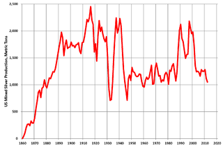
Silver mining in the United States began on a major scale with the discovery of the Comstock Lode in Nevada in 1858. The industry suffered greatly from the demonetization of silver in 1873 by the Coinage Act of 1873, known pejoratively as the "Crime of 73", but silver mining continues today.

Gold mining in Colorado, a state of the United States, has been an industry since 1858. It also played a key role in the establishment of the state of Colorado.

Oro City, now a ghost town, was an early Colorado gold placer mining town located near Leadville in the California Gulch. Oro is the Spanish word for gold. Oro City was the site of one of the single richest placer gold strikes in Colorado, with estimated gold production of 120,000 to 150,000 troy ounces, worth $2.5 to $3 million at the then-price of $20.67 per troy ounce.

The Leadville mining district, located in the Colorado Mineral Belt, was the most productive silver-mining district in the state of Colorado and hosts one of the largest lead-zinc-silver deposits in the world. Oro City, an early Colorado gold placer mining town located about a mile east of Leadville in California Gulch, was the location to one of the richest placer gold strikes in Colorado, with estimated gold production of 120,000–150,000 ozt, worth $2.5 to $3 million at the then-price of $20.67 per troy ounce.

Buckskin Joe, also called Laurette or Lauret, is a deserted ghost town in Colorado, United States. It was an early mining town, and county seat of Park County, Colorado.
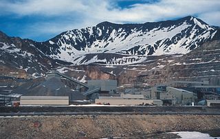
The Climax mine, located in Climax, Colorado, United States, is a major molybdenum mine in Lake and Summit counties, Colorado. Shipments from the mine began in 1915. At its highest output, the Climax mine was the largest molybdenum mine in the world, and for many years it supplied three-fourths of the world's supply of molybdenum.

The Golden Fleece Mine is a gold mining site in Hinsdale County, Colorado, 5 miles (8 km) south of Lake City. The mine is located half a mile west of the north end of Lake San Cristobal. By 1904 it had produced $1,400,000 in silver and gold ore. The mine operated intermittently until 1919. Later, in the mid-1960s, some renewed interest in the property came up, especially in the Hiwassee lode area of the mine, but other than a couple of small test shipments, there is no recorded production until today.

Confederate Gulch is a steeply incised gulch or valley on the west-facing slopes of the Big Belt Mountains in the U.S. state of Montana. Its small stream drains westward into Canyon Ferry Lake, on the upper Missouri River near present-day Townsend, Montana. In 1864, Confederate soldiers on parole during the American Civil War made a minor gold discovery in the gulch, but the discovery of the sensationally rich Montana Bar the following year—one of the richest placer strikes per acre ever made—led to other rich gold strikes up and down the gulch, and touched off a frantic boom period of placer gold mining in the area that extended through 1869. From 1866 to 1869, the gulch equaled or outstripped all other mining camps in the Montana Territory in gold production, producing an estimated $19–30 million worth of gold. For a time, Confederate Gulch was the largest community in Montana. In 1866, Montana had a total population of 28,000, and of these, about 10,000 (35%) were working in Confederate Gulch.

Chico is an unincorporated community in Park County, Montana, United States. The population of Chico was 15 as of 2010. Chico currently shares a postal ZIP code 59027 with nearby Emigrant. The community is sometimes called "Old Chico", to distinguish it from the nearby Chico Hot Springs Resort.
The Cripple Creek Gold Rush was a period of gold production in the Cripple Creek area from the late 1800s until the early 1900s. Mining exchanges were in Cripple Creek, Colorado Springs, Pueblo and Victor. Smelting was in Gillett, Florence, and (Old) Colorado City. Mining communities sprang up quickly, but most lasted only as long as gold continued to be produced. Settlements included:

The California Gulch site consists of approximately 18 square miles in Lake County, Colorado. The area includes the city of Leadville, parts of the Leadville Historic Mining District and a section of the Arkansas River from the confluence of California Gulch downstream to the confluence of Two-Bit Gulch. The site was listed as a Superfund site in 1983.
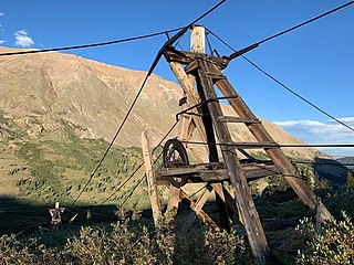
The North London Mill is a gold mill in Park County, Colorado that commenced operations in 1883. In 1874, the first London mine was opened, named for the mountain it burrowed into. The London mines became some of the most productive mines of gold, silver and lead in the area. Between 1879 and 1889, some $82,000,000 of silver was processed in the Leadville area. Colorado_Silver_BoomDue to the rugged environment and high altitude, transportation of ore between the mines and mill was difficult and costly. Thus, the first rope cable-way in Colorado was built to carry ore down the thousand-vertical-foot hill from the mine to the mill.
Lump Gulch is an area of silver and gold mines in Jefferson County in the state of Montana in the United States. It's also known as the Lump Gulch Placer and the Lump Gulch Mining District and a former mining camp called Lump Gulch City.
Coordinates: 39°16′43″N106°06′07″W / 39.27861°N 106.10194°W