
A clergy house is the residence, or former residence, of one or more priests or ministers of religion. Residences of this type can have a variety of names, such as manse, parsonage, rectory or vicarage.

Westbury is a market town and civil parish in west Wiltshire, England. The town lies below the northwestern edge of Salisbury Plain, about 4 miles (6 km) south of Trowbridge and a similar distance north of Warminster.

Dilton Marsh is a village and civil parish in the far west of the county of Wiltshire, in the southwest of England. The village is about 1.5 miles (2.4 km) southwest of the centre of the town of Westbury; Dilton Marsh remains a distinct settlement with its own character and community, bounded and separated from Westbury Leigh by the Biss Brook.

Blunham is a village and civil parish in the Central Bedfordshire district of Bedfordshire, England, about 6 miles (10 km) east of Bedford town centre. At the 2011 census date its population was 946. The River Ivel forms the parish's eastern boundary in places and the River Great Ouse its western and northern boundaries. The village is just over 0.6 miles (1 km) to the west of the A1 road, and Route 51 of the National Cycle Network passes to the south.

Aston Ingham is a village in south-eastern Herefordshire, England, near Newent and about 7 miles (11 km) east of Ross-on-Wye. The population of the village at the 2011 census was 398. There is a church, dedicated to St John the Baptist, which has been a Grade II* listed building since 17 March 1987.

Berkswell is a village and civil parish in the Metropolitan Borough of Solihull, county of West Midlands, England. Historically in Warwickshire, Berkswell is situated in the rural east of the borough, approximately 2 miles (3.2 km) west of the western city boundary of Coventry, at Eastern Green. It is situated about 6.5 miles (10.5 km) west of Coventry city centre, 8.5 miles (13.7 km) east of central Solihull, 2.5 miles (4.0 km) south of Meriden and 2 miles (3.2 km) north of Balsall Common.

Baginton is a village and civil parish in the Warwick district of Warwickshire, England, and has a common border with the City of Coventry / West Midlands county. With a population of 801, Baginton village is 4 miles (6.4 km) south of central Coventry, 4.5 miles (7.2 km) northeast of Kenilworth and 7 miles (11 km) north of Leamington Spa. The population had reduced slightly to 755 at the 2011 Census. The Lucy Price playing field is situated centrally in the village.

Colerne is a village and civil parish in north Wiltshire, England. The village is about 3.5 miles (6 km) west of the town of Corsham and 7 miles (11 km) northeast of the city of Bath. It has an elevated and exposed position, 545 feet (166 m) above sea level, and overlooks the Box valley to the south.

Cicerale is a town and comune in the province of Salerno in the Campania region of south-western Italy.

Orria is a town and comune in the province of Salerno in the Campania region of South-western Italy. As of 2011, its population was of 1161.

Prignano Cilento is a town and comune in the province of Salerno in the Campania region of south-western Italy. As of 2017 its population was of 1,035.

Stio is a town and comune in the province of Salerno in the Campania region of south-western Italy. As of 2016, its population was 872.
Old Malden is a ward of the Royal Borough of Kingston upon Thames in south London, 10 miles (16 km) south west of Charing Cross.

Noironte is a commune in the Doubs department in the Bourgogne-Franche-Comté region in eastern France.

Fifield is a village and civil parish about 4 miles (6.4 km) north of Burford in Oxfordshire. The western boundary of the parish forms part of the county boundary with Gloucestershire. The 2011 Census recorded the parish's population as 240.

Charsfield is a small Suffolk village of 342 residents, 3 miles (4.8 km) from Wickham Market, 7 miles (11 km) from Woodbridge and 12 miles (19 km) from Ipswich and is located near the villages of Debach and Dallinghoo. A civil parish in East Anglia, Charsfield was famously used as one of the key locations in the 1974 film Akenfield, based loosely upon the book Akenfield: Portrait of an English Village by Ronald Blythe (1969). Charsfield hosted the first Greenbelt festival - an annual festival of arts, faith and justice - on a pig farm just outside the village over the August 1974 bank holiday weekend.

Avant-lès-Ramerupt is a commune in the Aube department in the Grand Est region of north-central France.

Plaňany is a market town in Kolín District in the Central Bohemian Region of the Czech Republic. It has about 1,900 inhabitants.

The Alento is a river in southwestern Italy. Originating from Le Corne mountain, nearby the village of Gorga, it flows in the Campanian territory of Cilento, in the Province of Salerno. Its mouth is on the Tyrrhenian Sea, close to the Ancient Greek town of Velia, at the borders between the municipalities of Casal Velino and Ascea.

Piano Vetrale, also shortened as Vetrale or Piano, is a southern Italian village and hamlet (frazione) of Orria, a municipality in the province of Salerno, Campania. As of 2011, its population was of 475.
 St. John the Baptist Church
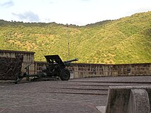 A cannon in the central square
 An old bridge near the village
 An old farmhouse near the village


