Otis, Iowa | |
|---|---|
 Otis  Otis | |
| Coordinates: 41°57′05″N91°37′24″W / 41.95139°N 91.62333°W | |
| Country | United States |
| State | Iowa |
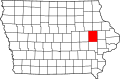
| County | Linn |
| City | Cedar Rapids |
| Elevation | 758 ft (231 m) |
| Time zone | UTC-6 (Central (CST)) |
| • Summer (DST) | UTC-5 (CDT) |
| Area code | 319 |
| GNIS feature ID | 464186 |
Otis is an unincorporated area in the city of Cedar Rapids in Linn County, Iowa, United States. [1]