| Otoro River | |
|---|---|
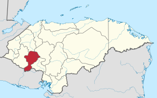
| Country | Honduras |
The Otoro River, also known as the Grande de Otoro River, is a river in Honduras which begins in the department of Intibucá and then becomes the Ulúa River in the Santa Barbara Department. [1]

Honduras, officially the Republic of Honduras, is a country in Central America. In the past, it was sometimes referred to as "Spanish Honduras" to differentiate it from British Honduras, which later became modern-day Belize. The republic of Honduras is bordered to the west by Guatemala, to the southwest by El Salvador, to the southeast by Nicaragua, to the south by the Pacific Ocean at the Gulf of Fonseca, and to the north by the Gulf of Honduras, a large inlet of the Caribbean Sea.

The Ulúa River is a river in western Honduras. It rises in the central mountainous area of the country close to La Paz and runs 240 kilometres (150 mi) approximately due northwards to the east end of the Gulf of Honduras at 15°55′N87°43′W. En route, it is joined by the Sulaco River, the Jicatuyo River, the Otoro River and the Chamelecón River.

Santa Bárbara is one of the 18 departments (departamentos) into which Honduras is divided. The departmental capital is Santa Bárbara.
One of its more famous tributaries is the Río Gualcarque. This river is the proposed site for the Agua Zarca Dam, which came to international prominence when Berta Cáceres was assassinated for her work opposing this dam.
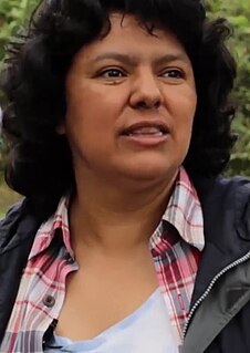
Berta Isabel Cáceres Flores (Lenca) was a Honduran environmental activist, indigenous leader, and co-founder and coordinator of the Council of Popular and Indigenous Organizations of Honduras (COPINH). She won the Goldman Environmental Prize in 2015, for "a grassroots campaign that successfully pressured the world’s largest dam builder to pull out of the Agua Zarca Dam" at the Río Gualcarque.