
Ottawa is the capital city of Canada. Located on the south bank of the Ottawa River in the southern portion of the province of Ontario, Ottawa borders Gatineau, Quebec, and forms the core of the Ottawa–Gatineau census metropolitan area (CMA) and the National Capital Region (NCR). As of 2021, Ottawa had a city population of 1,017,449 and a metropolitan population of 1,488,307, making it the fourth-largest city and fourth-largest metropolitan area in Canada.

Sussex Drive, also known as Ottawa Regional Road 93, is an arterial road in Ottawa, Ontario, the capital of Canada. It is one of the city's main ceremonial and institutional routes. Travelling roughly parallel to the Ottawa River, Sussex Drive begins as a continuation of Sir George-Étienne Cartier Parkway at Rideau Gate, at the entrance to Rideau Hall. It travels south to Rideau Street, with the portion south of St. Patrick Street forming the northbound half of a one-way pair with Mackenzie Avenue. Both Mackenzie Avenue and Sussex Drive connect with Colonel By Drive at their southern end, which continues south alongside the Rideau Canal.

The Greenbelt is a 203.5-square-kilometre (78.6 sq mi) protected green belt traversing Ottawa, Ontario, Canada. It includes green space, forests, farms, and wetlands from Shirleys Bay in the west and to Green's Creek in the east. The National Capital Commission (NCC) owns and manages 149.5 square kilometres (57.7 sq mi), and the rest is held by other federal government departments and private interests. Real estate development within the Greenbelt is strictly controlled.

Downtown Ottawa is the central area of Ottawa, Ontario, Canada. It is sometimes referred to as the Central Business District and contains Ottawa's financial district. It is bordered by the Ottawa River to the north, the Rideau Canal to the east, Gloucester Street to the south and Bronson Avenue to the west. This area and the residential neighbourhood to the south are also known locally as 'Centretown'. The total population of the area is 4,876.
Strathcona Park is a large park in Ottawa, Ontario, Canada. It lies on the west bank of the Rideau River and marks the eastern edge of the Sandy Hill neighbourhood.

The Sir John A. Macdonald Parkway, formerly the Ottawa River Parkway, is a four-lane scenic parkway along the Ottawa River in Ottawa, Ontario, Canada. It runs from Carling Avenue near Connaught Avenue, to Booth Street at the Canadian War Museum and National Holocaust Monument. It is maintained by the National Capital Commission. The speed limit is 60 km/h (37 mph). Bicycles are allowed on the road and on a parallel recreational path along the parkway.

The Hog's Back Falls, officially known as the Prince of Wales Falls, but rarely referred to by this name, are a series of artificial waterfalls on the Rideau River in Ottawa, Ontario, Canada. The falls are located just north of Mooney's Bay and the point where the Rideau Canal splits from the Rideau River.
The Pathway Patrol is a volunteer organization, managed by the City of Ottawa's City Wide Sports Department based in Ottawa, Canada. Trained volunteer patrollers cycle, in-line skate, or walk along Ottawa's recreational pathways to promote active living, improve safety and security, and to encourage courtesy among all users. Areas patrolled span the NCC pathways in the west from Andrew Haydon Park through Britannia Park, east along the Ottawa River Pathway to Petrie Island, The Rideau Canal, The Rideau River and within City of Ottawa parks in the Greenboro area. In 2010, Kanata was added to the patrol region.

Hunt Club is a community in River Ward, in the south end of Ottawa, Ontario, Canada. The area is named after the Ottawa Hunt and Golf Club, which has been part of the area since 1876. Hunt Club Road and many local businesses were also named after the golf course.
Prince of Wales on the Rideau is an affluent neighbourhood in Carleton Heights, River Ward, and Wellsmere Court in the west-end of Ottawa, Ontario, Canada. It consists of 210 homes on a peninsula between the Rideau River and Prince of Wales Drive, on the west shore of Mooney's Bay.

Mooney's Bay Park is a public park in Ottawa, Ontario, Canada on the Rideau River. Its main entrance is on Riverside Drive, opposite Ridgewood Avenue, but can also be accessed from Hog's Back Road.

Hog's Back Road is a 1 km (0.62 mi) road in Ottawa, Ontario, Canada. The road connects Meadowlands Drive and Prince of Wales Drive to Riverside Drive and Brookfield Road. The road is used as the boundary line between Mooney's Bay Park and Hog's Back Park. It goes over the dam creating Mooney's Bay and Hog's Back Falls, and continues over the Hog's Back swing bridge over the Rideau Canal, to allow taller boats navigating the canal to pass. The road also runs past the spot where the Rideau Canal separates from the Rideau River.

Confederation Heights is an area in south Ottawa, Canada, made up of mostly government buildings. It is bounded on the east by Data Centre Road, on the north and west by the Rideau River and on the south by Brookfield Road.

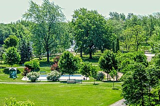
Vincent Massey Park is an urban park along the Rideau River in the Confederation Heights neighbourhood of Ottawa, Ontario, Canada, accessible via Heron Road. It is extensively used in the summer for family and group picnics.

Riverside Park is a neighbourhood in the south end of Ottawa, Canada.

This is the outline of the geography of the city of Ottawa, the capital of Canada. Ottawa's current borders were formed in 2001, when the former city of Ottawa amalgamated with the ten other municipalities within the former Regional Municipality of Ottawa–Carleton. Ottawa is now a single-tiered census division, home to 870,250 people.

The Capital Pathway, also known informally as the Bike Path, is a 220-kilometre (140 mi) recreational pathway interlinking many parks, waterways and sites in Ottawa, Ontario and Gatineau, Quebec. Most of the pathway is paved, and allows an almost continuous route through the National Capital Region.