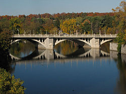
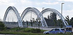
Bridge Carries Length Built Coordinates Image Remarks Bytown Bridge (West Bridge) Sussex Drive 70 m 2005 45°26′21.88″N 75°41′45.51″W / 45.4394111°N 75.6959750°W / 45.4394111; -75.6959750 Replaced the original bridge built in 1954. Bytown Bridge (East Bridge) Sussex Drive 84 m 2005 45°26′28.23″N 75°41′41.31″W / 45.4411750°N 75.6948083°W / 45.4411750; -75.6948083 Replaced the original bridge built in 1954. Minto Bridge (West Bridge) Union Street 61 m 1900 45°26′17.68″N 75°41′35.42″W / 45.4382444°N 75.6931722°W / 45.4382444; -75.6931722 Minto Bridge (East Bridge) Union Street 112 m 1900 45°26′22.93″N 75°41′31.84″W / 45.4397028°N 75.6921778°W / 45.4397028; -75.6921778 Crosses Maple Island . Island Lodge Road 92 m 1964 45°26′12.52″N 75°40′55.62″W / 45.4368111°N 75.6821167°W / 45.4368111; -75.6821167 Porter Island Bridge Pedestrian pathway (closed) 78 m 1894 45°26′12.4″N 75°40′50.48″W / 45.436778°N 75.6806889°W / 45.436778; -75.6806889 St. Patrick Street Bridge St. Patrick Street 163 m 1975 45°26′15.03″N 75°40′43.08″W / 45.4375083°N 75.6786333°W / 45.4375083; -75.6786333 Cummings Bridge Rideau Street 213 m 1921 45°25′59.58″N 75°40′16.59″W / 45.4332167°N 75.6712750°W / 45.4332167; -75.6712750 Adàwe Crossing Pedestrian pathway 125 m 2015 45°25′34.85″N 75°40′12.51″W / 45.4263472°N 75.6701417°W / 45.4263472; -75.6701417 Provincial Constable J. Robert Maki Bridge Highway 417 159 m 1955 45°25′1.19″N 75°39′46.48″W / 45.4169972°N 75.6629111°W / 45.4169972; -75.6629111 Rideau River Pedestrian/Cycling Bridge Pedestrian pathway 160 m 1909 45°24′58.86″N 75°39′46.38″W / 45.4163500°N 75.6628833°W / 45.4163500; -75.6628833 Originally carried the Canadian National Railway (1909—1966). [ 2] Hurdman Bridge O-Train Line 1 159 m 1983 45°24′51.18″N 75°40′7.05″W / 45.4142167°N 75.6686250°W / 45.4142167; -75.6686250 Originally carried the Transitway . [ 3] George McIlraith Bridge Smyth Road 240 m 1965 45°23′58.69″N 75°40′15.3″W / 45.3996361°N 75.670917°W / 45.3996361; -75.670917 [ 4] Billings Bridge Bank Street 140 m 1916 45°23′21.41″N 75°40′40.53″W / 45.3892806°N 75.6779250°W / 45.3892806; -75.6779250 George Dunbar Bridge Bronson Avenue 268 m 1996 45°22′59.79″N 75°41′19.56″W / 45.3832750°N 75.6887667°W / 45.3832750; -75.6887667 Replaced the original bridge built in 1955. Rideau River Bridge O-Train Line 2 100 m 1914 45°22′55.03″N 75°41′41.81″W / 45.3819528°N 75.6949472°W / 45.3819528; -75.6949472 Originally carried the Canadian Pacific Railway (1914—2001). Heron Road Workers Memorial Bridge Heron Road 276 m 1967 45°22′33.01″N 75°41′59.54″W / 45.3758361°N 75.6998722°W / 45.3758361; -75.6998722 Also spans the Rideau Canal . Hog's Back Fixed Bridge Hog's Back Road 69 m 1977 45°22′14.94″N 75°41′47.42″W / 45.3708167°N 75.6965056°W / 45.3708167; -75.6965056 Canadian Northern Ontario Railway Bridge Canadian National Railway 138 m 1913 45°20′44.39″N 75°41′52.09″W / 45.3456639°N 75.6978028°W / 45.3456639; -75.6978028 Originally carried the Canadian Northern Railway (1913—1923). Michael J. E. Sheflin Bridge Hunt Club Road 230 m 1985 45°20′2.86″N 75°41′46.51″W / 45.3341278°N 75.6962528°W / 45.3341278; -75.6962528 Vimy Memorial Bridge Strandherd Drive 144 m 2014 45°16′11.89″N 75°42′9.34″W / 45.2699694°N 75.7025944°W / 45.2699694; -75.7025944 Nicolls Island Road 22 m 1903 45°15′1.95″N 75°42′7.08″W / 45.2505417°N 75.7019667°W / 45.2505417; -75.7019667 The bridge structure which originally spanned the Rideau Canal was moved to Nicolls Island in 1935. [ 5] Long Island Dam Cecil Rowat Lane 48 m 1920 45°14′56.94″N 75°42′11.52″W / 45.2491500°N 75.7032000°W / 45.2491500; -75.7032000 Bridge Street (West Bridge) Bridge Street 85 m 1956 45°13′41.57″N 75°41′1.07″W / 45.2282139°N 75.6836306°W / 45.2282139; -75.6836306 Bridge Street (East Bridge) Bridge Street 108 m 1958 45°13′54.87″N 75°40′47.03″W / 45.2319083°N 75.6797306°W / 45.2319083; -75.6797306 Watson's Mill Dam Pedestrian pathway 60m 1956 45°13′37.39″N 75°40′56.68″W / 45.2270528°N 75.6824111°W / 45.2270528; -75.6824111 Replaced the original dam built in 1856. [ 6] [ 7] Roger Stevens Drive 174 m 1961 45°9′42.92″N 75°38′2.34″W / 45.1619222°N 75.6339833°W / 45.1619222; -75.6339833 Constable Hiram O'Callaghan Memorial Bridge Highway 416 290 m 1996 45°4′57.89″N 75°38′17.39″W / 45.0827472°N 75.6381639°W / 45.0827472; -75.6381639 Beckett's Landing Bridge Merlyn Wilson Road 143 m 1991 45°2′50.73″N 75°40′48.24″W / 45.0474250°N 75.6800667°W / 45.0474250; -75.6800667 Replaced the original bridge built in 1937. [ 8]