The Rideau River is a river in Eastern Ontario, Canada. The river flows north from Upper Rideau Lake and empties into the Ottawa River at the Rideau Falls in Ottawa, Ontario. Its length is 146 kilometres (91 mi).

Gloucester is a suburb in the City of Ottawa. Gloucester Township was established in 1792 and originally included lands east of the Rideau River from the Ottawa River south to Manotick. It was incorporated as a township in 1850 and became a city in 1981. Gloucester was one of the 11 municipalities that merged in 2001 to form the new city of Ottawa. As of the Canada 2016 Census, the former city of Gloucester had a population of 133,280.
Bytown is the former name of Ottawa, Ontario, Canada. It was founded on September 26, 1826, incorporated as a town on January 1, 1850, and superseded by the incorporation of the City of Ottawa on January 1, 1855. The founding was marked by a sod turning, and a letter from Governor General Dalhousie which authorized Lieutenant Colonel John By to divide up the town into lots. Bytown came about as a result of the construction of the Rideau Canal and grew largely due to the Ottawa River timber trade. Bytown's first mayor was John Scott, elected in 1847.

Rideau Street is a major street in downtown Ottawa, Ontario, Canada and one of Ottawa's oldest and most famous streets running from Wellington Street in the west to Montreal Road in the east where it connects to the Vanier district. Rideau Street is home to the Château Laurier, the CF Rideau Centre and the Government Conference Centre. Along with Wellington Street and Sussex Drive it was among the first streets in Ottawa to be host to businesses; it was created with the founding of the early town. The Plaza Bridge by the Rideau Canal is at its westmost point and the Cummings Bridge is at its eastmost point.
The Bytown and Prescott Railway (B&PR) was a railway joining Ottawa with Prescott on the Saint Lawrence River. The company was incorporated in 1850, and the first train ran from Prescott into Bytown on Christmas Day, 1854. The 84 km railway, Ottawa's first to outside markets, was initially used to ship lumber collected on the Ottawa River for further shipping along the St. Lawrence to markets in the United States and Montreal.

LeBreton Flats is a neighbourhood in Somerset Ward in central Ottawa, Ontario, Canada. It lies to the west of Centretown neighbourhood, and to the north of Centretown West. The Ottawa River forms the western and northern limit, with the western side being a wider area of the river known as Nepean Bay.

Samuel "Sam" Bingham was the Mayor of Ottawa, Ontario, Canada between 1897 and 1898.
Robert Cummings was a Canadian manufacturer and community leader.
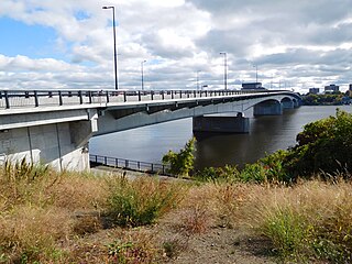
The Macdonald-Cartier Bridge is a bridge connecting Ottawa, Ontario, to Gatineau, Quebec. The bridge is a 618 m long continuous steel box girder bridge and carries six lanes of traffic. It links King Edward Avenue and Sussex Drive in Ottawa with Autoroute 5 in Quebec. It is the easternmost bridge linking Ottawa to Gatineau, running just east of the Alexandra Bridge.
Lower Town (also spelled "Lowertown" is a neighbourhood in Rideau-Vanier Ward in central Ottawa, Ontario, Canada, to the east of downtown. It is the oldest part of the city. It is bounded by Rideau Street to the south, the Ottawa River to the west and north and the Rideau River to the east. It includes the commercial Byward Market area in the south-western part, and is predominantly residential in the north and east.

The Chaudière Bridge crosses the Ottawa River about 1 km (0.6 mi) west of Parliament Hill, joining the communities of Gatineau, Quebec and Ottawa, Ontario, linking Rue Eddy in the Hull sector of Gatineau and Booth Street in Ottawa. The bridge is one portion of multiple spans constituting the Chaudière Crossing, which still contain portions of the first bridge linking Ottawa with Hull dating back to the time of Colonel By in the 1820s.
The Plaza Bridge in Ottawa, Ontario, Canada, is an automotive and pedestrian bridge that crosses the Rideau Canal just south of the Ottawa locks. It joins Wellington Street and Elgin Street in the Downtown core to the west with Rideau Street to the east. The Chateau Laurier abuts the bridge at the east end, while Parliament Hill is just beyond the west end. It is the northernmost bridge over the canal, just north of the Mackenzie King Bridge.
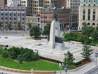
Confederation Square is an urban square in Ottawa, Ontario, Canada, and is considered the second most important ceremonial centre in Canada's capital city, after Parliament Hill. Roughly triangular in area, with Canada's National War Memorial at its centre and the Valiants Memorial at its periphery, the square is bounded by Wellington Street to the north and branches of Elgin Street to the east and west.
The history of Ottawa, capital of Canada, was shaped by events such as the construction of the Rideau Canal, the lumber industry, the choice of Ottawa as the location of Canada's capital, as well as American and European influences and interactions. By 1914, Ottawa's population had surpassed 100,000 and today it is the capital of a G7 country whose metropolitan population exceeds one million.

The Ottawa River timber trade, also known as the Ottawa Valley timber trade or Ottawa River lumber trade, was the nineteenth century production of wood products by Canada on areas of the Ottawa River and the regions of the Ottawa Valley and Western Quebec destined for British and American markets. It was the major industry of the historical colonies of Upper Canada and Lower Canada and it created an entrepreneur known as a lumber baron. The trade in squared timber and later sawed lumber led to population growth and prosperity to communities in the Ottawa Valley, especially the city of Bytown. The product was chiefly red and white pine.The Ottawa River being conveniently located with access via the St. Lawrence River, was a valuable region due to its great pine forests surpassing any others nearby. The industry lasted until around 1900 as both markets and supplies decreased, it was then reoriented to the production of wood pulp which continued until the late 1990's/early 2000's.
Ottawa Electric Railway Company was a streetcar public transit system in the city of Ottawa, Canada, part of the electric railway streetcars that operated between 1891 and 1959. Ottawa once had tracks through downtown on Rideau Street, Sparks Street and others, and extended outside of the downtown core to provide services that helped form communities such as Westboro, Old Ottawa South and The Glebe. Prior to this, starting in 1866, public transportation was provided by Ottawa City Passenger Railway Company, a horse-drawn tram service. The O.E.R. was taken over by the Ottawa Transportation Commission in 1948, which was itself succeeded by OC Transpo in 1973.

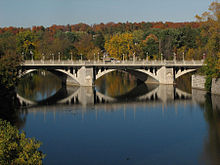
Cummings Island is an uninhabited island in the Rideau River in the city of Ottawa in Canada and the site of a former settlement.

The Adàwe Crossing is a pedestrian and cyclist bridge in Ottawa, Ontario, Canada, built across the Rideau River. It is located about 1,200 metres (1,300 yd) north (downstream) of the Highway 417 bridge and 800 metres (870 yd) south (upstream) from the Cummings Bridge. It was opened on December 4, 2015 and links the communities of Overbook and Sandy Hill.