Ottenschlag

Last updated
Ottenschlag
Ottenschlag (NO) - Ortszentrum (1).JPG
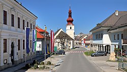
Center of Ottenschlag
AUT Ottenschlag COA.png
Coat of arms
Austria adm location map.svg
Red pog.svg
Ottenschlag
Location within Austria
Coordinates: 48°25′00″N15°13′00″E / 48.41667°N 15.21667°E / 48.41667; 15.21667 Coordinates: 48°25′00″N15°13′00″E / 48.41667°N 15.21667°E / 48.41667; 15.21667
Country Austria
State Lower Austria
District Zwettl
Government
   Mayor Christa Jager (since 2010) (ÖVP)
Area
[1]
  Total26.18 km2 (10.11 sq mi)
Elevation
849 m (2,785 ft)
Population
 (2018-01-01) [2]
  Total1,002
  Density38/km2 (99/sq mi)
Time zone UTC+1 (CET)
  Summer (DST) UTC+2 (CEST)
Postal code
3631
Area code 02872
Vehicle registration ZT
Website www.ottenschlag.com

Ottenschlag is a municipality in the district of Zwettl in the Austrian state of Lower Austria.

Population

Historical population
YearPop.±%
19711,220    
19811,202−1.5%
19911,130−6.0%
20011,102−2.5%

Related Research Articles

Wolfurt Place in Vorarlberg, Austria

Wolfurt is a municipality in the western Austrian state of Vorarlberg.

Schwarzach, Vorarlberg Place in Vorarlberg, Austria

Schwarzach is a municipality in the Austrian state of Vorarlberg.

Satteins Place in Vorarlberg, Austria

Satteins is a town in the Austrian state of Vorarlberg.

Nenzing Place in Vorarlberg, Austria

Nenzing is a market town in the district of Bludenz in the Austrian state of Vorarlberg.

Warth, Vorarlberg Place in Vorarlberg, Austria

Warth is a municipality in the district of Bregenz in the Austrian state of Vorarlberg.

Innerbraz Place in Vorarlberg, Austria

Innerbraz is a municipality in the district of Bludenz in the Austrian state of Vorarlberg.

Lorüns Place in Vorarlberg, Austria

Lorüns is a municipality in the district of Bludenz in the Austrian state of Vorarlberg.

Stallehr Place in Vorarlberg, Austria

Stallehr is a municipality in the district of Bludenz in the Austrian state of Vorarlberg.

Buch, Austria Place in Vorarlberg, Austria

Buch is a municipality in the district of Bregenz in the Austrian state of Vorarlberg.

Fußach Place in Vorarlberg, Austria

Fußach is a municipality in the district of Bregenz in the Austrian state of Vorarlberg.

Gaißau Place in Vorarlberg, Austria

Gaißau is a municipality in the district of Bregenz in the Austrian state of Vorarlberg.

Hörbranz Place in Vorarlberg, Austria

Hörbranz is a municipality in the district of Bregenz in the Austrian state of Vorarlberg.

Göfis Place in Vorarlberg, Austria

Göfis is a municipality in the district of Feldkirch in the Austrian state of Vorarlberg.

Klaus, Vorarlberg Place in Vorarlberg, Austria

Klaus is a municipality in the district of Feldkirch in the Austrian state of Vorarlberg.

Röthis Place in Vorarlberg, Austria

Röthis is a municipality in the district of Feldkirch in the Austrian state of Vorarlberg.

Sulz, Vorarlberg Place in Vorarlberg, Austria

Sulz is a municipality in the district of Feldkirch in the Austrian state of Vorarlberg.

Übersaxen Place in Vorarlberg, Austria

Übersaxen is a municipality in the district of Feldkirch in the Austrian state of Vorarlberg.

Altschwendt Place in Upper Austria, Austria

Altschwendt is a municipality in the district of Schärding in the Austrian state of Upper Austria.

Schwanenstadt Place in Upper Austria, Austria

Schwanenstadt is a town in the district of Vöcklabruck in the Austrian state of Upper Austria.

Bad Waltersdorf Place in Styria, Austria

Bad Waltersdorf is a municipality in the district of Hartberg-Fürstenfeld in Styria, Austria.

References

  1. "Dauersiedlungsraum der Gemeinden Politischen Bezirke und Bundesländer - Gebietsstand 1.1.2018". Statistics Austria. Retrieved 10 March 2019.
  2. "Einwohnerzahl 1.1.2018 nach Gemeinden mit Status, Gebietsstand 1.1.2018". Statistics Austria. Retrieved 9 March 2019.