Lake Abitibi is a shallow lake in northeastern Ontario and western Quebec, Canada. The lake, which lies within the vast Clay Belt, is separated in two distinct portions by a short narrows, making it actually 2 lakes. Its total area is 931 square kilometres (359 sq mi), and net area 903 square kilometres (349 sq mi). The lake is shallow and studded with islands. Its shores and vicinity are covered with small timber.

The Rideau River is a river in Eastern Ontario, Canada. The river flows north from Upper Rideau Lake and empties into the Ottawa River at the Rideau Falls in Ottawa, Ontario. Its length is 146 kilometres (91 mi).
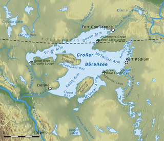
Great Bear Lake is a lake in the boreal forest of Canada. It is the largest lake entirely in Canada, the fourth-largest in North America, and the eighth-largest in the world by surface area. The lake is in the Northwest Territories, on the Arctic Circle between 65 and 67 degrees of northern latitude and between 118 and 123 degrees western longitude, 156 m (512 ft) above sea level.

The Batchawana River is a river in Algoma and Sudbury Districts of Ontario, Canada, which empties into Batchawana Bay on Lake Superior north of Sault Ste. Marie, Ontario.

The Kenogami River is a river in the James Bay drainage basin in Thunder Bay and Cochrane districts in Northern Ontario, Canada, which flows north from Long Lake near Longlac to empty into the Albany River. The river is 320 kilometres (199 mi) in length and its name means "long water" in the Cree language. A portion of the river's headwaters have been diverted into the Lake Superior drainage basin.

Opeongo Lake is a lake in the Saint Lawrence River drainage basin in the geographic townships of Bower, Dickson, Preston and Sproule in the Unorganized South Part of Nipissing District in Northeastern Ontario, Canada. It is the largest lake in Algonquin Provincial Park and the source of the Opeongo River. The lake's name comes from the Algonquian word opeauwingauk meaning "sandy narrows".
The Amable du Fond River is a river in Nipissing District, in Northern Ontario, Canada.
The Fawn River is a river in the north of the Unorganized Part of Kenora District in Northwestern Ontario, Canada. It is in the Hudson Bay drainage basin and is a right tributary of the Severn River.

Batchawana Bay is a small bay in Algoma District in Northeastern Ontario, Canada. It is on the eastern shore of Lake Superior, approximately 50 kilometres (31 mi) north of Sault Ste. Marie.

South Algonquin is a township municipality in Nipissing District, Ontario, Canada. Located south of Algonquin Provincial Park, it is the sole populated portion of the district that lies south of the traditional dividing line between Northern Ontario and Southern Ontario and is closer connected to Renfrew County as opposed to the core portions of Nipissing District.

Halfway Lake Provincial Park is a provincial park astride Ontario Highway 144 in Sudbury District in northeastern Ontario, Canada. It is operated by Ontario Parks and is named for Halfway Lake, which is entirely within the park grounds. The nearest settlement on Highway 144 is Cartier, about 25 kilometres (16 mi) to the south. The park contains more than a dozen lakes, including Antrim Lake, Bailey Lake, Benny Lake, Bittern Lake, Burnt Ridge Lake, Halfway Lake, Lodge Lake, Moosemuck Lake, Otter Lake, Raven Lake, Three Island Lake, Trapper Lake, and Two Narrows Lake. There are a mix of 221 electrical and non-electrical sites in the two campgrounds, 10 interior canoe-access sites located on Antrim Lake, Bailey Lake, and Trapper Lake, plus an additional 5 interior hike-access sites located along the Hawk Ridge Trail.
South Bentinck Arm is a 40 km (25 mi) long side-inlet of Dean Channel in the Central Coast region of British Columbia, Canada. At the north end of the arm it meets the North Bentinck Arm and then the Dean Channel before flowing into the Burke Channel.

Big Mink Lake is a fresh water lake in the St. Lawrence River drainage basin in Hastings Highlands, Hastings County, Ontario, Canada. It is about 5 kilometres (3.1 mi) west of the community of Lake St. Peter on Highway 127 and 25 kilometres (16 mi) northwest of Bancroft.

Salmon Inlet, formerly Salmon Arm, is a fjord branching east from Sechelt Inlet in the British Columbia, Canada. Its companion, Narrows Inlet, another side-inlet of Sechelt Inlet, lies roughly 10 km (6.2 mi) north. Misery and Sechelt Creeks flow freely into the inlet, while the Clowhom River flows in from the artificial Clowhom Lake, formed by a small hydroelectric power development. The fjord is 23 km (14 mi) long; Clowhom Lake, covering a waterfall on the Clowhom River, stretches a further 12 km (7.5 mi) to the western base of Mount Tantalus, which is best known from the direction of Squamish and the Cheakamus Canyon stretch of British Columbia Highway 99. Heavily affected by logging and milling operations, the inlet is split almost into two portions by an alluvial fan spreading from the mouth of Sechelt Creek.
The Black Sturgeon River is a river in the Nelson River drainage basin in Kenora District, northwestern Ontario, Canada. It is a tributary of the Winnipeg River.

Grand Lake is a lake in the Ottawa River drainage basin in the geographic townships of Barron and Stratton in the Unorganized South Part of Nipissing District in Northeastern Ontario, Canada.
The Little White River is a river in the Unorganized North Part of Algoma District in Northeastern Ontario, Canada. It is in the Great Lakes Basin and is a left tributary of the Mississagi River.
Diver is a railway point and unincorporated place in the southwest corner of geographic La Salle Township in the Unorganized North Part of Nipissing District in Northeastern Ontario, Canada. It was created during the construction of the Ontario Northland Railway in the early 20th century. Diver is located on the railway line between the dispersed rural community of Otter to the north and the railway point of Osborne to the south. It has no railway siding.

