Related Research Articles

Prunedale is a census-designated place in Monterey County, California, United States. It is located 8 miles (13 km) north of Salinas at an elevation of 92 feet (28 m). The population was 18,885 as of the 2020 census, up from 17,560 in 2010. Plum trees were grown in Prunedale in the early days of its founding, but the trees died soon after due to poor irrigation and fertilizer.
Clarence Township is a civil township located in northeast Calhoun County in the U.S. state of Michigan. It is part of the Battle Creek, Michigan Metropolitan Statistical Area. The population was 1,985 at the 2010 census. The township was originally named Pinkney Township.

Wright Township is a civil township of Hillsdale County in the U.S. state of Michigan. The population was 1,542 at the 2020 census.
Cohoctah Township is a civil township of Livingston County in the U.S. state of Michigan. The population was 3,317 at the 2010 census. It is located in the northwest quadrant of the county, bordered by Conway Township to the west, Deerfield Township to the east, and Howell Township to the south. To the north is Shiawassee County.

Frenchtown Charter Township is a charter township within Monroe County in the U.S. state of Michigan. The population was 21,609 as per the 2020 census.

Augusta Charter Township is a charter township of Washtenaw County in the U.S. state of Michigan. The population was 6,745 at the 2010 census.

Pavia Township is a township that is located in Bedford County, Pennsylvania, United States. The population was 284 at the time of the 2020 census.

Shawboro is an unincorporated community located in Currituck County, North Carolina, United States.
Mountain Park is an unincorporated community located in the Bryan Township of western Surry County, North Carolina. The community's unique name is derived from its "mountain location in a park-like setting." Notable old-time musician and luthier Johnny Gentry is from Mountain Park. The most notable event is the annual Mountain Park Independence Day Celebration that is hosted by the Mountain Park Ruritan Club, which attracts between 1,000-3,000 annually.
State Road is an unincorporated community located in the Bryan Township of Surry County, North Carolina and part of Edwards III Township in eastern Wilkes County, North Carolina, United States. As of the 2000 census, the State Road postal district (28676) had a total population of 3,047. The community's unique name is derived from its location on U.S. Route 21. Legend has it that when US 21 was first being built, locals constructed a horseshoe pit on the graded road surface. On Sunday afternoons when they got together to pitch horseshoes, they would say "let's go to state road" and the name stuck.

Bogue Banks form a 21-mile (34 km) barrier island off the mainland of North Carolina in Carteret County. The island, separated from the mainland by Bogue Sound, runs east to west, with the ocean beaches facing due south. Bogue Banks is the only island on the Carteret County shore that has been developed with housing: numerous communities are located on the island and can be accessed by one of two bridges across Bogue Sound, either from Morehead City to Atlantic Beach, which is the more heavily traveled bridge, or from Cape Carteret to Emerald Isle. The communities of Bogue Banks are the most prominent of the Crystal Coast. NC 58 traverses a majority of the island's length. There are several hotels that dot the island, but most of the land contains private houses, some of which are rented out during the summer, or maritime forest. Stores and other commercial properties are limited to the five main communities.
Wildwood is a small unincorporated community centered on the Wildwood Road, just west of the Morehead City town limits, along US Highway 70, in Carteret County, North Carolina, United States. Newport is the next closest town.
Union Cross is an unincorporated community in the Dobson Township of central Surry County, North Carolina, United States. The community is roughly centered on the intersection of Dobbins Mill Road and Twin Oaks Road. Prominent landmarks include Union Cross Baptist Church, Union Cross Baptist Church cemetery, the Dockery Family Cemetery, and a local Ruritan club. The land for the Union Cross Ruritan Club was donated to the community for this purpose by Mrs. Minnie Shinault Dockery, widow of T. Alvin Dockery, a prominent local farmer and owner of the local general store. This Community is served by the Jot-Um-Down Volunteer Fire Department, which was founded in 1980.
Ladonia is an unincorporated community located in the Franklin Township of northwest Surry County, North Carolina, United States. The community generally lies on the Fisher River and is centered on the intersection of Blevins Store Road and Ladonia Church Road. Area landmarks include Ladonia Baptist Church, M & M Signs and Awnings, and the nearby Raven Knob Scout Reservation.
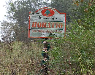
Horatio is an unincorporated community in the High Hills of Santee area in western Sumter County, South Carolina, United States.

Brownsville is an unincorporated community located in western Lower Heidelberg Township, Berks County, Pennsylvania, United States. It is located at the intersection of Brownsville and Heffner Roads. A very small portion of the village extends into North Heidelberg Township.
In North Carolina, Down East refers to two areas of Eastern North Carolina. The first is the historical group of coastal communities east of Beaufort in Carteret County. The second is anywhere east of I-95 in North Carolina in the coastal plain region.

Maple is an unincorporated community in Crawford Township, Currituck County, North Carolina, United States, located at the intersection of NC Highway 168 and SR 1246. Maple is located at latitude 36.4148780 North, and longitude -76.0040925 West. The elevation is three feet. Maple appears on the Currituck U.S. Geological Survey Map.
Bellview is an unincorporated community in Cherokee County, in the U.S. state of North Carolina. It is part of Notla Township, and is located immediately north of the Georgia border, about 10 miles south of Murphy, NC. Its average elevation is 1800 feet above sea level. U.S. Route 19 is the main highway through Bellview.
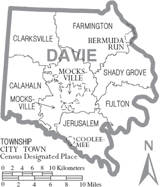
Calahaln Township is a non-functioning administrative division of Davie County, North Carolina, United States. By the requirements of the North Carolina Constitution of 1868, the counties were divided into townships, which included Calahaln township as one of sixteen townships in Davie County. Calahaln township is in western Davie County. The western border is the Iredell County line. The southern border is the South Yadkin River and Rowan County line. The northern and eastern borders are irregular and include portions of the Hunting Creek in on the southern end and Bear Creek on the northern end. The township was named for the Calahaln community, which was named for William Calahan or his descendants. William Calahan was in the area as early as 1778. Calahaln Mountain at 845 feet (258 m) is the highest point in Calahaln Township (35°55′32″N80°40′10″W.
References
- ↑ U.S. Geological Survey Geographic Names Information System: Otway, North Carolina
- ↑ "Otway, NC Introduction - Origin of Name" . Retrieved April 15, 2013.
Municipalities and communities of Carteret County, North Carolina, United States | ||
|---|---|---|
| Towns |  | |
| CDPs | ||
| Other communities | ||
| Ghost towns | ||
34°46′33″N76°33′29″W / 34.77583°N 76.55806°W