Oybin | |
|---|---|
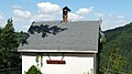
 Town hall | |
 Coat of arms | |
Location of Oybin within Görlitz district  | |
 Oybin  Oybin | |
| Coordinates: 50°50′32″N14°44′34″E / 50.84222°N 14.74278°E | |
| Country | Germany |
| State | Saxony |
| District | Görlitz |
| Municipal assoc. | Olbersdorf |
| Subdivisions | 4 Ortsteile |
| Government | |
| • Mayor (2018–25) | Tobias Steiner [1] |
| Area | |
• Total | 18.29 km2 (7.06 sq mi) |
| Elevation | 389 m (1,276 ft) |
| Population (2022-12-31) [2] | |
• Total | 1,300 |
| • Density | 71/km2 (180/sq mi) |
| Time zone | UTC+01:00 (CET) |
| • Summer (DST) | UTC+02:00 (CEST) |
| Postal codes | 02797 |
| Dialling codes | 035844 |
| Vehicle registration | GR, LÖB, NOL, NY, WSW, ZI |
| Website | www.oybin.com |
This article needs additional citations for verification .(December 2024) |
Oybin (Upper Sorbian : Ojbin, pronounced [ˈɔjbʲin] ) is a municipality in the Görlitz district, in Saxony, in eastern Germany, located very close to the border of the Czech Republic. It is a "Kurort", a resort or spa certified by the state, where people go for rest and recuperation.
Contents
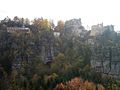
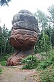
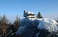
It is most famous for its mountain of the same name, an exposed natural sandstone dome that towers above the town. The ruins of a medieval monastery lend a wild romantic beauty to it and it was a favorite subject of 19th-century Romantic painters like Caspar David Friedrich. Many bizarrely shaped geological rock formations can be found in the surroundings. The scenic narrow gauge Zittau–Kurort Oybin/Kurort Jonsdorf railway runs from Oybin to Bertsdorf, from there to the neighboring municipality of Jonsdorf and the town of Zittau. Oybin municipality has 3 districts: Oybin, Hain and Lückendorf.