Related Research Articles

Ellis County is a county located in the U.S. state of Texas. As of 2019, its population was estimated to be 184,826. The county seat is Waxahachie. The county was founded in 1849 and organized the next year. It is named for Richard Ellis, president of the convention that produced the Texas Declaration of Independence.

Maypearl is a city in Ellis County, Texas, United States. The population was 934 at the 2010 census, up from 746 at the 2000 census.

White Settlement is a city in Tarrant County, Texas, United States, and a northwestern suburb of Fort Worth. The population was 17,851 in 2019.
Jeddo is an unincorporated community in Bastrop County, Texas, United States. Its elevation is 463 feet (141 m).

Pilgrim, Texas is located in Gonzales County, Texas and has a population of approximately sixty. Pilgrim is situated on land granted to Thomas J. Pilgrim by Stephen F. Austin. Pilgrim, TX is located near a salt flat, and was a notable hideout for John Wesley Hardin in the 1870s. A map shows Pilgrim is located on Farm to Market Road 1116.
Maypearl High School is a public high school located in Maypearl, Texas (USA) and classified as a 3A school by the UIL. It is part of the Maypearl Independent School District located in west central Ellis County. In 2015, the school was rated "Met Standard" by the Texas Education Agency.
Farm to Market Road 157 is a Farm to Market Road in the US state of Texas, traveling from an exit on Texas State Highway 121 south, through Euless, Bedford, Fort Worth, and Arlington in Tarrant County, then enters Johnson County, and passes through Mansfield, and Venus, before entering Ellis County, and terminating at an intersection with Farm to Market Road 66 in Maypearl. While located in Euless and Bedford, FM 157 is known as Industrial Boulevard, while in Fort Worth, it is known as Collins Street. In Arlington, the route continues on Collins, Division, and Cooper Streets. In Mansfield, the road is known as Main Street and Lone Star Road; in Venus as Main Street, 8th Street, and 7th Street; and in Maypearl as Highway 157. The highway passes directly through the center of Euless and Bedford, passing large neighborhoods and businesses. The route passes a large wetland before passing directly through downtown Arlington, passing major attractions such as AT&T Stadium and Globe Life Field. The route passes through the center of the University of Texas at Arlington, and continues through downtown and southern Arlington, before entering Mansfield. The route continues through central Mansfield, and south to Maypearl. The Texas Department of Transportation (TxDOT) designated the route in 1945, and redesignated the portion traveling from SH 121 to US Bus. 287 as Urban Road 157 from 1995 until 2018.
Smithfield is a former town in north-central Tarrant County, Texas. Located 10 miles southwest of the city of Grapevine, it was originally named Zion after the Methodist Church. A Masonic lodge and businesses existed in the city by 1876. After the donation of land for a church and cemetery, the city was renamed after donor Eli Smith who moved to the area from Missouri in 1859. Fires in 1890 and 1929 destroyed many areas of commerce in the city. However, its population remained steady through the 1930s. The city was annexed by North Richland Hills in 1958; however, Smithfield Middle School, Smithfield Elementary School and Smithfield Cemetery still carry on the name of the former town.
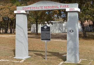
The Confederate Memorial Arch is a monument located in Cleburne, Texas in memory of the Confederacy The arch stands on the edge of the Cleburne Memorial Cemetery.

Lovelace is an unincorporated community in northwestern Hill County in Central Texas. It is located approximately eight miles north of Hillsboro, at the intersection of Texas State Highway 81 and FM 2959.
Vaughan is an unincorporated community in southern Hill County in Central Texas. It is located approximately eight miles south of Hillsboro, at the intersection of Farm Roads 1947 and 310, and roughly half a mile from Aquilla Lake.
Mountain Creek is a stream located in Johnson and Dallas counties in Texas. The community of St. Paul's once operated a cotton gin by the creek. St. Paul’s cemetery still remains close to the site where the creek flows under U.S 287 between Midlothian and Mansfield.

The Ralph Mann Homestead is a 19th-century house located in Mansfield, Texas. The building became a Recorded Texas Historic Landmark in 1977.
Soap Creek is a stream located in Ellis County, Texas.
Wardville was a former community in Johnson County, Texas that was selected as the county seat for the county in 1855.
Buchanan was a former community in Johnson County, Texas that was established as the second county seat for the county in 1856.
Cottonwood Creek is a stream primarily located in Johnson County, Texas, with parts in Ellis County.
Brazos Point is an unincorporated community in Bosque County, Texas. The community is located near the Johnson County border near the Brazos River, to the south of Nemo and Glen Rose.

Lanham Mill is a ghost town in northern Somervell County, Texas, on the bank of the White Bluff Creek, directly west of the Dinosaur Valley State Park.
Boz is an unincorporated community in Ellis County, Texas, United States. It is located on Farm Road 1493, approximately five miles southwest of Waxahachie, and to the east of Maypearl.
References
- ↑ "TSHA | Ozro, TX". www.tshaonline.org. Retrieved 2021-07-22.
- ↑ "Ozro, Texas". www.txfwgs.org. Retrieved 2021-07-22.
- ↑ "Ozro Cemetery - Texas Historical Markers on Waymarking.com". www.waymarking.com. Retrieved 2021-07-22.
- ↑ "Ozro Cemetery, Ellis Co Cemeteries of TX, Gloria B. Mayfeld". www.cemeteries-of-tx.com. Retrieved 2021-07-22.
Municipalities and communities of Ellis County, Texas, United States | ||
|---|---|---|
| Cities |  | |
| Towns | ||
| CDP | ||
| Other unincorporated communities | ||
| Footnotes | ‡This populated place also has portions in an adjacent county or counties | |
Coordinates: 32°20′15″N97°03′16″W / 32.337535°N 97.054381°W
| | This article about a location in Ellis County, Texas is a stub. You can help Wikipedia by expanding it. |