The Zulu are a Bantu ethnic group of Southern Africa and the largest ethnic group in South Africa, with an estimated 10–12 million people living mainly in the province of KwaZulu-Natal. Small numbers also live in Zimbabwe, Zambia, Tanzania and Mozambique.

The Province of Natal, commonly called Natal, was a province of South Africa from 1910 until 1994. Its capital was Pietermaritzburg. During this period rural areas inhabited by the black African population of Natal were organized into the bantustan of KwaZulu, which was progressively separated from the province, becoming partially autonomous in 1981. Of the white population, the majority were English-speaking, causing Natal to become the only province to vote "no" to the creation of a republic in the referendum of 1960. In the latter part of the 1980s, Natal was in a state of violence that only ended with the first multiracial election in 1994.
NATAL or Natal may refer to:
Kokstad is a town in the Harry Gwala District Municipality of KwaZulu-Natal Province, South Africa. Kokstad is named after the Griqua chief Adam Kok III who settled here in 1863. Stad is the Dutch and Afrikaans word for city.

KwaDukuza is a town in KwaZulu-Natal, South Africa. In 2006, its official name was changed from Stanger to KwaDukuza, but the Zulu people in the area called it "Dukuza" well before then, and many South Africans still use the name "Stanger" "Stanger" has also been used on new road signs in the area.

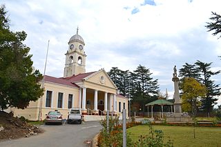
Melmoth is a small town situated in KwaZulu-Natal, South Africa. The town was established in the Mthonjaneni district after the annexation of Zululand by the United Kingdom in 1887 and was named after Sir Melmoth Osborn. Large wattle plantations were set up and a wattle bark factory was established in 1926. The district is also planted with sugar cane from the outskirts of the town and into the surrounding villages. The government-funded hospital in Melmoth is St Marys kwaMagwaza Hospital that caters for the people of Melmoth and surrounding villages.
Pinetown is a town that is part of the eThekwini Metropolitan Municipality, just inland from Durban in KwaZulu-Natal, South Africa. Pinetown is situated 16 km west of Durban at an elevation of 1,000 to 1,300 feet.
Manguzi or kwaNgwanase is a rural community in Umkhanyakude District Municipality in the KwaZulu-Natal province of South Africa. It is located some 15 km south of the Mozambique–South Africa border, and is situated near Kosi Bay.
Tugela Ferry is a town on the northern bank of the Tugela River, in central KwaZulu-Natal, South Africa. During the apartheid era it formed part of the KwaZulu homeland, and at present it is included in the Umzinyathi District Municipality. The town's name commemorates the ferry which once operated here before a steel bridge was constructed.
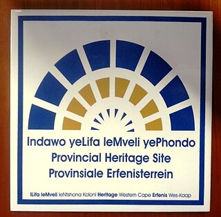
Provincial heritage sites in South Africa are places that are of historic or cultural importance within the context of the province concerned and which are for this reason declared in terms of Section 27 of the National Heritage Resources Act (NHRA) or legislation of the applicable province. The designation was a new one that came into effect with the introduction of the Act on 1 April 2000 when all former national monuments declared by the former National Monuments Council and its predecessors became provincial heritage sites as provided for in Section 58 of the Act.

Ndwedwe Local Municipality is an administrative area in the iLembe District of KwaZulu-Natal in South Africa.
Mtwalume is a settlement in Ugu District Municipality in the KwaZulu-Natal province of South Africa.
There have been a number of political assassinations in post-apartheid South Africa. In 2013 it was reported that there had been more than 450 political assassinations in the province of KwaZulu-Natal since the end of apartheid in 1994. In July 2013 the Daily Maverick reported that there had been "59 political murders in the last five years". In August 2016 it was reported that there had been at least twenty political assassinations in the run up to the local government elections on the 3rd of August that year, most of them in KwaZulu-Natal.
Amafa aKwaZulu-Natali, commonly known as 'Amafa', is a provincial heritage resources authority in terms of South Africa's National Heritage Resources Act. It was established in 1997 in terms of the KwaZulu-Natal Heritage Act of that year and is an agency of the Office of the Premier of the government of the KwaZulu-Natal Province of South Africa. It is also a 'public entity' under the terms of the Public Finance Management Act. It is mandated to care for that part of South Africa's national estate that is of provincial and local significance in KwaZulu-Natal.
Ceza is a town in Zululand District Municipality in the KwaZulu-Natal province of South Africa.
Mbongolwane is a town in Uthungulu District Municipality in the KwaZulu-Natal province of South Africa.


