Glendale is the anglicised version of the Gaelic Gleann Dail, which means valley of fertile, low-lying arable land; the name originated in Scotland.

Glendale is a city in Los Angeles County, California, United States. Its estimated 2014 population was 200,167, making it the third-largest city in Los Angeles County and the 23rd-largest city in California. It is located about 8 mi (13 km) north of downtown Los Angeles.
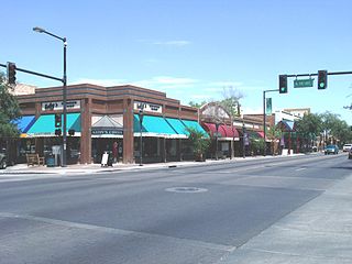
Glendale is a city in Maricopa County, Arizona, United States, located about nine miles (14 km) northwest from Downtown Phoenix. According to the 2017 U.S. Census estimates, the population of the city is 246,709.

Glendale Heights is a village in DuPage County, Illinois, United States. The population was 34,208 at the 2010 census. It is best known nationally as the hometown of Smashing Pumpkins founder Billy Corgan, but known more locally for its ethnically diverse population. The town elected Dupage County's first Asian mayor in 1995.
La Crescenta-Montrose is an unincorporated area in Los Angeles County, California. The community bordered by Glendale to the south and west, La Cañada Flintridge to the east, and Angeles National Forest to the north. According to the United States Census Bureau, the La Crescenta-Montrose CDP measures about 3.4 square miles (8.8 km2), and the population was 19,653 at the 2010 census, up from 18,532 in the 2000 census.

Glendale is a village in Hamilton County, Ohio, United States. The population was 2,155 at the 2010 census. It is site of the Glendale Historic District.
Princeton City School District is a city school district in northern Hamilton County, Ohio in the Cincinnati metropolitan area. The school district serves Glendale, Lincoln Heights, and Woodlawn; most of the cities of Sharonville, and Springdale; and parts of Blue Ash, Evendale, and Springfield Township. In addition the southeast part of Butler County's West Chester Township, the southwest corner of Warren County's Deerfield Township and the northwest corner of Sycamore Township are in the district.

Wallsend is an electoral district of the Legislative Assembly in the Australian state of New South Wales. It is currently represented by Sonia Hornery of the Labor Party.
Elysian Heights is a neighborhood within the northern Echo Park district of the city of Los Angeles, California. It is located at the eastern end of the Santa Monica Mountains.
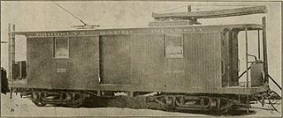
The Brooklyn Heights Railroad was a street railway company in the U.S. state of New York. It leased and operated the streetcar lines of the Brooklyn Rapid Transit Company, but started out with the Montague Street Line, a short cable car line connecting the Wall Street Ferry with downtown Brooklyn along Montague Street. Eliphalet Williams Bliss owned the railroad.

Newcastle bus routes connect suburbs in and around Newcastle and Lake Macquarie, about 100 kilometres north of Sydney.

North Avenue is a major east–west street in Chicago, Illinois, and its western suburbs. Starting at St. Charles's eastern border with West Chicago, its name changes from Main Street to North Avenue, just east of the Kane/DuPage county line. From there, it travels straight east, carrying Illinois Route 64 until LaSalle Drive in Chicago. Illinois Route 64 then continues north onto LaSalle Drive for a very short distance until ending at U.S. Route 41, while North Avenue continues east for less than one-half mile, changing its name to North Boulevard at Clark Street, and then continuing until its termination in a cul-de-sac at 200 East, just west of Lake Shore Drive. From Illinois Route 43 to its east end, North Avenue is within the city limits of Chicago.

South Park, alternatively referred to South Park–Nature Center is a station stop on the RTA Green Line in Cleveland, Ohio, USA. It is located at the intersection of South Park Boulevard and Shaker Boulevard in Shaker Heights.

Onaway is a station stop on the RTA Blue Line in Cleveland, Ohio, USA. It is located at the intersection of Onaway Road and Van Aken Boulevard in Shaker Heights.

Wyckoff Heights is an area of New York City along the Brooklyn-Queens border in northwest Bushwick and southwest Ridgewood.
Los Angeles City Council District 14 is one of the 15 districts of the Los Angeles City Council. It is a primarily Latino district in Boyle Heights and Northeast Los Angeles. Council Member Jose Huizar has represented it since 2005.
Glenside Public Library District is located at 25 East Fullerton Avenue in Glendale Heights, Illinois. It is located across the street from Americana School and shares Camera Park with Glenside Middle School.

Cloverdale is an unincorporated community in Bloomingdale Township, DuPage County, Illinois, United States. Cloverdale is located near Old Gary Avenue and Army Trail Road, near Bloomingdale.
Marquardt School District 15 is an elementary school district headquartered in Glendale Heights, Illinois. It serves sections of Glendale Heights, Addison, Bloomingdale, Glen Ellyn, and Lombard. As of 2017 it had 2,700 students.


