
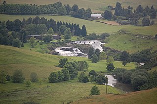
Tugela Falls is a complex of seasonal waterfalls located in the Drakensberg of Royal Natal National Park in KwaZulu-Natal Province, Republic of South Africa. It is generally accepted as the world's second-tallest waterfall but there is an argument that it is actually the tallest waterfall in the world, rather than Venezuela's Angel Falls.

The Tugela River is the largest river in KwaZulu-Natal Province, South Africa. It is one of the most important rivers of the country.

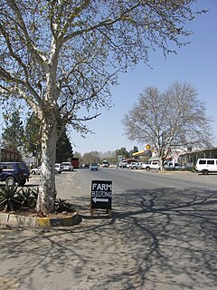
Colenso is a town in KwaZulu-Natal, South Africa. It is located on the southern bank of the Tugela River. The original settlement was contained within a loop on the river, but it subsequently expanded southwards and eastwards. It lies on the main Durban - Johannesburg railway line some 190 km (118 mi) north-west of Durban.
Winterton is a small town situated on the banks of the Tugela River in the foothills of the Drakensberg mountains, KwaZulu-Natal, South Africa. It was founded in 1905 as Springfield when the Natal Government built a weir across the Little Tugela River. The town later changed its name to Winterton in honour the secretary for agriculture, HD Winter. Winterton is a small town with only a primary school. It is close to the Second Boer War battle sites of Battle of Vaal Krantz and Spioenkop.
Kranskop is a small town that is situated on the edge of the Tugela River valley in KwaZulu-Natal, South Africa. It was founded in 1894 as Hopetown but the following confusion with another town of the same name in the Great Karoo, Northern Cape, the name was changed. Kranskop was chosen and is named after two cliff faces that rise 1,175 metres above the Tugela Valley near the town. The name is an Afrikaans word meaning "cliff head."
Tugela (USA) was a brown Thoroughbred mare. Bred by Khalid Abdullah's prominent Juddmonte Farms. Tugela was sired by Riverman and out of Rambushka who in turn was a daughter of Epsom Derby winner, Roberto, a two-time Leading sire in France.
The Amphitheatre is one of the geographical features of the Northern Drakensberg, South Africa, and is widely regarded as one of the most impressive cliff faces on earth. The cliff face of the Amphitheatre is roughly three times the size of the total combined area of all the cliff faces in Yosemite's famous El Capitan, and more than 10 times the size of El Capitan's most famous face. It is part of the Royal Natal National Park.
The Mooi River is a river in KwaZulu-Natal Province, South Africa. It rises in the Mkomazi Nature Reserve in the Drakensberg Mountains, and empties into the Tugela River near Muden. The town of Mooi River lies on the river.
1323 Tugela, provisional designation 1934 LD, is a dark background asteroid from the outer regions of the asteroid belt, approximately 60 kilometers in diameter. It was discovered on 19 May 1934, by South African astronomer Cyril Jackson at the Union Observatory in Johannesburg. The asteroid was named for the Tugela River in western South Africa.
Tugela Ferry is a town on the northern bank of the Tugela River, in central KwaZulu-Natal, South Africa. During the apartheid era it formed part of the KwaZulu homeland, and at present it is included in the Umzinyathi District Municipality. The town's name commemorates the ferry which once operated here before a steel bridge was constructed.

When the Second Boer War broke out on 11 October 1899, the Boers had a numeric superiority within Southern Africa. They quickly invaded the British territory and laid siege to Ladysmith, Kimberley and Mafeking. Britain meanwhile transported thousands of troops both from the United Kingdom itself and from elsewhere in the Empire and by the time the siege of Ladysmith had been lifted, had a huge numeric superiority.

The Royal Natal National Park is in the KwaZulu Natal province of South Africa and forms part of the uKhahlamba Drakensberg Park World Heritage Site. Notwithstanding the name, it is actually not a South African National Park managed by the SANParks, but rather a Provincial Park managed by Ezemvelo KZN Wildlife.

The Bushman's River is an east to north-easterly flowing tributary of the Tugela River, in the KwaZulu-Natal province of South Africa. It rises in the Drakensberg Mountain range, with its upper catchment in the Giant's Castle Game Reserve, north of the Giant's Castle promontory. It feeds the Wagendrift Dam and then flows past the town of Estcourt to join the Tugela River near the town of Weenen.

Precis tugela, the African leaf butterfly or eared commodore, is a butterfly of the family Nymphalidae. It is found in eastern and southern Africa, ranging from Ethiopia to South Africa. It is commonly included in the genus Precis instead of Junonia.

The Buffalo River is the largest tributary of the Tugela River in South Africa. Its source is in Majuba Hill, "Hill of Doves" in Zulu language, located northeast of Volksrust, close to the Mpumalanga / KwaZulu-Natal border. It follows a southerly route into KwaZulu-Natal past Newcastle then turns southeast past Rorke's Drift, before joining the Tugela River at Ngubevu near Nkandla. During the nineteenth century it formed part of the boundary between the Colony of Natal and Zululand.

The Wilge River is a tributary of the Vaal River in central South Africa. This river is important as part of the Tugela-Vaal Water Transfer Scheme where water is transferred from the Tugela River basin to the Vaal River basin.
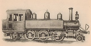
The Natal Government Railways Class I 2-6-2T of 1901 was a South African steam locomotive from the pre-Union era in the Colony of Natal.

The Natal Government Railways Class I 2-6-0 of 1902 was a South African steam locomotive from the pre-Union era in the Colony of Natal.

Tugela Commando was a light infantry regiment of the South African Army. It formed part of the South African Army Infantry Formation as well as the South African Territorial Reserve.


