Póvoa de Varzim City Hall

Last updated
Povoa de Varzim City Hall. Camara Municipal da Povoa de Varzim.jpg
Póvoa de Varzim City Hall.

Póvoa de Varzim City Hall (Portuguese: Câmara Municipal da Póvoa de Varzim) is the seat of government of the municipality of Póvoa de Varzim, Portugal. It houses the office of the mayor of Povoa de Varzim, the city council chamber, as well as other city services.

The seat of government is "the building, complex of buildings or the city from which a government exercises its authority".

Póvoa de Varzim Municipality in Norte, Portugal

Póvoa de Varzim, also spelled Povoa de Varzim, is a Portuguese city in Northern Portugal and sub-region of Greater Porto. It sits in a sandy coastal plain, a cuspate foreland, halfway between the Minho and Douro rivers. In 2001, there were 63,470 inhabitants, with 42,396 living in the city proper. The city expanded, southwards, to Vila do Conde, and there are about 100,000 inhabitants in the urban area alone. It is the seventh-largest urban agglomeration in Portugal and the third largest in Northern Portugal.

Portugal Republic in Southwestern Europe

Portugal, officially the Portuguese Republic, is a country located mostly on the Iberian Peninsula in southwestern Europe. It is the westernmost sovereign state of mainland Europe, being bordered to the west and south by the Atlantic Ocean and to the north and east by Spain. Its territory also includes the Atlantic archipelagos of the Azores and Madeira, both autonomous regions with their own regional governments.

Contents

The current building was designed by Reinald Oudinot in late 18th-century Neoclassical style and is located at Praça do Almada square in Póvoa de Varzim City Center. Póvoa's original town hall is located at Praça Velha, the late medieval core of the municipality of Póvoa de Varzim.

Neoclassical architecture is an architectural style produced by the neoclassical movement that began in the mid-18th century. In its purest form, it is a style principally derived from the architecture of classical antiquity, the Vitruvian principles, and the work of the Italian architect Andrea Palladio.

Praça do Almada

Praça do Almada is the civic center of the city of Póvoa de Varzim in Portugal, and is located in Póvoa de Varzim City Center. It contains the sculpture that pays homage to Eça de Queiroz, a notable writer who was born there.

Póvoa de Varzim City Center

Póvoa de Varzim City Center or Downtown Póvoa de Varzim is the heart of Póvoa de Varzim in Portugal, and is the location for most of the city's municipal services, tourist attractions and businesses. It is the center, not only for the city or the municipality, but also neighboring municipalities. The greater downtown area also called "Centro" can also include most districts part of Póvoa de Varzim Parish.

History

Póvoa de Varzim City Hall was part of the project for the urban rearrangement of Póvoa de Varzim in late 18th century aiming to build a new civic center and replacing an earlier town hall, during the reign of Queen Maria I.

Maria I of Portugal Portuguese monarch

Dona Maria I was Queen of Portugal from 1777 until her death. Known as Maria the Pious in Portugal and Maria the Mad in Brazil, she was the first undisputed queen regnant of Portugal and the first monarch of Brazil. With Napoleon's European conquests, her court, then under the direction of her son João, the Prince Regent, moved to Brazil, then a Portuguese colony. Later on, Brazil would be elevated from the rank of a colony to that of a kingdom, with the consequential formation of the United Kingdom of Portugal, Brazil and the Algarves.

The project was delivered by the shire's corregedor Francisco de Almada e Mendonça to the French engineer Reinaldo Ourdinot. The project started being executed in 1790-1791. The new city hall aimed to substitute the ancient and small town hall in the Old Square, insufficient for the diverse municipal departments and other functions that the ancient town hall had, the new project also took into account the considerable increase in population. [1]

Praça Velha

Praça Velha, formerly known as Praça (Square), was the primitive civic center and the market square of the city of Póvoa de Varzim in Portugal. It is located in Bairro da Matriz historic district and is surrounded by the main church of Póvoa de Varzim, the primitive Town Hall and the house of a notable 17th-century Póvoa de Varzim seafarer.

The new city hall, with its political functions beginning in 1807, was built to serve as the headquarters of the municipal powers and as a retirement home for the shire's corregedores (representatives of the royal jurisdiction). [2]

Architecture

City Hall in mid-19th century Camara municipal povoa sec19.jpg
City Hall in mid-19th century

The town hall was built between 1790 and 1791 to a design by French engineer Reinald Oudinot. The building follows the neoclassical principles of late 18th-century urbanism. [2]

The façade is solid and slightly archaic, reminding the English feitoria in Porto, which is visible in the arch stonework in the ground floor. [2] The upper floor has rectangular windows over the ground floors' arches axes. The straight platband that completes the façade is cut, at the middle, by an imposing royal coat-of-arms. In an 1868 description it was said about the building: "One of the buildings that immediately grabs the attention of the traveler, once entering the town, it is, without doubt, the town hall. It is located in a beautiful square, named do Almada, in the town centre, and it has majestic appearance". [1]

The building's present-day appearance is due to the actions of Rocha Peixoto and financial support from the Bonitos de Amorim family, a local family who got rich in Brazil, who added azulejos, in 1908–10, a work by the Belgian painter Joseph Bialman. Since 1974, the building is protected by the Portuguese national monuments institute, the IGESPAR, as a "Building of Public Importance".

Related Research Articles

Transport in Póvoa de Varzim

Póvoa de Varzim' is served by a transportation network that employs maritime, aerial and terrestrial travel. The terrestrial access infrastructure is composed of national motorways (freeways), the national roads system, and light rail metro. These infrastructures and the airport, bus terminal, marina and harbour are daily used by commuters.

Póvoa de Varzim Parish locality and former civil parish in Portugal

Póvoa de Varzim is a former Portuguese civil parish, located in the city of Póvoa de Varzim. It is the core of the city of Póvoa de Varzim and until the new city limits established in 1995 it was the single parish that made up the city. In the census of 2011, it had a population of 28,420 inhabitants and a total area of 5.25 km². A 2012 law merged the parish with neighbouring Argivai and Beiriz, becoming the southern parish of the city of Póvoa de Varzim, known as União das Freguesias da Póvoa de Varzim, Beiriz e Argivai.

Agro-Velho district of Póvoa de Varzim in Portugal

Agro-Velho, historically and popularly known as Nova Póvoa, is one of the eleven officially designated districts located in the Portuguese city of Póvoa de Varzim. It is a beach resort district located around Lagoa Cove.

Rua da Junqueira shopping street in Póvoa de Varzim City Center, Portugal

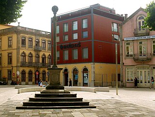
Rua da Junqueira, mostly known simply as Junqueira, is a traditional shopping street in Póvoa de Varzim in Portugal. The street, located in Póvoa de Varzim City Center, it is the main and the oldest shopping street of the city, with several boutiques, some opened for over 100 years, and small shopping centers. Historic architecture was preserved and it is also the most popular tourist area outside the beach in Póvoa de Varzim, attracting millions of visitors. It is a landmark for the city and neighboring areas.

Bairro da Matriz human settlement in Portugal

Bairro da Matriz is the historical neighbourhood of the Portuguese city of Póvoa de Varzim and part of the Matriz/Mariadeira district.

Matriz Church of Póvoa de Varzim church building in Póvoa de Varzim, Porto District, Portugal

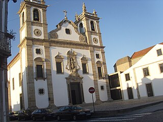
Matriz Church of Póvoa de Varzim, also Nossa Senhora da Conceição Parish Church is the Mother Roman Catholic church in Póvoa de Varzim, Portugal. The temple is located in Praça Velha square, in Bairro da Matriz quarter. The church is dedicated to the Our Lady of the Immaculate Conception, Nossa Senhora da Conceição in Portuguese, the main patron saint of Póvoa de Varzim.

Reinaldo Oudinot French engineer

Reinaldo Oudinot was a French military engineer from the 18th century, who became most famous for his hydraulic works on the Portuguese harbours of Porto, Aveiro, Leiria and Funchal. Even though he was born and educated in France, he started his career in Portugal, where he developed several projects on different fields such as: architecture, urban planning, hydraulic engineering and agriculture development. In 1803, he was to become one of the most ranked engineers on the Portuguese army as he was promoted to Brigadier of the Royal Engineers.

Praça da República (Póvoa de Varzim)

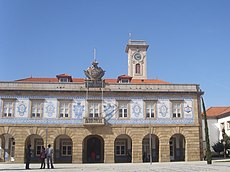
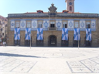
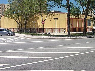
Praça da República, formerly named Largo de São Roque is a small square in the city of Póvoa de Varzim in Portugal.

Largo das Dores city square in Póvoa de Varzim, Portugal

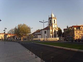
Largo das Dores or Dores Square is a square in Póvoa de Varzim city center in Portugal. Part of the earliest old town of Póvoa de Varzim, this area is listed by City Hall as heritage site. With about 11.000 square meters, its most noticeable features are its two churches, located in the sites of ancient chapels, one of which was the main church of the city.

History of Póvoa de Varzim

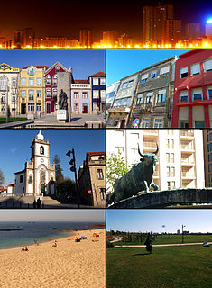
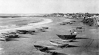
The history of Póvoa de Varzim, Portugal, and its development as a maritime trade and fishing hub, have been greatly influenced by its location at the entrance to one of Portugal's best natural ports.

Civil Parishes of Póvoa de Varzim

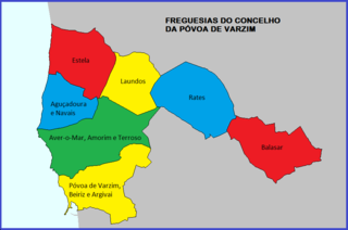
Póvoa de Varzim is divided into seven civil parishes, most of which were created as civil entities in the 19th century and some were merged in the 21st century, but are directly derived from ecclesiastical parishes existing since the Early Middle Ages. These parishes are grouped into three areas recognized by the Municipal masterplan: urban (city), suburban and rural.

Port of Póvoa de Varzim

The Port of Póvoa de Varzim is a seaport built in Enseada da Póvoa Bay in the city of Póvoa de Varzim in Portugal. During the Middle Ages, it was known as Port of Varzim.

Alminhas

Alminhas or Nichos de Alminhas do Purgatório are a type of wayside shrine typical of Póvoa de Varzim, Portugal. These small shrines are mostly urban and represent souls in Purgatory.

Póvoa de Varzim Bullfighting Arena Bullfighting arena in Norte, Portugal

Póvoa de Varzim Bullfighting Arena is a bullring in Póvoa de Varzim, Portugal. It is located in Avenida Vasco da Gama avenue, in the northern waterfront of the city. Bullfighting, horse shows, and concerts are held in the arena.

Architecture of Póvoa de Varzim

The architecture of Póvoa de Varzim, in Portugal, demonstrates a broad variety of architectural styles over its thousand years of history. 11th-century Romanesque, 16th-century Mannerism, 18th-century Baroque, late 18th-century neoclassicism, early 20th-century Portuguese modernism and late 20th- to early 21st-century contemporary architectural styles and more are all represented in Póvoa de Varzim. As a whole it represents a rich eclectic tradition and innovation shaped by the people, their beliefs and economy.

Avenida Vasco da Gama Major street in Portugal

Avenida Vasco da Gama is a street in the north central area of Póvoa de Varzim, Portugal. It is one of the main avenues in the city, with hotels, banks, sports areas, bars and is the location in the city with most high-rises. It runs from Avenida do Mar, expansion of the avenue to A28 Motorway (freeway), and Rua Gomes de Amorim to Avenida dos Banhos in the waterfront. It has some of Póvoa de Varzim's most famous landmarks such as Touro and Póvoa de Varzim Bullring.

References

  1. 1 2 Archivo pittoresco Volume XI. Castro Irmão & C.ª. 1868.
  2. 1 2 3 Amorim, Sandra Araújo (2004). Vencer o Mar, Ganhar a Terra. Na Linha do horizonte - Biblioteca Poveira CMPV.

Coordinates: 41°22′47″N8°45′36″W / 41.3796°N 8.7600°W / 41.3796; -8.7600