Geography of Póvoa de Varzim

Last updated
Satellite image of Povoa de Varzim. Cape Santo Andre is up north and Ave River in the south. The great dark spot in the middle is the Serra de Rates forest area. Povoa satelite.jpg
Satellite image of Póvoa de Varzim. Cape Santo André is up north and Ave River in the south. The great dark spot in the middle is the Serra de Rates forest area.

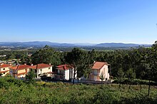
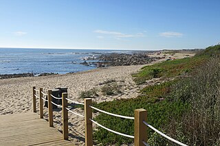
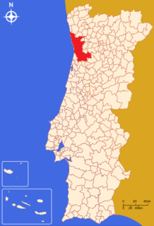
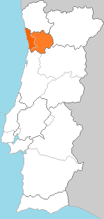
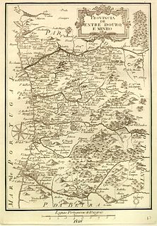
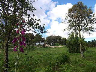
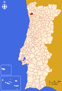
Póvoa de Varzim Coordinates: 41°22′59″N8°46′00″W / 41.38306°N 8.76667°W / 41.38306; -8.76667 , with an area of 82.06 square kilometres, lies between the Cávado and Ave Rivers, or, from a wider perspective, halfway between the Minho and Douro Rivers on the northern coast of Portugal (also known as Costa Verde - Green Coast). Although in administrative reforms of 1936, the city was integrated in Douro Litoral (with which it shares cultural and historical traditions), the case for such an administrative integration is arguable, because Póvoa de Varzim is found in a transition region (in this case, between Douro Litoral and the old province of the Minho). It has characteristic Minho traditions, historical and demographic bounds with several towns and villages in the region, religiously it is part of Braga archdiocese, [1] and due to that it is perhaps preferable to recognize Póvoa as part of the old region, favouring more Entre-Douro-e-Minho, given its central geographic position in this region.

Póvoa de Varzim Municipality in Norte, Portugal

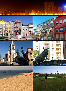
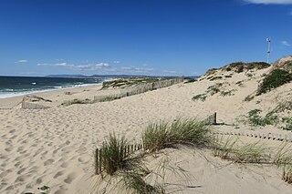
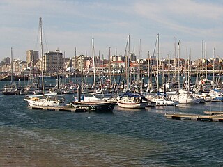
Póvoa de Varzim, also spelled Povoa de Varzim, is a Portuguese city in Northern Portugal and sub-region of Greater Porto. It sits in a sandy coastal plain, a cuspate foreland, halfway between the Minho and Douro rivers. In 2001, there were 63,470 inhabitants, with 42,396 living in the city proper. The city expanded, southwards, to Vila do Conde, and there are about 100,000 inhabitants in the urban area alone. It is the seventh-largest urban agglomeration in Portugal and the third largest in Northern Portugal.

Geographic coordinate system Coordinate system

A geographic coordinate system is a coordinate system that enables every location on Earth to be specified by a set of numbers, letters or symbols. The coordinates are often chosen such that one of the numbers represents a vertical position and two or three of the numbers represent a horizontal position; alternatively, a geographic position may be expressed in a combined three-dimensional Cartesian vector. A common choice of coordinates is latitude, longitude and elevation. To specify a location on a plane requires a map projection.

Cávado River river in Portugal

The Cávado River is a river located in northern Portugal.

Contents

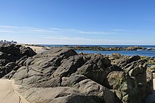
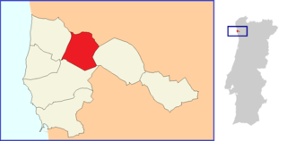
The city is limited to the north by the municipality of Esposende, to the northeast by Barcelos, to the east by Vila Nova de Famalicão, and to the south by Vila do Conde. To the west, it has a shoreline on the Atlantic Ocean. [1]

Esposende Municipality in Norte, Portugal

Esposende is a city and a municipality in Braga District in Portugal. The population in 2011 was 34,254, in an area of 95.41 km². The city itself had a population of 9,197 in 2001. It gained city status on 2 July 1993. The present Mayor is Fernando Couto Cepa, elected by the Social Democratic Party. The municipal holiday is August 19. It is located on the Portuguese Way of the Camino de Santiago.

Vila Nova de Famalicão Municipality in Norte, Portugal

Vila Nova de Famalicão is a town and municipality in the district of Braga, in the north of Portugal. The population in 2011 was 133,832, in an area of 201.59 km².

Vila do Conde Municipality in Norte, Portugal

Vila do Conde is a municipality in the Norte Region of Portugal. The population in 2011 was 79,533, in an area of 149.03 km². The urbanized area of Vila do Conde, which includes the parishes of Vila do Conde, Azurara and Árvore, represent 36,137 inhabitants. Vila do Conde is interlinked to the north with Póvoa de Varzim, forming a single urban agglomeration. The town is on the Portuguese Way of the Camino de Santiago.

Physical geography

The Primary Dune System of Povoa de Varzim as seen from Rio Alto estuary. This area extends from Rio Alto rivulet to Cape Santo Andre in the Northwestern coast of Povoa de Varzim for an extension of over 6 kilometers; 20,000 feet. Beachfront construction, erosion and, historically, agriculture are its major threats. Primary Dune system Povoa de Varzim crop.jpg
The Primary Dune System of Póvoa de Varzim as seen from Rio Alto estuary. This area extends from Rio Alto rivulet to Cape Santo André in the Northwestern coast of Póvoa de Varzim for an extension of over 6 kilometers; 20,000 feet. Beachfront construction, erosion and, historically, agriculture are its major threats.
The coastal plain. The city and its suburbs are surrounded by bouca forests. CoastalPlain Povoa Varzim.jpg
The coastal plain. The city and its suburbs are surrounded by bouça forests.
The green inland hills has higher pluviosity and lower maritime influence. Inland Povoa de Varzim.jpg
The green inland hills has higher pluviosity and lower maritime influence.

The rocky cliffs, common features down from the estuary of Minho River, disappear in Póvoa de Varzim giving way to a coastal plain.

Cliff A vertical, or near vertical, rock face of substantial height

In geography and geology, a cliff is a vertical, or nearly vertical, rock exposure. Cliffs are formed as erosion landforms by the processes of weathering and erosion. Cliffs are common on coasts, in mountainous areas, escarpments and along rivers. Cliffs are usually formed by rock that is resistant to weathering and erosion. Sedimentary rocks most likely to form cliffs include sandstone, limestone, chalk, and dolomite. Igneous rocks such as granite and basalt also often form cliffs.

The plain originates from an old marine plateau conferring a sandy soil to the lands that cross the coasts of the parishes of Póvoa, A Ver-o-Mar, Navais to Aguçadoura and Estela, and forming sand dunes, mainly in Northern Aguçadoura. [2]

Wandering along the coast one discerns Cape Santo André which is, possibly, the Avarus Promontory referred by Ptolemy, geographer of Ancient Greece, in the territory of the Callaici. [2]

Cape Santo André

Cape Santo André is a cape located in the Northern coast of continental Portugal, in Santo André, municipality of Póvoa de Varzim. It is the tip of Póvoa de Varzim's cuspate foreland.

Ptolemy 2nd-century Greco-Egyptian writer and astronomer

Claudius Ptolemy was a Greco-Roman mathematician, astronomer, geographer and astrologer. He lived in the city of Alexandria in the Roman province of Egypt, wrote in Koine Greek, and held Roman citizenship. The 14th-century astronomer Theodore Meliteniotes gave his birthplace as the prominent Greek city Ptolemais Hermiou in the Thebaid. This attestation is quite late, however, and, according to Gerald Toomer, the translator of his Almagest into English, there is no reason to suppose he ever lived anywhere other than Alexandria. He died there around AD 168.

Ancient Greece Civilization belonging to an early period of Greek history

Ancient Greece was a civilization belonging to a period of Greek history from the Greek Dark Ages of the 12th–9th centuries BC to the end of antiquity. Immediately following this period was the beginning of the Early Middle Ages and the Byzantine era. Roughly three centuries after the Late Bronze Age collapse of Mycenaean Greece, Greek urban poleis began to form in the 8th century BC, ushering in the Archaic period and colonization of the Mediterranean Basin. This was followed by the period of Classical Greece, an era that began with the Greco-Persian Wars, lasting from the 5th to 4th centuries BC. Due to the conquests by Alexander the Great of Macedon, Hellenistic civilization flourished from Central Asia to the western end of the Mediterranean Sea. The Hellenistic period came to an end with the conquests and annexations of the eastern Mediterranean world by the Roman Republic, which established the Roman province of Macedonia in Roman Greece, and later the province of Achaea during the Roman Empire.

The municipality is of 190 meters (620 feet) above sea-level. The peak of Saint Félix (202 meters; 663 feet) and of Cividade (155 m; 509 ft) are easily visible rising above the landscape. [2] Despite the modest rise, the expanse of the plain makes these easy reference points on the horizon. The mountain chain known as Serra de Rates divides the municipality in two distinctive areas: the coastal plain gives way to hills where the forests become more abundant and the soils have less sea influence. In this landscape dominated by the plain and low hills, only the hill of Corga da Soalheira (150 m; 490 ft), in the interior, is easily recognizable. [2]

Imprisoned between the sea and the mountain range, the city dominates the coastal plain. In the south, there is urban continuity with Vila do Conde, another city and municipality, establishing itself as the southern limit.

The hydrography of the municipality has no large rivers, but abundant small water courses exist due to the relief of the coastal plain. [3]

Some of these water courses are permanent, such the Este River, which feeds into the Ave River. The Esteiro River's source is at the base of Mount Cividade and it empties at the beach of Aver-o-Mar while the Alto River's source is at the base of Mount São Félix and it reaches the Atlantic at Rio Alto Beach. The land is well irrigated, the appearance of springs and wells are very common, given that, often, underground water is close to the surface. [3]

Climate

The region possesses a local microclimate, being privileged that it is considered the region least subject to frosts in all Northern Portugal due to the winter winds that, normally, blow from South and Southwest. [3]

North winds (known as Nortadas) arise, typically, in the summer after midday [3] and like the summer fogs, these refresh the air and are characteristic of Póvoa - a climate that is classified as maritime temperate. The municipality has gentle summers and mild winters, with average temperatures oscillating between 12.5 and 15 degrees Celsius. [3] The annual precipitation varies between 1200 and 1400 mm. [3]

Environment

Granitic gneiss. The gneiss forms headlands and islets which submerge during high tide. It is a biologically rich environment with diverse habitats. Praia Quiao Pescador.jpg
Granitic gneiss. The gneiss forms headlands and islets which submerge during high tide. It is a biologically rich environment with diverse habitats.

The forest areas suffer from strong demographic pressure and intensive agriculture. Forests are still important in parishes surrounded by the Serra de Rates, whose flora is distinguished by the Pedunculate Oak or the European Holly. In the 18th century, the monks of Tibães planted pinewood, which today characterizes the civil parish of Estela. In the past the Atlantic forest predominated, with trees from medium to great size, such as oaks, ash trees, hazels, strawberry trees, holm oak, and alders. [3]

The rocks throughout the entire coastline are the true fisheries of clams, fish and seaweed. These rocks and the dunes are ecosystems that possess an important ecological wealth, but are threatened by holiday-makers, dune-based sports and coastal constructions.

Póvoa de Varzim and other cities of the Greater Porto area have a strategical environment plan for Greater Porto - the Futuro Sustentável ("Sustainable Future") - which plans to understand the problems, and to create solutions and new environmental projects for Greater Porto that meet the desires of its citizens.

Beyond the urban areas, the City Park (800,000 m²) will be extended from the A28 motorway and Pedreira Lagoon will have densely forested areas, open spaces, hills, a new lake and sports area (with exception of the sports area, the project is still a proposal). The Anjo’s Urban Green, of environmental importance to the city - given that it is a native woodland area with pedunculate oaks, will be complemented by a rural park in the near future.


Related Research Articles

Metropolitan Area of Porto Place

Porto Metropolitan Area is a metropolitan area in coastal northern Portugal which covers 17 municipalities, including the City of Porto, making up the second biggest urban area in the country. Porto Metropolitan Area was created in 1991. It is a union of metropolitan municipalities, comprising both former Grande Porto Subregion and Entre Douro e Vouga Subregion which were two NUTS III subdivisions as well as parts of Ave Subregion and Tâmega Subregion. The population in 2011 was 1,759,524 in an area of 2,040.31 km². Currently the most populous municipality is Vila Nova de Gaia, which is located on the South side of the Douro River, on the opposite side of Porto.

Douro Litoral Province

Douro Litoral is a historical province of Portugal. It is centered on the city of Porto, now the capital of the Norte Region. Other important cities in the province are Vila Nova de Gaia, Matosinhos, Maia, Póvoa de Varzim, and the historically important Penafiel, Amarante, Feira, Vila do Conde.

Norte Region, Portugal NUTS II Region in Portugal

Norte or Northern Portugal is the most populous region in Portugal, ahead of Lisboa, and the third most extensive by area. The region has 3,689,173 inhabitants according to the 2011 census, and its area is 21,278 km². It is one of five regions of Mainland Portugal. Its main population center is the urban area of Porto, with about one million inhabitants; it includes a larger political metropolitan region with 1.8 million, and an urban-metropolitan agglomeration with 2.99 million inhabitants, including Porto and a number of urban areas in Northwestern Portugal, ranging from Braga to Aveiro. The Commission of Regional Coordination of the North (CCDR-N) is the agency that coordinates environmental policies, land-use planning, cities and the overall development of this region, supporting local governments and associations.

Entre-Douro-e-Minho Province

Entre Douro e Minho is one of the historical provinces of Portugal which encompassed the country's northern Atlantic seaboard between the Douro and Minho rivers. Contemporaries often referred to the province as simply "Minho". It was one of six provinces Portugal was commonly divided into from the early modern period until 1936, although these provinces were not recognized as official units of government.

Transport in Póvoa de Varzim

Póvoa de Varzim' is served by a transportation network that employs maritime, aerial and terrestrial travel. The terrestrial access infrastructure is composed of national motorways (freeways), the national roads system, and light rail metro. These infrastructures and the airport, bus terminal, marina and harbour are daily used by commuters.

Terroso locality and former civil parish in Portugal

Terroso is a suburban area in Póvoa de Varzim, Portugal. It is a former civil parish currently located in União das Freguesias de Aver-o-Mar, Amorim e Terroso. It is an ancient ecclesiastical parish and former civil parish located in Póvoa de Varzim. In the census of 2001, it had a population of 2,472 inhabitants and a total area of 4.63 km². A 2012 law merged the civil parish with neighbouring Amorim and Aver-o-Mar, becoming the northern parish of the city of Póvoa de Varzim.

Estela (Póvoa de Varzim) Civil parish in Norte, Portugal

Estela is one of the seven civil parishes of Póvoa de Varzim, Portugal. The population in 2011 was 2,307, in an area of 11.54 km².

Laundos Civil parish in Norte, Portugal

Laundos or Laúndos is one of the seven civil parishes of Póvoa de Varzim, Portugal. The population in 2011 was 2,055, in an area of 8.53 km². The name was first documented in 1033 as Montis Lanutus referring to São Félix Hill.

Alto River river in Porto District, Portugal

The Alto River is a small river in the municipality of Póvoa de Varzim, Porto District, Portugal. The river's source is at the foot of São Félix Hill in Laundos Parish, and it empties into the Atlantic Ocean at Rio Alto Beach in Estela Parish. The shoreline of Estela is also known as the Rio Alto.

São Félix Hill

São Félix Hill or Mount São Félix, Monte de São Félix in Portuguese, is the highest hill in Póvoa de Varzim, Portugal, as measured by the height above sea level of its summit, 202 metres (663 ft).

Cividade Hill

Cividade Hill or Cividade de Terroso Hill with an elevation of 153 metres (502 ft) is one of the two hills next to the city of Póvoa de Varzim in Portugal.

Sports in Póvoa de Varzim

Póvoa de Varzim in Portugal has developed a number of sporting venues and has hosted several national, European and world championships in different sports. 38% of the population practise sport, a high rate when compared to the national average.

Praça da República (Póvoa de Varzim)

Praça da República, formerly named Largo de São Roque is a small square in the city of Póvoa de Varzim in Portugal.

History of Póvoa de Varzim

The history of Póvoa de Varzim, Portugal, and its development as a maritime trade and fishing hub, have been greatly influenced by its location at the entrance to one of Portugal's best natural ports.

Póvoa de Varzim beaches

The beaches in Póvoa de Varzim are an extensive and continuous group of golden sandy beaches forming small bays or coves along the shoreline in northern Portugal. These do not have any barrier and are in fact a single beach, over 12 km long, under the name Praia da Póvoa de Varzim. Division may be arbitrary and serve localization porpoises.

Civil Parishes of Póvoa de Varzim

Póvoa de Varzim is divided into seven civil parishes, most of which were created as civil entities in the 19th century and some were merged in the 21st century, but are directly derived from ecclesiastical parishes existing since the Early Middle Ages. These parishes are grouped into three areas recognized by the Municipal masterplan: urban (city), suburban and rural.

Architecture of Póvoa de Varzim

The architecture of Póvoa de Varzim, in Portugal, demonstrates a broad variety of architectural styles over its thousand years of history. 11th-century Romanesque, 16th-century Mannerism, 18th-century Baroque, late 18th-century neoclassicism, early 20th-century Portuguese modernism and late 20th- to early 21st-century contemporary architectural styles and more are all represented in Póvoa de Varzim. As a whole it represents a rich eclectic tradition and innovation shaped by the people, their beliefs and economy.

The Portuguese Way

The Portuguese Way is the name of the Camino de Santiago pilgrimage routes starting in Portugal. It begins at Porto or Lisbon. From Porto, along the Douro River, pilgrims travel north crossing the five main rivers—the Ave, Cávado, Neiva, Lima and Minho—before entering Spain and passing through Padron on the way to Santiago de Compostela.

References

  1. 1 2 História Archived January 11, 2007, at the Wayback Machine . — Portal da Câmara Municipal da Póvoa de Varzim
  2. 1 2 3 4 Póvoa de Varzim, Um Pé na Terra, Outro no Mar
  3. 1 2 3 4 5 6 7 Flores Gomes, José Manuel & Carneiro, Deolinda: Subtus Montis Terroso - Património Arqueológico no Concelho da Póvoa de Varzim. CMPV, 2005