Paardenbaai

Last updated
Paardenbaai
Aruba Oranjestad Paardenbaai Bay Lagoon L.G. Smith Blvd. - panoramio.jpg
Aerial view of Paardenbaai (2004)
Paardenbaai
Location
Country Aruba
Location Oranjestad, Aruba
Coordinates 12°31′11″N70°02′32″W / 12.51980°N 70.04225°W / 12.51980; -70.04225
Details
Opened1796 [1]
Operated by Aruba Ports Authority [2]
No. of berths 5 [2]

Paardenbaai (English: Bay of Horses) or Port of Oranjestad is the main seaport for passengers in Aruba. It is located in Oranjestad and has existed since 1796. [1]

Contents

History

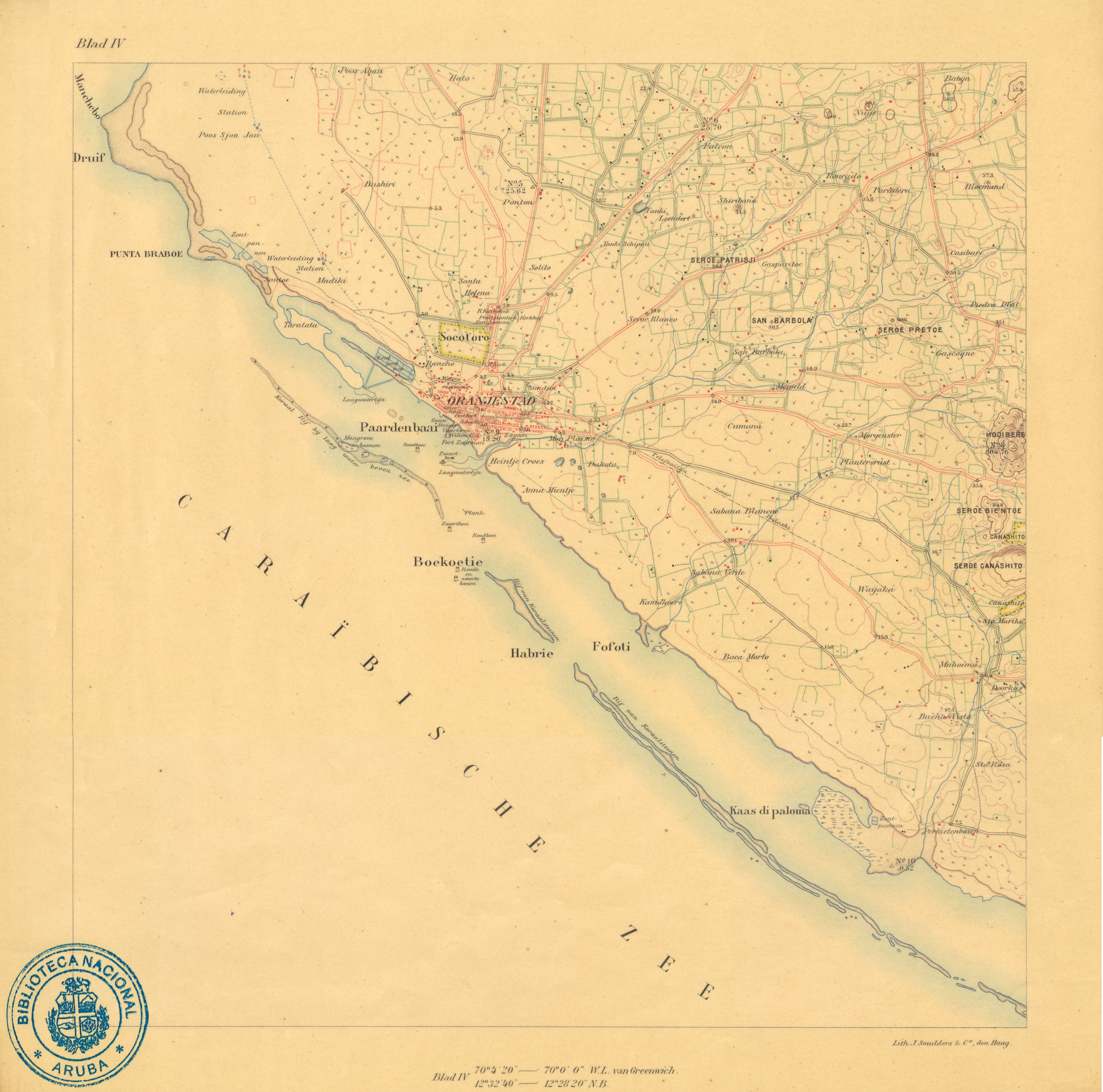
In 1796, Fort Zoutman was constructed near Paardenbaai. It was a natural bay which was accessible to large ships. It was the second harbour on Aruba after Commandeurs Baai (Commander's Bay) in Savaneta. [3] The bay later became known as Paardenbaai (Bay of Horses) because the harbour was mainly used to ship horses to Jamaica and other places. The village near the harbour had no name and was often referred to as Paardenbaai. In 1820, it was named Oranjestad. [4]

In the 1920s, a part of the harbour was reclaimed to extend the city of Oranjestad. [5] With this, the harbour is now partially located in Taratata. [6] [7] In 1928, Arend Petroleum Maatschappij, a subsidiary of Royal Dutch Shell, opened an oil refinery near the harbour. [8] A wharf at the Taratata was used for the refinery, [9] [10] but turned out to be too small, therefore, a 420 metre long pier was constructed near Druif Beach. 8 kilometres of railway lines were laid to link the facilities. On February 16, 1942 there was also a World War II Attack on Aruba at this location. In 1953, Paardenbaai was expanded again with two large basins [11] and completely used the Taratata grounds. The refinery closed in 1958. In 1974, the pier and the refinery were demolished and replaced by a tourist resort with a large beach. Eagle Beach is nowadays one of the busiest beaches of the island. [12]

The harbour was large enough, however it used to be shared by cargo and cruise ships which often caused problems. [13] It was decided to move cargo to Barcadera. The first priority was to move the container terminal. Work began in 2011, and the move was completed in 2015. [14] In 2016, Barcadera was officially opened, and Paardenbaai became a harbour for passengers only. [13]

Paardenbaai has five berths and is open all day and night. [2] The tram of Oranjestad has a terminal at Port of Call which is located near the harbour. [15]

Related Research Articles

<span class="mw-page-title-main">Aruba</span> Caribbean constituent country of the Kingdom of the Netherlands

Aruba, officially the Country of Aruba, is a constituent country of the Kingdom of the Netherlands physically located in the mid-south of the Caribbean Sea, about 29 kilometres (18 mi) north of the Venezuela peninsula of Paraguaná and 80 kilometres (50 mi) northwest of Curaçao. It measures 32 kilometres (20 mi) long from its northwestern to its southeastern end and 10 kilometres (6 mi) across at its widest point. Together with Bonaire and Curaçao, Aruba forms a group referred to as the ABC islands. Collectively, these and the other three Dutch substantial islands in the Caribbean are often called the Dutch Caribbean, of which Aruba has about one-third of the population. In 1986, it became a constituent country within the Kingdom of the Netherlands, and acquired the formal name the Country of Aruba.

<span class="mw-page-title-main">Transport in Aruba</span>

Taxis, buses, and personal automobiles are the most common ways to travel in Aruba. The majority of the roads are paved, but toward the interior of the island the roads are less commonly paved. Coastal areas most often feature paved roads. With a total of 800 km of road, 287 km are unpaved.

<span class="mw-page-title-main">Willemstad</span> Capital and the largest city of Curaçao

Willemstad is the capital city of Curaçao, an island in the southern Caribbean Sea that forms a constituent country of the Kingdom of the Netherlands. It was the capital of the Netherlands Antilles prior to its dissolution in 2010. The historic centre of the city consists of four quarters: the Punda and Otrobanda, which are separated by the Sint Anna Bay, an inlet that leads into the large natural harbour called the Schottegat, as well as the Scharloo and Pietermaai Smal quarters, which are across from each other on the smaller Waaigat harbour. Willemstad is home to the Curaçao synagogue, the oldest surviving synagogue in the Americas. The city centre, with its unique architecture and harbour entry, has been designated a UNESCO World Heritage Site.

<span class="mw-page-title-main">Oranjestad, Aruba</span> Capital of Aruba

Oranjestad is the capital and largest city of Aruba, a constituent country of the Kingdom of the Netherlands. It is located on the southern coast near the western end of the island country. In the local language, Papiamento, Oranjestad is often referred to as "Playa". In 2010, the population of the capital was 28,294.

<span class="mw-page-title-main">Oranjestad, Sint Eustatius</span> Town in Sint Eustatius, Netherlands

Oranjestad is a small town of 1,038 inhabitants; it is the capital of the island of Sint Eustatius in the Caribbean Netherlands.

<span class="mw-page-title-main">Toronto Harbour</span> Bay on the north shore of Lake Ontario, in Toronto, Ontario, Canada

Toronto Harbour or Toronto Bay is a bay on the north shore of Lake Ontario, in Toronto, Ontario, Canada. It is a natural harbour, protected from Lake Ontario waves by the Toronto Islands. Today, the harbour is used primarily for recreational boating, including personal vessels and pleasure boats providing scenic or party cruises. Ferries travel from docks on the mainland to the Islands, and cargo ships deliver aggregates and raw sugar to industries located in the harbour. Historically, the harbour has been used for military vessels, passenger traffic and cargo traffic. Waterfront uses include residential, recreational, cultural, commercial and industrial sites.

<span class="mw-page-title-main">Port of Rotterdam</span> Seaport in the Netherlands

The Port of Rotterdam is the largest seaport in Europe, and the world's largest seaport outside of East Asia, located in and near the city of Rotterdam, in the province of South Holland in the Netherlands. From 1962 until 2004, it was the world's busiest port by annual cargo tonnage. It was overtaken first in 2004 by the port of Singapore, and since then by Shanghai and other very large Chinese seaports. In 2020, Rotterdam was the world's tenth-largest container port in terms of twenty-foot equivalent units (TEU) handled. In 2017, Rotterdam was also the world's tenth-largest cargo port in terms of annual cargo tonnage.

<span class="mw-page-title-main">Port of Cape Town</span> Seaport of the city of Cape Town, South Africa

The Port of Cape Town is the port of the city of Cape Town, South Africa. It is situated in Table Bay.

<span class="mw-page-title-main">Seroe Colorado</span> Place in Aruba, Kingdom of the Netherlands

Seroe Colorado is a village on the island of Aruba, located at the very southeastern tip of the island. Nowadays it is known for the Anchor in Memory to All Seamen, Between 1878 and 1914, it was the site of the Colorado Guano Mine. The Seroe Colorado Lighthouse is located in Seroe Colorado.

<span class="mw-page-title-main">Savaneta</span> Town and Region in Aruba

Savaneta is a town and region in southeastern Aruba. Until 1797, it was the island's capital city. It is home to the island's oldest surviving home, a 150-year-old cas di torto, or mud hut. The Savaneta region has an estimated area of 27.76 square kilometers and 11,518 inhabitants according to the 2010 census.

<span class="mw-page-title-main">Port of Colombo</span> Port in Sri Lanka

The Port of Colombo is the largest and busiest port in Sri Lanka and the Indian Ocean. Located in Colombo, on the southwestern shores on the Kelani River, it serves as an important terminal in Asia due to its strategic location in the Indian Ocean. During the 1980s, the port underwent rapid modernization with the installation of cranes, gantries and other modern-day terminal requirements.

<span class="mw-page-title-main">Attack on Aruba</span> World War II battle in the Caribbean

The attack on Aruba was an attack on oil installations and tankers by Axis submarines during World War II. On 16 February 1942, a German U-boat attacked the small Dutch island of Aruba. Other submarines patrolled the area for shipping and they sank or damaged tankers. Aruba was home to two of the largest oil refineries in the world during the war against the Axis powers, the Arend Petroleum Maatschappij, situated near the Oranjestad harbor, and the Lago Oil and Transport Company at the San Nicolas harbor. The attack resulted in the disruption of vital Allied fuel production.

<span class="mw-page-title-main">Fort Zoutman</span>

Fort Zoutman is a military fortification at Oranjestad, Aruba. Originally built in 1798 by African slaves, with materials provided by the Amerindians, who performed Statute Labour or corvée for the Dutch West India Company, it is the oldest structure on the island of Aruba, and regarded by UNESCO as a 'Place of Memory of the Slave Trade Route in the Latin Caribbean'. The Willem III Tower was added to the west side of the fort in 1868. The fort and tower were restored and re-opened in 1983 as the Historical Museum of Aruba.

<span class="mw-page-title-main">Spaanse Water</span> Place in Curaçao, Kingdom of the Netherlands

Spaanse Water is a town on the island of Curaçao. It contains the tourist resort Nieuwpoort, the village of Santa Barbara, and the Tafelberg. Spaanse Water is a natural harbour and lagoon located to the east of Willemstad. The lagoon contains several bays and little islands.

<span class="mw-page-title-main">Rancho, Aruba</span> Neighbourhood in Oranjestad West, Aruba, Kingdom of the Netherlands

Rancho, located near Paardenbaai, is one of the old districts of Oranjestad, the capital of Aruba. Originally a fishing village, Rancho has evolved into a neighbourhood of Oranjestad. In the late 20th century, it was annexed by Oranjestad, becoming a part of the city while still retaining its distinct character. The district is known for its monuments and intangible cultural heritage

<span class="mw-page-title-main">Protestant Church (Aruba)</span> Church in Oranjestad, Aruba

The Protestant Church is a church of the Dutch Reformed and Lutheran community in Oranjestad, Aruba. The church is not an official member of any international church organisation. The old church dates from 1846. In 1950, a new church was constructed next to the old church. The old church is the second oldest building of Oranjestad which still exists after Fort Zoutman.

<span class="mw-page-title-main">Barcadera</span> Port in Aruba

Barcadera is the main seaport for cargo ships in Aruba. It is located in Barcadera, district Santa Cruz and was officially opened on 12 April 2016.

<span class="mw-page-title-main">Jules Sedney Harbour</span> Harbour in Paramaribo, Suriname

Jules Sedney Harbour is the main seaport for cargo ships in Paramaribo, Suriname. Until 2016, the harbour was called Nieuwe Haven. It is one of the two main cargo ports of Suriname. The other being Nieuw-Nickerie. Paramaribo used to have a generic harbour at Waterkant. In 1965, Nieuwe Haven opened as a specialised cargo harbour.

<span class="mw-page-title-main">Arend Petroleum Company</span> Oil refinery company (1927-1953)

The Arend Petroleum Company Ltd. (1927–1953), also known as Canadian Eagle Petroleum Company or N.V. Arend Petroleum Maatschappij, operated a refinery on the island of Aruba. The establishment of the Arend Petroleum Company in Aruba was a subsidiary of the Royal Dutch Shell Group. The government generously granted a broad coastal strip at Druif Beach of approximately 5 kilometres in length. The refinery commenced its operation in 1928. However, in 1950, the company was decommissioned, ceasing its refining activities. Nevertheless, it continues to be utilized as an oil storage facility until 1953.

References

  1. 1 2 Benjamins & Snelleman 1917, p. 428.
  2. 1 2 3 "Oranjestad". Aruba Ports. Retrieved 2 May 2021.
  3. "Naar een duurzame inrichting van Aruba" (in Dutch). Ministerie Ruimtelijke Onderwikkeling, Infrastructuur en Milieu. 2019. p. 10. Retrieved 27 April 2021.
  4. Benjamins & Snelleman 1917, p. 59.
  5. "Paardenbaai". Amigoe di Curacao via Delpher.nl (in Dutch). 10 December 1921. Retrieved 2 May 2021.
  6. "Taratata map (historic)" . Retrieved 5 February 2022.
  7. "Taratata map (updated)" . Retrieved 5 February 2022.
  8. "Lago and Eagle: the oil industry on Aruba". Historia di Aruba. Retrieved 29 April 2021.
  9. "Flash chamber at Taratata" . Retrieved 5 February 2022.
  10. "Fractionator at Taratata" . Retrieved 5 February 2022.
  11. "Aerial View Paardenbaai & Taratata" . Retrieved 5 February 2022.
  12. "The Railways of Aruba, 2014". International Steam. Retrieved 2 May 2021.
  13. 1 2 "Nieuwe haven Barcadera op Aruba officieel in gebruik genomen". Navingo Career (in Dutch). Retrieved 2 May 2021.
  14. "Container Port Moves to Barcadera". Aruba Ports. Retrieved 2 May 2021.
  15. "Oranjestad Aruba". Tramz. Retrieved 2 May 2021.

Bibliography