
Odisha, formerly Orissa, is an Indian state located in Eastern India. It is the 8th largest state by area, and the 11th largest by population. The state has the third largest population of Scheduled Tribes in India. It neighbours the states of West Bengal and Jharkhand to the north, Chhattisgarh to the west, Andhra Pradesh to the south. Odisha has a coastline of 485 kilometres (301 mi) along the Bay of Bengal. The region is also known as Utkala and is mentioned in India's national anthem, "Jana Gana Mana". The language of Odisha is Odia, which is one of the Classical Languages of India.
Baripada is a city and a municipality in Mayurbhanj district in the state of Odisha, India. Located along the east bank of the Budhabalanga river, Baripada is the cultural centre of north Odisha. In recent years, it has emerged as an educational hub with the opening of numerous professional colleges.

Rayagada is a district in southern Odisha, a state in India, which became a separate district in October 1992. Its population consists mainly of tribes, primarily the Khonds and the Soras. In addition to Odia, Kui and Sora are spoken by the district's indigenous population. It was founded by Maharajah Vishwanath Dev Gajapati of the Suryavansh dynasty of Jeypore.

Koraput is a district of India in southern Odisha, with headquarters at Koraput. The district is located in the Eastern Ghats and is known for its hilly terrain, rich and diverse types of mineral deposits and its tribal culture and traditions. The district headquarters of Koraput and its largest city, Jeypore are major centres of trade and commerce for South Odisha and fall on an important road connecting Visakhapatnam to Raipur.

Gajapati is a district of Odisha, India. It was created from Ganjam District on 2 October, 1992. Gajapati district was named after Krushna Chandra Gajapati Narayan Deb, the King of the Paralakhemundi estate and the first Prime Minister of Orissa, who is remembered for his contribution in the formation of a separate state, and inclusion of his estate in Odisha. The district headquarters at Paralakhemundi, formerly a Zamindari, has been clustered within a radius of approximately 5 kilometers around the geometric centre of Paralakhemundi. The District is a part of the Red Corridor.

Sambalpur is the fifth largest city in the Indian State of Odisha. It is located on the banks of river Mahanadi, with a population of 335,761. Prehistoric settlements have been recorded there. It is the home of the Sambalpuri Saree.
Bissam Cuttack is a census town in the Rayagada district, within the state of Odisha, India. It is one of the identified Tourist Centres of Odisha.

Gunupur is a Municipality and one of the sub-divisional headquarters of Rayagada district in the Indian state of Odisha. It is the second biggest town in Rayagada district.
Gudari is a town and a Notified Area Council (N.A.C.) in Rayagada district in the Indian state of Odisha.It is the 3rd biggest town in Rayagada District followed by Rayagada and Gunupur in 1st and 2nd.

Maa Markama Temple located at Bissam Cuttack village of Rayagada district is a place of tourist interest. It is the only shrine of Devi Maa Markama and Maa karkama in the Indian state of Odisha. The temple of Maa Karkama is situated next to the temple of Maa Markama. The legend says that the Devi is being worshiped for centuries. However, the temple was constructed in the recent past. A junior college and a university college in Bissam Cuttack are named after Maa Markama. The temple is one of the places of tourist attractions in Rayagada district. Dussehra and chaitra Paraba are celebrated every year at the temple. The nearest rail head is Chatikona, which is 7 km from Bissam Cuttack.

Chatikona is a small village of Rayagada district in the state of Odisha, India. It is one of the identified Tourist Centres of Odisha.
Gunupur is a Vidhan Sabha constituency of Rayagada district, Odisha.

Nilakantheswar Temple at Padmapur, standing on the Jagamanda hills makes the village well known for the Buddhist temple. The temple is built on only seven rocks. There are also three other shiva temples, i.e. Pudukeswar, Dhabaleswar, and Mallikeswar, on the hillock. This 7th century old buddhist temple makes Padmapur a tourist center of Rayagada district. The temple is very often referred as shrine of Manikeswar Siva. Recently a small cemented front hall has been added to the original structure.
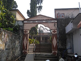
Govt. Boys' High School, Gunupur, is located beside the banks of Vamsadhara River at Gunupur of Rayagada district in the Indian state of Odisha. The original structure of the public educational building is totally made of stone & the institution stands on an elevated plot of the town. It is one of the oldest High Schools of the district. It is an oriya medium school affiliated to the Board of Secondary Education, Odisha under State Government of Odisha. The school celebrates its Centenary celebration in April 2015.
Kujendri is a small village of Rayagada district in the state of Odisha, India. There is a Govt. High school of welfare department since 1949. The veteran Gandhian and Jamnalal Bajaj award winner Biswanath Pattnaik came to kujendri in around 1940, founded Banabasi Seva Samiti and worked for the development of local tribal people. The village is well known as the birthplace of the tribal lady freedom fighter Sandi Sabara. who met Sri Patnaik there and worked in the Bhoodan movement. Kujendri was an important place in the history of Bhoodan movement. The Bhoodan activists in a padayatra, in the leadership of Acharya Vinoba Bhave reached here on 8 March 1952 and mobilized the people of the area to donate lands. It also has a temple-"Trinath temple", built by late shri Appana choudhury.
Minajhola is located near Gudari in the Rayagada district, in the Indian state of Odisha. It is famous for the Shiva temple, one of the tourist attractions of the district. The main place of attraction is a shiva temple at the confluence of three rivers i.e. Vamsadhara, Chauladhua & Phalaphalia here. Situated at the heart of the dense forest, It is one of the identified Tourist Centres of odisha. Minajhola is famous for its Shiva temple, People from far and near visit the shrine during the festival of Shivaratri

Durgi is a census village & Panchayat Headquarter of Bissam Cuttack Block in Rayagada district of Odisha, India. There are total 439 families residing in this village. The wards/ villages comes under Durgi Panchayat are:- Durgi, Bhaleri, Kundanpadar, Rengabai, Barangpadar, Thambalpadhu, Budhanagar, Kachapai, Kalipadar, Kurankul, Tentili Kalipadar, Mulipada, Dharamguda, Balipadar, Haduguda, Huruguda, Khariguda and IAY Colony.
Jagannath Temple,(Odia: ଶ୍ରୀ ଜଗନ୍ନାଥ ମନ୍ଦିର) Gunupur, stands at the eastern end of the town Gunupur in the Old Gunupur area. The old temple was built by the Jeypore Maharaja Vikramadeb more than 100 years back.
Sirijholi, also spelled Sirijholly), is a medium-sized village located in the Indian state of Odisha in the Rayagada district. It is the panchayat headquarter of the Sirijholi Grama Panchayat and is administrated by a Sarapancha.


