Padstow Coastal Gun Battery

Last updated

Padstow Coastal Gun Battery
Padstow, Cornwall in  United Kingdom
The Old Barbette and Magazine with the Concrete Gun Platform on Top.jpg
The old barbette
United Kingdom adm location map.svg
Red pog.svg
Padstow Coastal Gun Battery
Coordinates 50°32′47.73″N4°56′4.71″W / 50.5465917°N 4.9346417°W / 50.5465917; -4.9346417
Site information
ConditionRuined

Padstow Coastal Gun Battery was built in the summer of 1940 at the northern end of the Bodmin Stop Line to defend against a German invasion of Britain. It utilised an old military site first established during the War of American Independence north of Padstow overlooking the Camel Estuary and known as Gun Point. Padstow is a port on the north Cornish coast. [1] [2] [3]

Contents

Establishment of the battery

DateState of the Battery
July 1940The layout of the battery was detailed by Col Oliver C.F.D, Plymouth, and was constructed under the supervision of Captain Pockles, Royal Engineers, Bodmin, for two 4 inches naval guns. The old magazine from 1870 which was built of a well-built brick arch was uncovered and tested. It was recovered and put to use as Magazine No 1. Magazine No 2 was built from scratch with reinforced concrete roof and sides and an inner brick wall with a cavity and a raised floor. One gun platform was built on top of the old circular barbette and the other on a new platform built towards the northern hedge.
14 August 1940Both guns were ready for action. They were 4 inch Breech Loading Mk VII naval guns.
23 August 1940Major Kirby, I.G., Plymouth, arrived with a party. All sights were tested, buffer system checked and each gun fired three shells seaward, with a range of 4500 yards. The fall of the shot was observed to be consistent.

The battery was part of No 19 Coast Artillery Group whose headquarters was at Lanwithan, Lostwithiel. [3] [4]

Role of the battery

The role of the Coast Battery was: [3]

i)                   The protection of the port and beaches against attack by sea or landings on the beaches;

ii)                  The protection of shipping in the approaches to the port;

iii)                To form defended posts against landward attack;

iv)                To deal with airborne troops landing in the vicinity;

v)                  To engage landward targets.

The seaward roles take precedence over all others and will be maintained up until the last moment.

The tasks of the battery in order of priority were:

i)                   Engagements of enemy transports and landing craft;

ii)                  Engagement of enemy warships attacking the port or defences;

iii)                Engagement of targets on or adjacent to landing beaches;

iv)                Support of the examination service where in force.

CASLs

The battery was served by two Coastal Artillery Search Lights. One was positioned north of the battery and the other south on the southern side of St George's Cove. A generator house and fuel store were constructed in the Cove. [3] [4]

Life of the battery

In 1940, the Garrison had 4 officers and 101 Other Ranks. The detachments of 21 men each were on duty for 24 hours from 1300 hours on one day to 1300 hours the next. The troops were billeted at Prideaux Place, Padstow which had sleeping accommodation for 120 men & 4 officers, a cookhouse & dining hall and an officer's mess & kitchen. Prideaux Place served as the Battery Headquarters. [3] [5] Water at the site was a problem and to begin with, the battery had to transport water for drinking and washing from Prideaux Place in dustbins. Later, the old Victorian water tank was cleaned and that was then used. In August 1940, an ADS Advance Dressing Station was set up at Tregirls Farm. Sick Parade was held daily at 1000 hours at the Fisherman's Institute in the town. [3] On the night of 7 September 1940, the battery was at the utmost readiness following the issue of Codeword Cromwell, meaning invasion imminent. The Resident Naval Officer in overall charge of the defence of Padstow, Rear Admiral Gordon Campbell, V.C., and the officer in charge of the land forces, Lt Dare Wilson of the 8th Battalion Royal Northumberland Fusiliers, kept watch from the control bunker of the underwater minefield laid across the estuary. No invasion arrived. [6] [7] On Saturday 5 October 1940, Padstow was bombed at 8pm but the battery was not hit. Three people – three generations from one family - were killed in New Street, Padstow. Six houses were extensively damaged and 61 other buildings suffered minor damage. The fin of one of the bombs is on display at Padstow Museum. [8] [9] [10] On 8 October 1940, Major Kirby, I.G., from Plymouth, arrived with a towing launch. Two rafts 20 yards apart were attached to the launch. The targets were engaged as they came into view from Pentire Head to Newland Rock. The average range was 4400 yards and five hits were registered out of 13 shots. [3] On 15 February 1941, both guns fired 10 rounds practice shells together in 3 series at a single Hans Kay target pulled behind a launch travelling at a speed of about 10 knots. Six hits were registered. By May 1941, two War Shelters had been built to accommodate the Watch on Duty whilst the Reserve Watch slept in two huts erected at the bottom of the field by St George's Cove. In May 1942, the two naval guns were returned to sea to help in the Battle of the Atlantic. They left Padstow from the town railway station.[ citation needed ] They were replaced by two French 138mm naval guns. These required new gun houses. No 1 was built south of the old barbette and magazine. Its platform can easily be found today with mounting bolts still in place. No 2 was built just north of the old northern gun house and its location can easily be found by the ready use lockers that are still extant. The Battery Observation Post was also extended at this time. On 11 May 1942, both 138mm guns had been proofed and were ready for action. On 17 March 1943, the examination service was discontinued as such and the majority of Officers, NCO's and men were released for service overseas and the guns put into care and preservation. In November 1943, the strength was reduced to one NCO and two men and the ammunition removed to Fort Picklecombe for storage. [3] The guns were removed in July 1945. [2]

Remains of the battery

Much of the 1870 barbette and No 1 Magazine can still be found at Gun Point, along with the large Victorian water tank. The 1940 concrete gun platform is still on top of the barbette although some of the concrete block cladding has fallen victim to coastal erosion. The gun platforms for the 1942 guns can still be found. No 2 Magazine still exists underground but has been filled so it is not accessible. [2] The Engine House and Fuel shed still stand at St George's Cove. [4] [11] Prideaux Place still remains and is a tourist attraction and events venue today. [12]

Gun Point is referenced in Major Dare Wilson's autobiography ‘Tempting The Fates’, which details his work on preparing the landward defences for Padstow.

Gun Point is also referenced in the historical novel ‘No Small Stir’ by Cornish author Phil Hadley where Major Isaac Trevennel meets Rear Admiral Campbell to discuss the defences of Padstow.

Related Research Articles

<span class="mw-page-title-main">Padstow</span> Town in Cornwall, England

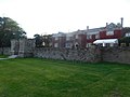
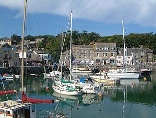
Padstow is a town, civil parish and fishing port on the north coast of Cornwall, England. The town is situated on the west bank of the River Camel estuary approximately 5 miles (8.0 km) northwest of Wadebridge, 10 miles (16 km) northwest of Bodmin and 10 miles (16 km) northeast of Newquay. The population of Padstow civil parish was 3,162 in the 2001 census, reducing to 2,993 at the 2011 census. In addition an electoral ward with the same name exists but extends as far as Trevose Head. The population for this ward is 4,434

<span class="mw-page-title-main">River Camel</span> River in Cornwall, England

The River Camel is a river in Cornwall, England. It rises on the edge of Bodmin Moor and with its tributaries its catchment area covers much of North Cornwall. The river flows into the eastern Celtic Sea between Stepper Point and Pentire Point having covered about 30 miles, making it the second longest river wholly in Cornwall. The river is tidal upstream to Egloshayle and is popular for sailing, birdwatching and fishing. The name Camel comes from the Cornish language for 'the crooked one', a reference to its winding course. Historically the river was divided into three named stretches. Heyl was the name for the estuary up to Egloshayle, the River Allen was the stretch between Egloshayle and Trecarne, whilst the Camel was reserved for the stretch of river between its source and Trecarne.

<span class="mw-page-title-main">Rock, Cornwall</span> Human settlement in England

Rock is a coastal fishing village in Cornwall, England, United Kingdom. It is opposite Padstow on the north-east bank of the River Camel estuary. The village is in the civil parish of St Minver Lowlands about 4 miles (6.4 km) north-west of Wadebridge.

<span class="mw-page-title-main">Prideaux Place</span>

Prideaux Place is a grade I listed Elizabethan country house in the parish of Padstow, Cornwall, England. It has been the home of the Prideaux family for over 400 years. The house was built in 1592 by Sir Nicholas Prideaux (1550–1627), a distinguished lawyer, and was enlarged and modified by successive generations, most notably by his great-great-grandson Edmund Prideaux (1693–1745) and by the latter's grandson Rev. Charles Prideaux-Brune (1760–1833). The present building, containing 81 rooms, combines the traditional E-shape of Elizabethan architecture with the 18th-century exuberance of Horace Walpole’s Strawberry Hill Gothic.

<span class="mw-page-title-main">Camel Trail</span> Hiking and cycling trail in Cornwall, England

The Camel Trail is a permissive cycleway in Cornwall, England, United Kingdom, that provides a recreational route for walkers, runners, cyclists and horse riders. The trail is flat ; running from Padstow to Wenford Bridge via Wadebridge and Bodmin, it is 17.3 miles (27.8 km) long and used by an estimated 400,000 users each year generating an income of approximately £3 million a year.

<span class="mw-page-title-main">St Mawes Castle</span> Device Fort in Falmouth, England

St Mawes Castle is an artillery fort constructed by Henry VIII near Falmouth, Cornwall, between 1540 and 1542. It formed part of the King's Device programme to protect against invasion from France and the Holy Roman Empire, and defended the Carrick Roads waterway at the mouth of the River Fal. The castle was built under the direction of Thomas Treffry to a clover leaf design, with a four-storey central tower and three protruding, round bastions that formed gun platforms. It was initially armed with 19 artillery pieces, intended for use against enemy shipping, operating in partnership with its sister castle of Pendennis on the other side of the estuary. During the English Civil War, St Mawes was held by Royalist supporters of King Charles I, but surrendered to a Parliamentary army in 1646 in the final phase of the conflict.

<span class="mw-page-title-main">St Catherine's Castle</span> Castle in Cornwall, England

St Catherine's Castle is a Henrician castle in Cornwall, England, built by Thomas Treffry between approximately 1538 and 1540, in response to fears of an invasion of England by France and the Holy Roman Empire. The D-shaped, stone fortification, equipped with five gun-ports for cannon, overlooked the mouth of the River Fowey in Cornwall. It was protected by a curtain wall and the surrounding cliffs. The castle remained in use for many years until it was closed at the end of the Napoleonic Wars in 1815. Brought back into service in 1855 during the Crimean War, it was fitted with two new artillery positions, but it soon became obsolete and was abandoned. During the Second World War the castle was refortified and used to house a battery of naval guns, protecting the coast against the threat of German attack. At the end of the conflict the castle was restored to its previous condition and is now managed by English Heritage as a tourist attraction.

<span class="mw-page-title-main">Whitsand Bay</span>

Whitsand Bay, situated in south east Cornwall, England, runs from Rame Head in the east to Portwrinkle in the west. It is characterised by sheer, high cliffs, dramatic scenery and long stretches of sandy beaches. The South West Coast Path runs the length of the bay.

<span class="mw-page-title-main">Wadebridge railway station</span> Disused railway station in Cornwall, England

Wadebridge railway station was a railway station that served the town of Wadebridge in Cornwall, England. It was on the Bodmin and Wadebridge Railway.

<span class="mw-page-title-main">Stepper Point</span> Headland on the coast of north Cornwall, England

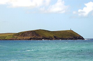
Stepper Point is a headland on the Atlantic coast in north Cornwall, England, United Kingdom. It is at grid reference SW911781. Stepper Point and Pentire Point stand at either side of the mouth of the River Camel; Stepper to the south-west, Pentire to the north-east.

Brixham Battery and Battery Gardens are an open space on the sea shore in Brixham, Devon at grid reference SX920569. They are a traditional observation point for Brixham trawler races, both past and present.

<span class="mw-page-title-main">BL 9.2-inch Mk IX – X naval gun</span> Naval gun

The BL 9.2-inch Mk IX and Mk X guns were British breech loading 9.2-inch (234 mm) guns of 46.7 calibre, in service from 1899 to the 1950s as naval and coast defence guns. They had possibly the longest, most varied and successful service history of any British heavy ordnance.

<span class="mw-page-title-main">Hawker's Cove, Cornwall</span> Human settlement in England

Hawker's Cove is a small coastal settlement in north Cornwall, England, United Kingdom. It is situated one-and-a-half miles north of Padstow on the west side of the River Camel estuary .

<span class="mw-page-title-main">Doom Bar</span> Sandbar at the mouth of the River Camel, Cornwall, England

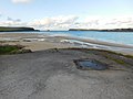
The Doom Bar is a sandbar at the mouth of the estuary of the River Camel, where it meets the Celtic Sea on the north coast of Cornwall, England. Like two other permanent sandbanks further up the estuary, the Doom Bar is composed mainly of marine sand that is continually being carried up from the seabed. More than 60 percent of the sand is derived from marine shells, making it an important source of agricultural lime, which has been collected for hundreds of years; an estimated 10 million tons of sand or more has been removed from the estuary since the early nineteenth century, mainly by dredging.

<span class="mw-page-title-main">Coastal defence and fortification</span> Measures to protect against a military attack by a coastline

Coastal defenceand coastal fortification are measures taken to provide protection against military attack at or near a coastline, for example, fortifications and coastal artillery. Because an invading enemy normally requires a port or harbour to sustain operations, such defences are usually concentrated around such facilities, or places where such facilities could be constructed. Coastal artillery fortifications generally followed the development of land fortifications, usually incorporating land defences; sometimes separate land defence forts were built to protect coastal forts. Through the middle 19th century, coastal forts could be bastion forts, star forts, polygonal forts, or sea forts, the first three types often with detached gun batteries called "water batteries". Coastal defence weapons throughout history were heavy naval guns or weapons based on them, often supplemented by lighter weapons. In the late 19th century separate batteries of coastal artillery replaced forts in some countries; in some areas these became widely separated geographically through the mid-20th century as weapon ranges increased. The amount of landward defence provided began to vary by country from the late 19th century; by 1900 new US forts almost totally neglected these defences. Booms were also usually part of a protected harbor's defences. In the middle 19th century underwater minefields and later controlled mines were often used, or stored in peacetime to be available in wartime. With the rise of the submarine threat at the beginning of the 20th century, anti-submarine nets were used extensively, usually added to boom defences, with major warships often being equipped with them through early World War I. In World War I railway artillery emerged and soon became part of coastal artillery in some countries; with railway artillery in coast defence some type of revolving mount had to be provided to allow tracking of fast-moving targets.

<span class="mw-page-title-main">Tregirls</span>

<span class="mw-page-title-main">Fort Mahon</span>

Fort Mahon is a sea fort by the commune of Ambleteuse in the Pas-de-Calais, northern France. The fort was built at the end of the 17th century by the military architect Vauban on the orders of Louis XIV to defend the port in the estuary of the Slack. It was designated a Monument historique in the 1960s.

<span class="mw-page-title-main">Camden Fort Meagher</span>

Camden Fort Meagher is a coastal defence fortification close to Crosshaven, County Cork, Ireland. Together with similar structures at Fort Mitchell, Fort Davis (Whitegate), and Templebreedy Battery, the fort was built to defend the mouth of Cork Harbour. Though originally constructed in the 16th century, the current structures of the fort date to the 1860s. Originally named Fort Camden and operated by the British Armed Forces, the fort was handed-over to the Irish Defence Forces in 1938. Renamed Fort Meagher in honour of Thomas Francis Meagher, it remained an Irish military installation until 1989 when the Irish Army handed the fort over to Cork County Council. It remained largely overgrown until 2010 when a group of local volunteers began restoration and development of the fort for heritage and tourism purposes. The fort was renamed Camden Fort Meagher and is now open seasonally to visitors, with exhibits on the fort's Brennan torpedo installation.

<span class="mw-page-title-main">56th (Cornwall) Heavy Anti-Aircraft Regiment, Royal Artillery</span> Military unit

56th (Cornwall) Heavy Anti-Aircraft Regiment, Royal Artillery was a volunteer air defence regiment of Britain's Territorial Army (TA). Originally raised in 1920 as a medium artillery regiment, it was converted to the anti-aircraft role in 1932. During the Second World War, it was employed in Home Defence, in Iceland and then in India, where it was temporarily converted back to medium artillery. Postwar, it reverted to air defence until disbandment in 1955.

<span class="mw-page-title-main">Par Coastal Gun Battery</span>

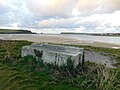
The Par Coastal Gun Battery was a coastal gun battery constructed in the summer of 1940 when Britain was facing the threat of invasion from Nazi Germany. It is situated on the former site of the Par Consols Mine, overlooking Par Docks.

References

  1. "Padstow", Wikipedia, 2 November 2020, retrieved 6 November 2020
  2. 1 2 3 Defences of Padstow by Tim Parr. Leaflet Published by Padstow Museum
  3. 1 2 3 4 5 6 7 8 National Archives - WO 192-151 Padstow Battery (1870-1945) Fort Record Book 1941-1945
  4. 1 2 3 "No Small Stir - The Bodmin Stop Line: Part 1 The Camel Estuary - YouTube". www.youtube.com. Retrieved 6 November 2020.
  5. "Prideaux Place", Wikipedia, 18 October 2020, retrieved 6 November 2020
  6. Wilson, Dare (2006). Tempting The Fates. ISBN   978-1844154357.
  7. "Gordon Campbell (Royal Navy officer)", Wikipedia, 3 July 2020, retrieved 6 November 2020
  8. "BBC - WW2 People's War - "When Bombs Fell" - The air-raids on Cornwall during WW2 : Part 2 - 1940 (complete year)". www.bbc.co.uk. Retrieved 6 November 2020.
  9. "BBC - WW2 People's War - My Memories of WW2: A Child in Padstow". www.bbc.co.uk. Retrieved 6 November 2020.
  10. "Padstow Museum". www.padstowmuseum.co.uk. Retrieved 6 November 2020.
  11. "Heritage Gateway - Results". www.heritagegateway.org.uk. Retrieved 6 November 2020.
  12. "Prideaux Place Padstow | A Beautiful Historic House in Padstow, Cornwall". Prideaux Place .{{cite web}}: CS1 maint: url-status (link)