Paeroa railway station

Last updated

Paeroa railway station
Paeroa 1913.jpg
1895 Paeroa station and Paeroa Hotel in 1913
General information
Coordinates 37°22′02″S175°39′59″E / 37.3671°S 175.6664°E / -37.3671; 175.6664
Elevation5 m (16 ft)
Owned by New Zealand Railways Department
Line(s) Thames Branch
Distance Morrinsville 44.12 km (27.41 mi)
History
Opened20 December 1895
Closed28 June 1991
closed to passengers 20 July 1959
Rebuilt980 m (0.61 mi) to the north, on 1 September 1925
Previous namesOhinemuri until 1 March 1896
Services
Preceding station Historical railways Following station
Tirohia
Line closed,
station closed
9.84 km (6.11 mi)
  Thames Branch
NZR
 Komata North
Line closed,
station closed
3.29 km (2.04 mi)
Paeroa South
Line closed,
station closed
2.8 km (1.7 mi)
  East Coast Main Trunk
NZR
  Mackaytown
Line closed,
station closed
3.12 km (1.94 mi)

Paeroa railway station is a former railway station in Paeroa; on the Thames Branch, and on the East Coast Main Trunk Railway to Waihi. Between 1895 and 1991 Paeroa had a station at the north end of the town centre, followed by one further north, another back near the town centre and then another over a mile south of the town.

Contents

1895 station

Paeroa 1925 station Paeroa 1924 station.jpg
Paeroa 1925 station

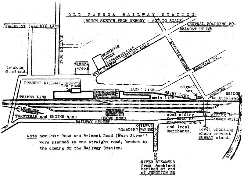
The first station was opened on 20 December 1895 by the local MP and Railways Minister, Alfred Cadman, when the line was extended 22.52 km (13.99 mi) from Te Aroha. [1] It was at the north end of the main street, between Belmont Road and Railway Street. [2] A coal shed and telephone office were added in 1896, when the special station also had a platform, cart approach, 40 ft (12 m) x 30 ft (9.1 m) goods shed, loading bank, cattle yards, engine turntable and shed, stationmaster's house, urinals and a passing loop for 44 wagons. The station was improved in 1897, including access to a refreshment room, gas lighting in 1899 and a bookstall in 1910. A new turntable in 1900 allowed use of J Class engines. [3]

Ohinemuri County Council asked for the name to be changed from Ohinemuri to Paeroa, which was done on 1 March 1896. [3]

Paeroa remained a terminus until 19 December 1898, when the line was extended to Thames North. It also became busier from 17 August 1903, when the line to Waihi opened to goods and from 5 September, when passengers could travel to Waihi. [3]

Paeroa's 1925 station in 1963, showing the engine turning triangle and the junction to Pokeno Paeroa railway station in 1963.jpg
Paeroa's 1925 station in 1963, showing the engine turning triangle and the junction to Pokeno

In 1926, after the station closed, a 1908 band rotunda was moved to the railway reserve, where it remains. [4]

Railway wharf

The wharves on the Ohinemuri River upstream of the railway bridge had restricted access once the bridge was built. A railway wharf opened just downstream of the bridge at the same time as the station, but charges were set at a level to encourage use of the railway, rather than the sea route from Auckland. Therefore the wharf had limited use, with trade moving to the Junction Wharf, further downstream, [5] where a horse-drawn tramway ran from 1 September 1896 [6] to March 1897, using rolling stock from the Grahamstown and Tararu Tramway. [7] On 11 May 1896 the tramway applied for permission to cross the railway, [3] but it seems not to have been given. [8] Similarly, a Ohinemuri County Council request for control of the railway wharf was refused. By 1909 silt from mine tailings had made the river hard to navigate and the wharf wasn't used after 1916, when the rail connection was lifted to avoid changes needed to accommodate a new flood protection stop bank along the river. In 1918 the Railway Wharf was finally closed. [3] [5]

1925 station

Site of 1925 Paeroa station Site of 1924 Paeroa station.jpg
Site of 1925 Paeroa station

On Tuesday, 1 September 1925 [3] the 1895 station was replaced by one 980 m (0.61 mi) to the north. [9] In 1925/26 the Ohinemuri Bridge was replaced by one 7 ft 6 in (2.29 m) higher, [10] as the flood stop bank was being raised, and the new station was clear of the bank needed to climb to the new bridge level. Most of the 1895 station was in too poor a condition to move, but part of the old platform front was used for a new dock platform. In 1928 improvements included electric lighting, moving the old verandah to the new station, a bicycle shed, a loading bank with a concrete front, new pits in the engine shed [3] and a larger refreshment room, which was used until the station closed to passengers in 1959. [11] Another reason for moving the station to an area where it had room to grow was the congested yard, which was causing delays. There were also private sidings for British Imperial Oil Co (1926) and Vacuum Oil Co (1945). The 55 ft (17 m) turntable was too short for AB class engines and its foundation was sinking, so it was replaced by a reversing triangle, completed by 8 January 1940 at a cost of £2260. [3]

17 railway houses remain on Aorangi Rd, Ainsley Rd and Porritt St. [12] As well as the stationmaster's house, there was a house for a train examiner in 1910 and houses added in 1945 and 1956. [3]

The station closed to passengers on 20 July 1959, and to goods on 28 June 1991 with the closing of the Thames Branch. [13]

The station building was then moved to Waikino, for use as a combined western terminus for Goldfields Railway and as a shop/cafe for Waikino. [14]

Paeroa–Pokeno Line

In 1938 a temporary office at Paeroa, costing £377 14s 3d, was added for the building of the Paeroa–Pokeno Line. A request for a link was made in 1905 [15] and a route was surveyed in 1926. [16] Proposals were also made to shorten the route by a further 12 mi (19 km), by starting it at Manurewa and serving Hunua. [17] Work started in 1938 on the 42 mi 69 ch (69.0 km) line, which would have shortened the distance from Auckland to towns on the ECMT by 45 mi 69 ch (73.8 km). In March 1937 the Kerepeehi Farmers' Union supported construction of the Paeroa to Pokeno link. [18]

Minister of Public Works, Bob Semple, turned the first sod on 27 January 1938 at Paeroa [19] and about 32 mi (51 km) of the 42 mi (68 km) line had been started [20] when work was abandoned in 1940. [21] Work was still making slow progress in 1950, when a paragraph in the Ministry of Works annual report said 20 private crossings had been formed and metaled and 456 ft (139 m) of culverts installed. [22] In 1954 it was noted the major cost would be a £3100, 30 ft (9.1 m) bridge across the Waihou, the abutments already being in place. [3] Most of the work was still in place in the 1960s. [23]

The Pokeno link was to be the first part of the East Coast Main Trunk Railway. With the opening of the Kaimai Tunnel in 1979, the Paeroa to Katikati section of the East Coast Main Trunk was closed.

1932 station

From 11 October 1932 Paeroa Township was on the site of the old station, as a stopping place for trains towards Waihi, to allow more convenient access to the town centre. After Mackaytown closed on 28 July 1940 its shelter shed was resited on 3 October to Township station. When the station closed in 1959, the shed was again moved, to Borrell Road, further along the line, near Te Puna. [24]

Paeroa South in 1975, between the triangle and Rotokohu Road Paeroa South on 26 January 1975.jpg
Paeroa South in 1975, between the triangle and Rotokohu Road

1959 station

Paeroa South, at the eastern end of the triangle on Rotokohu Road, opened on 20 July 1959 and was served by railcars until closure on 11 March 1979. [13] [25]

Hauraki Rail Trail

Both the Thames Branch and ECMT through Paeroa are now part of the Hauraki Rail Trail cycle route, though the railway bridge over the Ohinemuri River has been removed and the Trail uses a footbridge alongside the SH26 bridge. [26]

See also

Related Research Articles

<span class="mw-page-title-main">Te Aroha</span> Town in Waikato, New Zealand

Te Aroha is a rural town in the Waikato region of New Zealand with a population of 3,906 people in the 2013 census, an increase of 138 people since 2006. It is 53 km (33 mi) northeast of Hamilton and 50 km (31 mi) south of Thames. It sits at the foot of 952 metres (3,123 ft) Mount Te Aroha, the highest point in the Kaimai Range.

<span class="mw-page-title-main">Waihou River</span> River in Waikato, New Zealand

The Waihou River is located in the northern North Island of New Zealand. Its former name, Thames River, was bestowed by Captain James Cook in November 1769, when he explored 14 mi (23 km) of the river from the mouth. An older Māori name was "Wai Kahou Rounga". A 1947 Geographic Board enquiry ruled that the official name would be Waihou.

<span class="mw-page-title-main">Ohinemuri River</span> River in New Zealand

The Ohinemuri River is located in the northern half of New Zealand's North Island, at the base of the Coromandel Peninsula.

<span class="mw-page-title-main">Piako River</span> River in New Zealand

The Piako River is a lowland river system that drains into the Firth of Thames on the North Island of New Zealand. Together with the Waihou River, it is one of the two main rivers systems which drains the Hauraki Plains. It is the dominant river system in the Matamata-Piako District, and on its journey it passes through the towns of Morrinsville and Ngatea.

<span class="mw-page-title-main">East Coast Main Trunk</span> Railway in New Zealand running between Hamilton and Kawerau

The East Coast Main Trunk (ECMT) is a railway line in the North Island of New Zealand, originally running between Hamilton and Taneatua via Tauranga, connecting the Waikato with the Bay of Plenty. The ECMT now runs between Hamilton and Kawerau, with a branch line to Taneatua from the junction at Hawkens. The line is built to narrow gauge of 1,067 mm, the uniform gauge in New Zealand. It was known as the East Coast Main Trunk Railway until 2011, when the word "Railway" was dropped.

<span class="mw-page-title-main">Hikutaia</span> Place in Waikato, New Zealand

Hikutaia is a locality on the Hauraki Plains of New Zealand. It lies on State Highway 26, south east of Thames and north of Paeroa. The Hikutaia River runs from the Coromandel Range through the area to join the Waihou River.

<span class="mw-page-title-main">Matatoki</span> Place in Waikato, New Zealand

Matatoki is a locality on the Hauraki Plains of New Zealand. It lies on State Highway 26, south east of Thames and north of Paeroa. The Matatoki Stream runs from the Coromandel Range through the area to join the Waihou River.

<span class="mw-page-title-main">Thames Branch</span>

The Thames Branch railway line connected Thames, New Zealand, with Hamilton and was originally part of the East Coast Main Trunk railway. Part of the line between Morrinsville and Waitoa remains open and is in use as the Waitoa Branch line, connecting to the Fonterra Dairy Factory at Waitoa.

<span class="mw-page-title-main">Waitawheta River</span> River in New Zealand

The Waitawheta River is a river of the Waikato Region of New Zealand's North Island. It flows from a point south-east of Mount Te Aroha in the Kaimai Range to the Karangahake Gorge at the foot of the Coromandel Peninsula to reach the Ohinemuri River at Karangahake, five kilometres east of Paeroa.

<span class="mw-page-title-main">Helensville railway station</span> Defunct railway station in New Zealand

Helensville railway station formerly served the town of Helensville, 60.47 km (37.57 mi) northwest of Auckland Strand, in the North Island of New Zealand. It was a stop on the North Auckland Line, and was the next major station north of Waitākere. Occasionally it was called the Helensville North Railway Station.

<span class="mw-page-title-main">Hauraki Rail Trail</span> New Zealand rail trail

The Hauraki Rail Trail is one of the Great Rides of the New Zealand Cycle Trail system, using parts of the abandoned ECMT and Thames Branch railways in the Hauraki Gulf plains and the Coromandel Peninsula.

<span class="mw-page-title-main">Ohinemuri County</span>

Ohinemuri County was one of the counties of New Zealand of the North Island.

The Paeroa-Pokeno railway line or deviation in the upper North Island of New Zealand between Paeroa on the East Coast Main Trunk (ECMT) and Pokeno on the North Island Main Trunk (NIMT) was a proposed route with construction started but abandoned. The proposal has been revived in recent years as part of a more direct route between Auckland and Tauranga.

<span class="mw-page-title-main">Pokeno railway station</span> Defunct railway station in New Zealand

The Pokeno railway station is a former railway station in Pokeno, New Zealand on the North Island Main Trunk line. It opened for passengers on 20 May 1875, and for goods on 6 April 1879. It was 39 mi 36 ch (63.5 km) south of Auckland and 41 mi 52 ch (67.0 km).

<span class="mw-page-title-main">Public transport in Waikato</span> Public transport operator in the Waikato region, New Zealand

Public transport in Hamilton and the Waikato Region consists mainly of bus services, as well as some limited train and ferry services. Services are mainly infrequent, and investment hasn't been sufficient to compete with cars, so that subsidies, first introduced in 1971, have increased.

<span class="mw-page-title-main">Northern Steamship Company</span> New Zealand local shipping and transport company

The Northern Steam Ship Company Ltd (NSS) served the northern half of the North Island of New Zealand from 1881 to 1974. Its headquarters, the Northern Steam Ship Company Building, remains in use on Quay St, Auckland as a bar.

<span class="mw-page-title-main">Waihi-Waikino Gold Tramway</span>

The Waihi-Waikino Gold Tramway was a narrow-gauge railway which ran between gold mines at Waihi and the Victoria Battery at Waikino. Owned by the Waihi Gold Mining Company, it operated from 1897 to 1952. It was the only private railway in New Zealand used by the gold industry.

Tirohia is a rural community in the Hauraki District and Waikato region of New Zealand's North Island. It was one of the main areas used by Ngāti Hako, including Te Rae o te Papa pā. A bridge was built over the Waihou River in 1919.

Kiwitahi is a rural community in the Matamata-Piako District and Waikato region of New Zealand's North Island, located directly south of Morrinsville.

<span class="mw-page-title-main">Tararu</span> Place in Waikato, New Zealand

Tararu is a former gold-mining village on the west coast of the Coromandel Peninsula of New Zealand. State Highway 25 runs through it; Te Puru being about 7 km (4.3 mi) to the north, and Thames about 2 km (1.2 mi) to the south.

References

  1. "Opening of the Te Aroha-Paeroa Railway. Te Aroha News". paperspast.natlib.govt.nz. 21 December 1895. Retrieved 10 March 2023.
  2. "Old Paeroa railway station". Ohinemuri Regional History Journal.
  3. 1 2 3 4 5 6 7 8 9 10 Scoble, Juliet. "Station Archive". Rail Heritage Trust of New Zealand.
  4. "Band Rotunda Railway Reserve" (PDF). Hauraki DC.
  5. 1 2 "Ohinemuri – Railway Wharf at Paeroa". www.ohinemuri.org.nz. September 1997. Retrieved 12 March 2023.
  6. "Ohinemuri Gazette". paperspast.natlib.govt.nz. 2 September 1896. Retrieved 13 March 2023.
  7. "Ohinemuri – Paeroa Tramway". www.ohinemuri.org.nz. Retrieved 13 March 2023.
  8. "PASSING NOTES. Ohinemuri Gazette". paperspast.natlib.govt.nz. 2 September 1896. Retrieved 13 March 2023.
  9. New Zealand Railway and Tramway Atlas (First ed.). Quail Map Co. 1965. pp. 3 & 4.
  10. "Ohinemuri – The Railway Bridge at Paeroa". www.ohinemuri.org.nz. September 1994. Retrieved 13 March 2023.
  11. "Ohinemuri – Refreshment Services Paeroa Station". www.ohinemuri.org.nz. Retrieved 11 March 2023.
  12. "Railway Housing" (PDF). Hauraki DC.
  13. 1 2 "Juliet Scoble: Names & Opening & Closing Dates of Railway Stations in New Zealand" (PDF). Archived from the original (PDF) on 24 January 2018. Retrieved 30 November 2015.
  14. "Paeroa Railway Station Building" (PDF). Hauraki DC.
  15. "Parliamentary Jottings. Thames Star". paperspast.natlib.govt.nz. 11 July 1905. Retrieved 10 March 2023.
  16. "LOCAL AND GENERAL. Thames Star". paperspast.natlib.govt.nz. 8 March 1926. Retrieved 11 March 2023.
  17. "The Proposed Paeroa Manurewa Railway. Ohinemuri Gazette". paperspast.natlib.govt.nz. 21 April 1920. Retrieved 11 March 2023.
  18. "Railway Link Paeroa to Pokeno". Papers Past (National Library of New Zealand. 1937.
  19. "NEW RAIL LINK Waikato Times". paperspast.natlib.govt.nz. 28 January 1938. Retrieved 10 March 2023.
  20. "RAIL LINK TO PAEROA Press". paperspast.natlib.govt.nz. 24 June 1960. Retrieved 10 March 2023.
  21. "LOWER EXPENDITURE Waikato Times". paperspast.natlib.govt.nz. 28 June 1940. Retrieved 10 March 2023.
  22. "AtoJs Online — Appendix to the Journals of the House of Representatives — 1950 Session I — D-01 MINISTRY OF WORKS STATEMENT (BY THE HON. W. S. GOOSMAN, MINISTER OF WORKS)". atojs.natlib.govt.nz. Retrieved 18 May 2016.
  23. "1:63360 map Sheet: N53-54 Paeroa". www.mapspast.org.nz. 1965. Retrieved 10 March 2023.
  24. "Ohinemuri – Paeroa Township Railway Station". www.ohinemuri.org.nz. September 2001. Retrieved 11 March 2023.
  25. "Ohinemuri – Paeroa – Waihi Railway 1905–1983". www.ohinemuri.org.nz. Retrieved 11 March 2023.
  26. "Section C: Paeroa to Waihi – The Hauraki Rail Trail Official Website". haurakirailtrail.co.nz. Retrieved 12 March 2023.