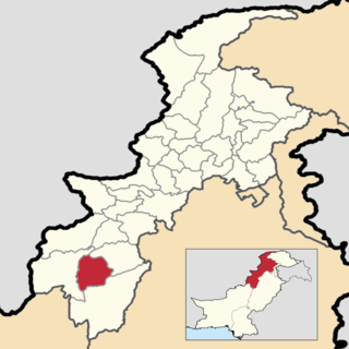
Tank District is a district in Dera Ismail Khan Division of Khyber Pakhtunkhwa province in Pakistan. The city of Tank is the capital of the district, which consists of Union Council City I and Union Council City II. There are sixteen Union councils of district Tank. Until 1992 Tank was a tehsil within Dera Ismail Khan District. Tank is bounded by the districts of Lakki Marwat to the northeast, Dera Ismail Khan to the east and southeast, FR Tank to the north and the South Waziristan Agency to the west. The climate in Tank reaches 110–120 °F. However, in the cold, harsh winters in the mountains to the west, people come to Tank to enjoy a pleasant stay and then return during the summer.
Sohawa is one of the major towns in Mandi Bahauddin District in Punjab, Pakistan. It is situated on the Phalia Road, almost 3 km out of the city of Mandi Bahauddin. It basically consists of three villages: Sohawa Bolani, Sohawa Jamlani and Sohawa Dilloana and is divided into two Union Councils, Sohawa Bolani(17) and Sohawa Dilloana(18).
Garlat is a village and union council of Mansehra District in the Khyber-Pakhtunkhwa province of Pakistan. It is located in Balakot tehsil and lies in an area that was affected by the 2005 Kashmir earthquake.
Kot Gullah is a village and union council, an administrative subdivision, of Chakwal District in the Punjab Province of Pakistan, it is part of Lawa Tehsil.
Trag is a village and Union Council of Mianwali District in the Punjab province of Pakistan. It is in Isakhel tehsil, and is one of the populated villages in the Mianwali District.
Darra Pezu is a town and union council of Lakki Marwat District in Khyber Pakhtunkhwa province of Pakistan. It is located at 32°19'22N 70°44'4E and has an altitude of 316 metres.
Ghazni Khel is the third tehsil of lakki marwat and town and union council of Lakki Marwat District in Khyber Pakhtunkhwa province of Pakistan. It is located at 32°33'30N 70°44'22E and has an altitude of 287 metres. It is located on 20 km Distance From Its District Head Quaters Lakki Marwat.
Bazar Ahmed Khan is a town and union council of Bannu District in Khyber Pakhtunkhwa province of Pakistan. It is located at 32°59'6N 70°38'32E and has an altitude of 344 metres.
Hind Khel Wazir or Hindi Khel is a town and union council of Bannu District in Khyber Pakhtunkhwa province of Pakistan. It is located at 32°47'38N 70°30'29E and has an altitude of 327 metres (1076 feet).
Kakki 1 is a town and union council of Bannu District in Khyber Pakhtunkhwa province of Pakistan. It is located at 32°52'11N 70°40'12E and has an altitude of 308 metres (1,010 ft).
Muhammad Khel is a town and union council in Bannu District of Khyber-Pakhtunkhwa. It is located at 32°58'60N 70°31'60E and has an altitude of 369 metres.
Nar Jaffar Khan is a town and union council in Bannu District of Khyber-Pakhtunkhwa, Pakistan. It is located at 32°51'34N 70°44'4E and has an altitude of 290 metres.
Giloti is a town and union council in the Dera Ismail Khan District of Khyber-Pakhtunkhwa. It is located at 32°9'53N 70°45'2E and has an altitude of 180 metres.
Paharpur is a town of Dera Ismail Khan District in Khyber Pakhtunkhwa, Pakistan. The town is the headquarters of Paharpur Tehsil, an administrative subdivision of the district, and is a Union Council. It is located at 32°6'8N 70°58'12E and has an altitude of 173 metres.

Lakhani is a town and union council of Dera Ghazi Khan District in the Punjab province of Pakistan. The town is part of Taunsa Tehsil. It is located at 30°57'55N 70°33'55E and has an altitude of 181 metres.

Kandwal is a village and [[Field office of Tehsil pind dadan khan Jhelum District in Punjab province of Pakistan Four Town Name Jethal, Dhudhi Thal, Kundal and also Dhok khanga include in field office kandwal Major cast in the region is Khokhar and mostly they are Qutab Shahi Khokhar famous tomb kakina wali sarkar situated in Dhudhi Thal kohistan e nimak died from Kandwal The village has a population of about 30,000.
Kotla Mughlan is a union council of Jampur Tehsil, Rajanpur District, Pakistan.
Sherakot is an administrative unit, known as Union council of Kohistan District in the Khyber Pakhtunkhwa province of Pakistan.
Uttar is an administrative unit, known as Union council, of Tank District in the Khyber Pakhtunkhwa province of Pakistan.
Gomal is an administrative unit, known as Union council, of Tank District in the Khyber Pakhtunkhwa province of Pakistan. Union Council sarangzuna, parts of dabara union council namely Garwaki, Kot Hakim, Jatta Qila and union council Gomal combined form Gomal valley, commonly referred to as Gomal Ilaqa or Gomal Valley. Gomal valley share its borders with South Waziristan Agency in the west, FR Tank in the north, FR D.I.Khan In the south, D.I.Khan in the south east and Tank in the north East. There are two rivers that run through Gomal Valley namely Gomal river and Narsis River. Khand Wand, a small river, separates from Gomal River at Baikarah (sarangzuna) and falls into narsis river a couple of kilometers to the north of Jatta Qila. Gomal Valley comprises several village, including Garwaki, Gomal Bazar, Kot Nawaz, Kot Murtaza, Kot Azam, Kot Khadak and Kot Hakim. Villages of Raghza and Kot Manjhi reside on the southern side of Gomal river while Narsis reside on the northern side of Narsis River. The rest of the villages lie in the green land between the two rivers. Gomal Valley is known for its green and fertile fields. Wheat, Sugar cane, Rice are grown abundantly. Grapes, oranges, apple, and pomegranate are also grown. Gomal valley has a high density of trees.