Palgrave, Suffolk

Last updated

Palgrave
Palgrave Village Green - geograph.org.uk - 340644.jpg
Palgrave Village Green
Suffolk UK location map.svg
Red pog.svg
Palgrave
Location within Suffolk
Population905 (2011 Census)
Civil parish
  • Palgrave
District
  • Mid Suffolk
Shire county
Region
Country England
Sovereign state United Kingdom
Post town DISS
Postcode district IP22
Dialling code 01379
Police Suffolk
Fire Suffolk
Ambulance East of England
UK Parliament
List of places
UK
England
Suffolk
52°21′47″N1°06′27″E / 52.36298°N 1.10756°E / 52.36298; 1.10756

Palgrave is a village and civil parish in the Mid Suffolk district of Suffolk in eastern England. [1] It is located on the south bank of the River Waveney, opposite Diss in Norfolk and adjacent to the Great Eastern Main Line.

Contents

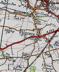
Palgrave has a small primary school, with St Peter’s Church located opposite, and is situated approximately 1 mile from Diss. It also has a green, park, pond, and cemetery.

Palgrave had a population of 905 people in 366 households, according to the 2011 Census. [2]

Palgrave shares a significant historical link with its West/East road linking Great Yarmouth in Norfolk and Bury St Edmunds in Suffolk in the Domesday period (circa 1086).

History

In the 1870s, Palgrave was described as:

"Palgrave, a village and a parish in Hartismere district, Suffolk. The village stands near the boundary with Norfolk, 1 mile S w of Diss r. station, and 4 N W of Eye; and has a Wall letter-box under Diss. The parish comprises 1, 474 acres. Real property, £3, 601. Pop., 739. Houses, 160". [3]

The Occupational Structure of Palgrave, Suffolk 1881 Palgrave Occupational Structure 1881.jpg
The Occupational Structure of Palgrave, Suffolk 1881

The most common occupation found in Palgrave was agriculture, acquired by men over the age of 20 years in 1881. This particular region was found to be ideal for agricultural purposes, due to its location near the River Waverney being a direct source of water. [4] Comparatively, the female population of Palgrave in 1881 shared large proportion of occupations surrounding the domestic and professional roles in the society, accounting for 70% in the professional industry alone as shown in the graph present. [5]

A 20th Century Boundary Map of Palgrave, Suffolk. 20th Century Boundary Map of Palgrave.PNG
A 20th Century Boundary Map of Palgrave, Suffolk.

However, there is a significant amount of the population of Palgrave that has an unknown occupation, accounting for 17.4% of the total population (124 people) in 1881. [6] This unknown occupational data would make it difficult to establish the overall class of the Palgrave, however it could be understood that the local society around 1881 was of a lower, working class, due to the large proportion of occupations being in labour roles such as agriculture, domestic and craftsmanship.

Demographics

The ethnic composition of Palgrave is largely dominated by the ethnic group listed as 'White; English/Welsh/Scottish/Northern Irish/British', with 871 (96.2%) of the population falling under this category. This is followed by the second most prominent ethnic group listed as 'White; Other White' with 21 (2.3%) of the population. The other ethnic groups in Palgrave could be classed as minorities, which include White; Irish (0.3%), Mixed/Multiple Ethnic Groups; White and Black Caribbean (0.1%), Mixed/Multiple Ethnic Groups; White and Asian (0.5%), Asian/Asian British (0.3%); Other Asian and Black/African/Caribbean/Black British; Caribbean (0.1%). [7]

Total Population of Palgrave Civil Parish, Suffolk, as reported by the Census of Population from 1881 to 2011 Palgrave Population Time Series 1811-2011.jpg
Total Population of Palgrave Civil Parish, Suffolk, as reported by the Census of Population from 1881 to 2011

As the neighbouring graph identifies, the total population of Palgrave from 1811 has fluctuated slightly, but has shown a gradual increase in population from 580 (1811) to 905 (2011). [8] It is clear that a slight dip in the 1961 period saw a rapid increase in the population till 2011 where it reached its peak of 905 people.

There are few religions in Palgrave, with the main religion being Christianity accounting for 62.3% (561 people) of the total population. This is followed by 257 people (28.3%) classed under the 'No Religion' category collated by the 2011 census. [9]

Education

Palgrave has one primary school, Palgrave Church of England Voluntary Controlled Primary School. [10] It has a total of 46 mixed gender pupils ranging from 4–11 years old. Although it is smaller than the average sized primary school, they use the supplements of Palgrave's local community centre, Church and village green to pursue in various activities. Ofsted have classed Palgrave Church of England Voluntary Controlled Primary School as a 'Good' school, when it was last inspected in May 2012. [11]

Transport and housing

There is a total of 378 dwellings in Palgrave according to the 2011 Census report. [12] This is a significant increase when comparing it with the data from 1831, where only 99 households were present in the parish. [13] This increase in housing correlates with the total population increase shown in the graph above, therefore the increase of people living in Palgrave encouraged more houses to be built in the area to satisfy the increasing population.

Palgrave is situated around 1.6 miles from the nearest railway station, which is at Diss. Bus services are operated by Botesdate Parish Council and run once a week, with services towards Diss railway station. [14]

See also

Related Research Articles

<span class="mw-page-title-main">Rickinghall Inferior</span> Human settlement in England

Rickinghall Inferior is a civil parish in the Mid Suffolk district of Suffolk, England. According to the 2011 census there were 233 males and 216 females in this civil parish, for a total population of 449. It includes the western part of the village of Rickinghall and is adjacent to the village and parish of Wattisfield. The old road from the market town of Bury. St Edmunds to the City of Norwich and the town of Great Yarmouth passes through the centre of the village but the new road, the A143, uses a by-pass to the East.

<span class="mw-page-title-main">Ripple, Kent</span> Human settlement in England

Ripple, also known as 'Ripple Vale', is a village and civil parish in the Dover District of Kent, England.

<span class="mw-page-title-main">Badingham</span> Human settlement in England

Badingham is a civil parish in the East Suffolk district of eastern England, in the county of Suffolk. It is situated 21.8 miles north east of Ipswich, 35 miles (56 km) away from Norwich and 13 miles (21 km) away from the coast. With the road "A1120" slicing through the middle of the parish. Badingham's name is Anglo-Saxon and means "the farmstead of Bada’s people". Badingham contains a significant number of farms, sparse amount of housing, numerous B&Bs as well as St. John's Church.

<span class="mw-page-title-main">Belstead</span> Human settlement in England

Belstead is a village and civil parish in the Babergh district of the English county of Suffolk. Located on the southern edge of Ipswich, around 3 miles (5 km) south-west of Ipswich town centre. It had a population of 202 according to the 2011 census. Belstead has amenities such as a village hall, St Mary's the Virgin Church, The bridge school for children with learning difficulties and Belstead Brook Hotel and Spa. It is in the Belstead Brook electoral division of Suffolk County Council.

<span class="mw-page-title-main">Knodishall</span> Village in Suffolk, England

Knodishall, a village in Suffolk, England, lies 3.5 miles (6 km) south-east of Saxmundham, 1 mile (2 km) south-west of Leiston, and 3 miles from the coast, in the Blything Hundred. Most dwellings are now at Coldfair Green; just a few remain in the original village by the parish Church of St Lawrence, which falls gently on the north side of the Hundred River valley. It is now an outlier of Knodishall Common, a settlement a mile to the south-east. The estimated parish population was 790 in 2019.

<span class="mw-page-title-main">Darenth</span> Human settlement in England

Darenth is a village and civil parish in the Borough of Dartford, Kent, England. It is located 3.4 miles south east of Dartford and 4.6 miles north east of Swanley.

<span class="mw-page-title-main">Parham, Suffolk</span> Village and civil parish in Suffolk, England

Parham is a village and civil parish in the East Suffolk district of Suffolk in eastern England. Located seven miles north of Woodbridge, in 2005 it had a population of 300, reducing to 263 at the 2011 census and according to the 2011 census there were 129 males and 134 females living at this time.

<span class="mw-page-title-main">Tingrith</span> Human settlement in England

Tingrith is a small village and civil parish in Bedfordshire, England. It is located adjacent to the M1 motorway near the large village of Toddington. The nearest major town is Luton, located about 10 miles (16 km) to the southeast. The parish church of St Nicholas dates back to the 13th century and has Tingrith's only cemetery. The church can seat up to 200 people.

<span class="mw-page-title-main">Wacton, Norfolk</span> Human settlement in England

Wacton is a village in the English county of Norfolk. It is located about one mile south-west of Long Stratton and 13 miles (21 km) south west of Norwich. It covers an area of 4.54 km2 (1.75 sq mi) and has a population of 302 people as of the last census in 2011

<span class="mw-page-title-main">Heveningham</span> Village in Suffolk, England

Heveningham is a village and civil parish in the East Suffolk district of Suffolk in eastern England. Located four miles south-west of Halesworth, in 2005 it had a population of 120.

Wetheringsett-cum-Brockford is a civil parish in the Mid Suffolk district of Suffolk in eastern England. The parish contains the village of Wetheringsett, together with the hamlets of Blacksmith's Green, Broad Green, Brockford Street, Brockford Green, Knaves Green, Page's Green, Park Green, Pitman's Corner, Wetherup Street and White Horse Corner. In the 2011 census, the population was 669. Wetheringsett-cum-Brockford is home to the All Saints Church and the Wetheringsett Church of England Voluntary Controlled Primary School. The parish also contains 55 listed buildings.

<span class="mw-page-title-main">Worlingworth</span> Village in Suffolk, England

Worlingworth is a village and civil parish in the Mid Suffolk district of Suffolk in eastern England, located around ten miles south-east of Diss. In 2011 it had a total population of 802 people.

<span class="mw-page-title-main">Fakenham Magna</span> Human settlement in England

Fakenham Magna is a village and civil parish in the West Suffolk district of Suffolk in eastern England. The meaning of the word 'Fakenham' can be split into two: 'Faken' and 'ham', both of which derive from Old English. The former refers to somebody by the name of 'Facca', with the latter meaning 'a village / a homestead', making the direct translation 'Facca's homestead'. 'Magna' translates from Latin as 'great', hence the alternative name of the village of 'Great Fakenham'. During World War Two, however, the village was referred to as 'Little Fakenham', which was used to avoid confusion with the larger civil parish of Fakenham in Norfolk.

<span class="mw-page-title-main">Great Moulton</span> Human settlement in England

Great Moulton is a civil parish in the English county of Norfolk. Until the 16th century it also included the Little Moulton parish.

<span class="mw-page-title-main">Roudham and Larling</span> Human settlement in England

Roudham and Larling is a civil parish in the English county of Norfolk. It includes the villages of Roudham and Larling. It covers an area of 15.20 km2 (5.87 sq mi) and had a population of 278 in 119 households at the 2001 census, increasing to a population of 301 in 119 households at the 2011 Census. For the purposes of local government, it falls within the district of Breckland. River Thet flows next to Roudham and Larling.

<span class="mw-page-title-main">Stanfield, Norfolk</span> Human settlement in England

Stanfield is a civil parish in the English county of Norfolk. It covers an area of 3.80 km2 (1.47 sq mi) and had a population of 162 in 2011, and 144 at the 2001 census. For the purposes of local government, it falls within the district of Breckland. Stanfield belongs to the Parliamentary Constituency of Mid-Norfolk and is currently governed by George Freeman as their member of Parliament who is representative of the Conservative Party.

<span class="mw-page-title-main">Kirton, Suffolk</span> Human settlement in England

Kirton is a village and a civil parish in the shire county of Suffolk, England, situated off the A14 road, about 4.5 km (2.8 mi) from Felixstowe and around 10 km (6.2 mi) from Ipswich. The closest train station to Kirton is Trimley. According to the 2011 census, Kirton had a population of 1,146. It is located between the River Deben and the River Orwell. The village of Kirton covers a total area of 8.3 km2 (3.2 sq mi). As the county of Suffolk lacks quarries, many of the buildings are made from flint, clay and timber.

<span class="mw-page-title-main">Walpole, Suffolk</span> Human settlement in England

Walpole is a small village and civil parish in the district of East Suffolk in Suffolk, England. Walpole has a parish church, a redundant chapel, but the primary school has closed. The village is on the River Blyth. Nearby settlements include the town of Halesworth and the village of Cookley. It was in the hundred of Blything. It had a population of 238 according to the 2011 census.

<span class="mw-page-title-main">Roxwell</span> Human settlement in England

Roxwell is a village and civil parish in the Chelmsford district of Essex, England. The village is approximately 4 miles (6 km) west from the centre of the county town of Chelmsford, and to the south of the A1060 road, on which are the parish hamlets of Boyton Cross and Chalk End. Further Roxwell hamlets are Peppers Green at the north of the parish and Radley Green at the south.

<span class="mw-page-title-main">Eyke</span> Human settlement in England

Eyke is a village and a civil parish in the East Suffolk district, in the English county of Suffolk. It is located on the A1152 road near the town of Woodbridge. Eyke has a primary school, the manor house of Lord and Lady Lucas with scenic pond and horse paddock, and a pub. The mediaeval parish church of All Saints was restored in the 1860s. Services are normally held on the first and third Sundays of the month.

References

  1. Kelly, E. R., ed. (1875). "Palgrave". The Post Office Directory of Cambridge, Norfolk and Suffolk. London: Kelly & Co. p. 895.
  2. "Palgrave: Key Figures for 2011 Census: Key Statistics". Neighbourhood Statistics. Parish: Office for National Statistics. Retrieved 24 April 2016.
  3. Wilson, John Marius (1870–72). Imperial Gazetteer of England and Wales. Edinburgh: A. Fullerton & Co.
  4. Palgrave. The National Gazetteer of Great Britain and Ireland. 1868.
  5. "Occupation data classified into the 24 1881 'Orders', plus sex". A Vision of Britain Through Time. Retrieved 25 April 2016.
  6. "Occupation data classified into the 24 1881 'Orders', plus sex". A Vision of Britain Through Time. 1881. Retrieved 25 April 2016.
  7. "Ethnic Group, 2011". Office for National Statistics. 2011. Retrieved 25 April 2016.
  8. "Key Figures for 2011 Census: Key Statistics". Office for National Statistics. 2011. Retrieved 25 April 2016.
  9. "Religion, 2011". Office for National Statistics. 2011. Retrieved 25 April 2016.
  10. "Palgrave CEVC Primary School Homepage". Palgrave CEVC Primary School. Retrieved 25 April 2016.
  11. "Palgrave Church of England Voluntary Controlled Primary School". Ofsted. 1–2 May 2012. Retrieved 25 April 2016.
  12. "Key Figures for Housing". Office for National Statistics. 2011. Retrieved 25 April 2016.
  13. "Total Houses". A Vision of Britain through Time. Retrieved 25 April 2016.
  14. "304/338 Botesdale Parish Council". Botesdale Parish Council. Retrieved 25 April 2016.