Palmares | |
|---|---|
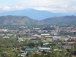 Skyline of Palmares | |
 Palmares district | |
 Palmares Palmares district location in Costa Rica | |
| Coordinates: 10°03′19″N84°25′58″W / 10.055229°N 84.4326974°W | |
| Country | |
| Province | Alajuela |
| Canton | Palmares |
| Area | |
• Total | 1.14 km2 (0.44 sq mi) |
| Elevation | 1,017 m (3,337 ft) |
| Population (2011) | |
• Total | 3,599 |
| • Density | 3,200/km2 (8,200/sq mi) |
| Time zone | UTC−06:00 |
| Postal code | 20701 |
Palmares is a district of the Palmares canton, in the Alajuela province of Costa Rica. [1] [2]