
San José is the capital and largest city of Costa Rica, and the capital of the province of the same name. It is in the center of the country, in the mid-west of the Central Valley, within San José Canton. San José is Costa Rica's seat of national government, focal point of political and economic activity, and major transportation hub. San José is simultaneously one of Costa Rica's cantons, with its municipal land area covering 44.62 square kilometers and having within it an estimated population of 352,381 people in 2022. Together with several other cantons of the central valley, including Alajuela, Heredia and Cartago, it forms the country's Greater Metropolitan Area, with an estimated population of over 2 million in 2017. The city is named in honor of Joseph of Nazareth.

Escazú is the second canton in the province of San José in Costa Rica.
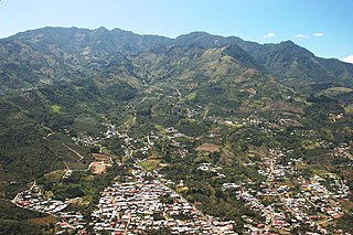
Desamparados is the 3rd canton in the province of San José in Costa Rica. The canton covers an area of 118.89 km2 (45.90 sq mi), and had a population of 223,226 in 2022, making it the third most populated among the 81 cantons of Costa Rica. The canton's capital city is also called Desamparados.

San Carlos is a canton in the Alajuela province of Costa Rica. The capital city of the canton is Ciudad Quesada.
Pococí is a canton in the Limón province of Costa Rica. The head city is in Guápiles district, which houses many of the canton's services and businesses.

Costa Rica is administratively divided into seven provinces which are subdivided into 84 cantons, and these are further subdivided into districts. Cantons are the only administrative division in Costa Rica that possess local government in the form of municipalities. Each municipality has its own mayor and several representatives, all of them chosen via municipal elections every four years.

Poás is a canton in the Alajuela province of Costa Rica. The head city of the canton is San Pedro.

Cartago is a canton in the Cartago province of Costa Rica. The head city is Cartago.

Heredia is a canton in the Heredia province of Costa Rica. The head city is in Heredia district, and is also the provincial capital of Heredia Province.
Pérez Zeledón is the nineteenth canton of the province of San José in Costa Rica, located in the Brunca region. The capital city of the canton is San Isidro de El General.

Santa Ana is the ninth canton in the San José province of Costa Rica. It is located in the Central Valley. It borders with the Alajuela canton to the north, the Mora canton to the south and west, the Escazú canton to the east, as well as the Belén canton to the north east. As of 2022, the canton has the highest Human Development Index of any region in Costa Rica with a score of 0.871.
Goicoechea is a canton in the San José province of Costa Rica.
Aserrí is the sixth canton in the San José province of Costa Rica. The head city of the canton is the homonymous Aserrí.
San Pedro is a district of the Poás canton, in the Alajuela province of Costa Rica.
Quitirrisí is a district of the Mora canton, in the San José province of Costa Rica.
Sabanilla is a district of the Alajuela canton, in the Alajuela province of Costa Rica.
San Juan is a district of the Poás canton, in the Alajuela province of Costa Rica.
San Rafael is a district of the Poás canton, in the Alajuela province of Costa Rica.
Carrillos is a district of the Poás canton, in the Alajuela province of Costa Rica.
Sabana Redonda is a district of the Poás canton, in the Alajuela province of Costa Rica.


