Naranjo | |
|---|---|
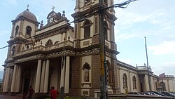 Naranjo Church | |
 Flag  Seal | |
 Naranjo canton | |
 Naranjo Naranjo canton location in Alajuela Province  Naranjo Naranjo canton location in Costa Rica | |
| Coordinates: 10°06′19″N84°23′19″W / 10.1052938°N 84.3885279°W | |
| Country | |
| Province | Alajuela |
| Creation | 9 March 1886 [1] |
| Head city | Naranjo |
| Districts | |
| Government | |
| • Type | Municipality |
| • Body | Municipalidad de Naranjo |
| Area | |
• Total | 126.62 km2 (48.89 sq mi) |
| Elevation | 1,121 m (3,678 ft) |
| Population (2011) | |
• Total | 42,713 |
| • Density | 340/km2 (870/sq mi) |
| Time zone | UTC−06:00 |
| Canton code | 206 |
| Website | www |
Naranjo is a canton in the Alajuela province of Costa Rica. [2] [3] The head city is located in the homonymous Naranjo district.