Heredia (canton)

Last updated
Heredia
Rn-d1533-gfdl.jpg
Inmaculada Concepción Church, Heredia
Bandera de la Provincia de Heredia.svg
Coat of arms of Heredia.svg
Heredia (canton)
Heredia canton
Costa Rica location map.svg
Red pog.svg
Heredia
Heredia canton location in Costa Rica
Coordinates: 10°07′44″N84°02′31″W / 10.1289028°N 84.0419806°W / 10.1289028; -84.0419806 Coordinates: 10°07′44″N84°02′31″W / 10.1289028°N 84.0419806°W / 10.1289028; -84.0419806
Country Flag of Costa Rica.svg  Costa Rica
Province Heredia
Creation7 December 1848 [1]
Head city Heredia
Districts
Government
  Type Municipality
  BodyMunicipalidad de Heredia
Area
  Total282.6 km2 (109.1 sq mi)
Elevation
1,242 m (4,075 ft)
Population
 (2011)
  Total123,616
  Density440/km2 (1,100/sq mi)
Time zone UTC−06:00
Canton code401
Website www.heredia.go.cr/en

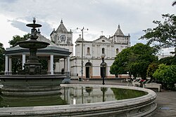
Heredia is a canton in the Heredia province of Costa Rica. [2] [3] The head city is in Heredia district, and is also the provincial capital of Heredia Province.

Contents

History

Heredia was created on 7 December 1848 by decree 167. [1]

Geography

Heredia has an area of 282.6 km² [4] and a mean elevation of 1,242 metres. [2]

The canton includes the areas south and west of the capital city of Heredia as far as the Virilla River and the National Route 1.

The non-contiguous district of Varablanca, that includes a large portion of Braulio Carrillo National Park high in the Cordillera Central, is also administered as part of Heredia Canton.

Districts

The canton of Heredia is subdivided into the following districts:

  1. Heredia
  2. Mercedes
  3. San Francisco
  4. Ulloa
  5. Varablanca

Demographics

Historical population
CensusPop.
1864 14,073
1883 16,45216.9%
1892 16,4800.2%
1927 12,667−23.1%
1950 19,89857.1%
1963 30,91955.4%
1973 36,48718.0%
1984 54,89650.5%
2000 103,89489.3%
2011 123,61619.0%

Instituto Nacional de Estadística y Censos [5]
Centro Centroamericano de Población [6]

For the 2011 census, Heredia had a population of 123,616 inhabitants. [7]

Transportation

Road transportation

The canton is covered by the following road routes:

Rail transportation

The Interurbano Line operated by Incofer goes through this canton.

Related Research Articles

Santo Domingo, Costa Rica Canton in Heredia province, Costa Rica

Santo Domingo is a canton in the Heredia province of Costa Rica. The head city of the canton is the homonymous Santo Domingo district.

San Rafael (canton) Canton in Heredia province, Costa Rica

San Rafael is a canton in the Heredia province of Costa Rica. The head city is in San Rafael district.

Flores (canton) Canton in Heredia province, Costa Rica

Flores is a canton in the Heredia province of Costa Rica. The head city is in San Joaquín district.

Varablanca District in Heredia canton, Heredia province, Costa Rica

Varablanca is a district of the Heredia canton, in the Heredia province of Costa Rica.

Santiago District, San Rafael District in San Rafael canton, Heredia province, Costa Rica

Santiago is a district of the San Rafael canton, in the Heredia province of Costa Rica.

Mercedes District, Heredia District in Heredia canton, Heredia province, Costa Rica

Mercedes is a district of the Heredia canton, in the Heredia province of Costa Rica.

San Francisco District, Heredia District in Heredia canton, Heredia province, Costa Rica

San Francisco is a district of the Heredia canton, in the Heredia province of Costa Rica.

Ulloa District District in Heredia canton, Heredia province, Costa Rica

Ulloa is a district of the Heredia canton, in the Heredia province of Costa Rica.

San Pablo District, Barva District in Barva canton, Heredia province, Costa Rica

San Pablo is a district of the Barva canton, in the Heredia province of Costa Rica.

San Roque District, Barva District in Barva canton, Heredia province, Costa Rica

San Roque is a district of the Barva canton, in the Heredia province of Costa Rica.

San Vicente District, Santo Domingo District in Santo Domingo canton, Heredia province, Costa Rica

San Vicente is a district of the Santo Domingo canton, in the Heredia province of Costa Rica.

San Miguel District, Santo Domingo District in Santo Domingo canton, Heredia province, Costa Rica

San Miguel is a district of the Santo Domingo canton, in the Heredia province of Costa Rica.

Paracito District in Santo Domingo canton, Heredia province, Costa Rica

Paracito is a district of the Santo Domingo canton, in the Heredia province of Costa Rica.

Santo Tomás District, Santo Domingo District in Santo Domingo canton, Heredia province, Costa Rica

Santo Tomás is a district of the Santo Domingo canton, in the Heredia province of Costa Rica.

Santa Rosa District, Santo Domingo District in Santo Domingo canton, Heredia province, Costa Rica

Santa Rosa is a district of the Santo Domingo canton, in the Heredia province of Costa Rica.

Ángeles District, San Rafael District in San Rafael canton, Heredia province, Costa Rica

Ángeles is a district of the San Rafael canton, in the Heredia province of Costa Rica.

San José District, San Isidro District in San Isidro canton, Heredia province, Costa Rica

San José is a district of the San Isidro canton, in the Heredia province of Costa Rica.

San Antonio District, Belén District in Belén canton, Heredia province, Costa Rica

San Antonio is a district of the Belén canton, in the Heredia province of Costa Rica.

Barrantes District District in Flores canton, Heredia province, Costa Rica

Barrantes is a district of the Flores canton, in the Heredia province of Costa Rica.

Llorente District District in Flores canton, Heredia province, Costa Rica

Llorente is a district of the Flores canton, in the Heredia province of Costa Rica.

References

  1. 1 2 Hernández, Hermógenes (1985). Costa Rica: evolución territorial y principales censos de población 1502 - 1984 (in Spanish) (1 ed.). San José: Editorial Universidad Estatal a Distancia. pp. 164–173. ISBN   9977-64-243-5 . Retrieved 5 October 2020.
  2. 1 2 "Declara oficial para efectos administrativos, la aprobación de la División Territorial Administrativa de la República N°41548-MGP". Sistema Costarricense de Información Jurídica (in Spanish). 19 March 2019. Retrieved 26 September 2020.
  3. División Territorial Administrativa de la República de Costa Rica (PDF) (in Spanish). Editorial Digital de la Imprenta Nacional. 8 March 2017. ISBN   978-9977-58-477-5.
  4. "Área en kilómetros cuadrados, según provincia, cantón y distrito administrativo". Instituto Nacional de Estadística y Censos (in Spanish). Retrieved 26 September 2020.
  5. "Instituto Nacional de Estadística y Censos" (in Spanish).
  6. "Sistema de Consulta de a Bases de Datos Estadísticas". Centro Centroamericano de Población (in Spanish).
  7. "Censo. 2011. Población total por zona y sexo, según provincia, cantón y distrito". Instituto Nacional de Estadística y Censos (in Spanish). Retrieved 26 September 2020.