Orotina (canton)

Last updated
Orotina
Orotina Pavilion. Costa Rica.JPG
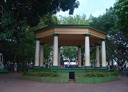
Orotina Central Park
Bandera de Orotina (Costa Rica).svg
Escudo del Canton de Orotina.png
Orotina (canton)
Orotina canton
Costa Rica Alajuela location map.svg
Red pog.svg
Orotina
Orotina canton location in Alajuela Province
Costa Rica location map.svg
Red pog.svg
Orotina
Orotina canton location in Costa Rica
Coordinates: 9°53′33″N84°34′33″W / 9.8926261°N 84.5757166°W / 9.8926261; -84.5757166
Country Flag of Costa Rica.svg  Costa Rica
Province Alajuela
Creation1 August 1908 [1]
Head city Orotina
Districts
Government
  Type Municipality
  BodyMunicipalidad de Orotina
Area
  Total
141.92 km2 (54.80 sq mi)
Elevation
198 m (650 ft)
Population
 (2011)
  Total
20,341
  Density140/km2 (370/sq mi)
Time zone UTC−06:00
Canton code209
Website muniorotina.go.cr

Orotina is a canton in the Alajuela province of Costa Rica. [2] [3] The head city of the canton is also called Orotina.

Contents

History

Orotina was created on 1 August 1908 by decree 39. [1]

Geography

Orotina has an area of 141.92 km² [4] and a mean elevation of 198 metres. [2]

The canton lies on the western side of the Coastal Mountain Range between the Jesús María River and Machuca River on the north and the Grande de Tárcoles River on the south.

Districts

The canton of Orotina is subdivided into the following districts:

  1. Orotina
  2. El Mastate
  3. Hacienda Vieja
  4. Coyolar
  5. La Ceiba

Demographics

Historical population
Census Pop.±% p.a.
19274,151    
19505,951+1.58%
19637,093+1.36%
19738,479+1.80%
198410,494+1.96%
200015,705+2.55%
201120,341+2.38%
202224,217+1.60%
Source: Instituto Nacional de Estadística y Censos [5]
Centro Centroamericano de Población [6]

For the 2011 census, Orotina had a population of 20,341 inhabitants. [7]

Transportation

Road transportation

The canton is covered by the following road routes:

References

  1. 1 2 Hernández, Hermógenes (1985). Costa Rica: evolución territorial y principales censos de población 1502 - 1984 (in Spanish) (1 ed.). San José: Editorial Universidad Estatal a Distancia. pp. 164–173. ISBN   9977-64-243-5 . Retrieved 5 October 2020.
  2. 1 2 "Declara oficial para efectos administrativos, la aprobación de la División Territorial Administrativa de la República N°41548-MGP". Sistema Costarricense de Información Jurídica (in Spanish). 19 March 2019. Retrieved 26 September 2020.
  3. División Territorial Administrativa de la República de Costa Rica (PDF) (in Spanish). Editorial Digital de la Imprenta Nacional. 8 March 2017. ISBN   978-9977-58-477-5.
  4. "Área en kilómetros cuadrados, según provincia, cantón y distrito administrativo". Instituto Nacional de Estadística y Censos (in Spanish). Retrieved 26 September 2020.
  5. "Instituto Nacional de Estadística y Censos" (in Spanish).
  6. Centro Centroamericano de Población de la Universidad de Costa Rica. "Sistema de Consulta a Bases de Datos Estadísticas" (in Spanish).
  7. "Censo. 2011. Población total por zona y sexo, según provincia, cantón y distrito". Instituto Nacional de Estadística y Censos (in Spanish). Retrieved 26 September 2020.