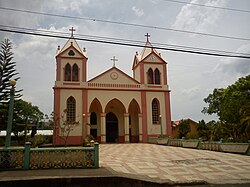
San Mateo | |
---|---|
Coordinates: 9°57′38″N84°33′37″W / 9.9605539°N 84.560288°W | |
Country | Costa Rica |
Province | Alajuela |
Creation | 7 August 1868 [1] |
Head city | San Mateo |
Districts | Districts |
Government | |
• Type | Municipality |
• Body | Municipalidad de San Mateo |
Area | |
• Total | 125.9 km2 (48.6 sq mi) |
Elevation | 311 m (1,020 ft) |
Population (2011) | |
• Total | 6,136 |
• Density | 49/km2 (130/sq mi) |
Time zone | UTC−06:00 |
Canton code | 204 |
Website | {{ URL |example.com|optional display text}} |
San Mateo is a canton in the Alajuela province of Costa Rica. [2] [3] The head city is in San Mateo district.
San Mateo was created on 7 August 1868 by decree 30. [1]
San Mateo has an area of 125.9 km² [4] and a mean elevation of 311 metres. [2]
The northern border of the elongated province is formed by the Jesús María, Machuca, Agua Agría, Calera rivers and Quebrada Zapote. The Quebrada Concepción, Grande de Tárcoles and the Machuca rivers establish the southern border. Cerro La Lana is a landmark that delineates a northeast tip of the canton.
The canton of San Mateo is subdivided into the following districts:
Historical population | |||
---|---|---|---|
Census | Pop. | %± | |
1864 | 1,682 | — | |
1883 | 2,525 | 50.1% | |
1892 | 3,353 | 32.8% | |
1927 | 3,234 | −3.5% | |
1950 | 3,611 | 11.7% | |
1963 | 3,388 | −6.2% | |
1973 | 2,969 | −12.4% | |
1984 | 3,783 | 27.4% | |
2000 | 5,343 | 41.2% | |
2011 | 6,136 | 14.8% | |
Instituto Nacional de Estadística y Censos [5] |
For the 2011 census, San Mateo had a population of 6,136 inhabitants. [7]
The canton is covered by the following road routes:
Tibás is the thirteenth canton in the province of San José in Costa Rica. The head city of the canton is San Juan.
Orotina is a canton in the Alajuela province of Costa Rica. The head city of the canton is also called Orotina.
Mora is the seventh canton in the San José province of Costa Rica.
Tilarán is a canton in the Guanacaste province of Costa Rica. The head city is in Tilarán district.
San Mateo is a district of the San Mateo canton, in the Alajuela province of Costa Rica.
Porvenir is a district of the Nandayure canton, in the Guanacaste province of Costa Rica. Located on the Nicoya Peninsula.
Bejuco is a district of the Nandayure canton, in the Guanacaste province of Costa Rica. Located on the Nicoya Peninsula.
Cuajiniquil is a district of the Santa Cruz canton, in the Guanacaste province of Costa Rica.
San Antonio is a district of the Puriscal canton, in the San José province of Costa Rica.
San Josecito is a district of the Alajuelita canton, in the San José province of Costa Rica.
San Luis is a district of the Turrubares canton, in the San José province of Costa Rica.
San Antonio is a district of the Alajuela canton, in the Alajuela province of Costa Rica.
Desmonte is a district of the San Mateo canton, in the Alajuela province of Costa Rica.
Jesús María is a district of the San Mateo canton, in the Alajuela province of Costa Rica.
Labrador is a district of the San Mateo canton, in the Alajuela province of Costa Rica.
San Rafael is a district of the Poás canton, in the Alajuela province of Costa Rica.
San Jorge is a district of the Los Chiles canton, in the Alajuela province of Costa Rica.
Quebrada Honda is a district of the Nicoya canton, in the Guanacaste province of Costa Rica.
Quebrada Grande is a district of the Tilarán canton, in the Guanacaste province of Costa Rica.
Santa Rosa is a district of the Tilarán canton, in the Guanacaste province of Costa Rica.