
Timberline Lodge is a mountain lodge on the south side of Mount Hood in Clackamas County, Oregon, about 60 miles (97 km) east of Portland. Constructed from 1936 to 1938 by the Works Progress Administration, it was built and furnished by local artisans during the Great Depression. Timberline Lodge was dedicated September 28, 1937, by President Franklin D. Roosevelt.

Mount Hood is an active stratovolcano in the Cascade Volcanic Arc. It was formed by a subduction zone on the Pacific coast and rests in the Pacific Northwest region of the United States. It is located about 50 mi (80 km) east-southeast of Portland, on the border between Clackamas and Hood River counties. In addition to being Oregon's highest mountain, it is one of the loftiest mountains in the nation based on its prominence, and it offers the only year-round lift-served skiing in North America.

Snowbird is an unincorporated community in Little Cottonwood Canyon in the Wasatch Range of the Rocky Mountains near Salt Lake City, Utah, United States. It is most famous for Snowbird Ski and Summer Resort, an alpine skiing and snowboarding area, which opened in December 1971.

Alta is a ski area in the western United States, located in the town of Alta in the Wasatch Mountains of Utah, in Salt Lake County. With a skiable area of 2,614 acres (10.58 km2), Alta's base elevation is 8,530 ft (2,600 m) and rises to 11,068 ft (3,374 m) for a vertical gain of 2,538 ft (774 m). One of the oldest ski resorts in the country, it opened its first lift in early 1939. Alta is known for receiving more snow than most Utah resorts, with an average annual snowfall of 545 inches (13.8 m). It is also regularly ranked as having the best snow in North America. Alta is one of three remaining ski resorts in the U.S. that prohibits snowboarders, along with nearby competitor Deer Valley and Vermont's Mad River Glen.

The Mount Hood Wilderness is a protected wilderness area inside the Mount Hood National Forest, in the U.S. state of Oregon. The area, covering 64,742 acres (26,200 ha), includes the peak of Mount Hood and its upper slopes, and ranges from temperate rain forests at the lower elevations, to glaciers and rocky ridges at higher elevations.

Smugglers' Notch Resort is a ski resort area in the town of Cambridge, Vermont, United States, located near the village of Jeffersonville. Its vertical drop of 2,610 feet (800 m) is the fourth largest in New England and the third largest in Vermont. Its namesake is a narrow notch running adjacent to Sterling Mountain, which smugglers used many years ago. Smugglers' Notch, nicknamed Smuggs, consists of three mountains: Morse, Madonna, and Sterling. The resort attracts skiers in the winter and summer vacationers during the warmer months.

Mount Hood Meadows is a ski resort on the southeastern face of Mount Hood in northern Oregon, and is the largest of the mountain's ski resorts. It is located about 67 miles (108 km) east of Portland, and 35 miles (56 km) from Hood River along Oregon Route 35. It has both Alpine and Nordic ski areas and offers night skiing, lessons and equipment rentals. It also has a robust food services department that includes coffee bars, grab and go options, bars, sit down restaurants, and a food court. There are no overnight accommodations at Mount Hood Meadows itself, but both Timberline Lodge and Cooper Spur Resort, two ski areas also on Mount Hood, offer overnight options. Additionally, many buses provide transportation to and from Mount Hood Meadows, including those run by Columbia Gorge Area Transit (CAT). There are also condos in Government Camp.

The Silcox Hut is a small rustic mid-mountain lodge located at 6,950 feet (2,120 m) elevation on Mount Hood, Oregon, United States. It is approximately 1,000 feet (300 m) vertical above Timberline Lodge and roughly one mile distance directly up the mountain.

The Magic Mile is an aerial chairlift at Timberline Lodge ski area, Mount Hood, Oregon, U.S. It was named for its unique location above the tree line and for its original length. When constructed by Byron Riblet in 1938, it was the longest chairlift in existence, the second in the world to be built as a passenger chairlift, and the first to use metal towers.

Timberline Lodge ski area is the ski and snowboarding area of Timberline Lodge, a National Historic Landmark in the U.S. state of Oregon. It is one of a few ski areas in the United States with most of the skiable terrain below the main lodge. It is located on the south face of Mount Hood, about 60 miles (95 km) east of Portland, accessible via the Mount Hood Scenic Byway.

The Zigzag River is a tributary, about 12 miles (19 km) long, of the Sandy River in the U.S. state of Oregon. The Zigzag and one of its major tributaries, the Little Zigzag River, drain the Zigzag Glacier on Mount Hood, a high volcanic peak in the Cascade Range. Their waters flow westward to meet the Sandy River near the community of Zigzag. The river's flow ranges from 200 to 1,000 cubic feet per second.

The Liberty Cap Glacier is a small glacier located near the summit of Mount Rainier, Washington. True to its name, the glacier does start at the 14,100 feet (4,300 m) Liberty Cap above the steep and rocky Sunset Amphitheater and the Mowich Face. Since the topography of Mount Rainier is very jagged and uneven, the glacier is warped and twisted during its descent northward down to its terminus at about 11,000 feet (3,400 m). From there, the glacier ice falls off the cliff and tumbles down the steep Mowich Face; eventually, this ice contributes to the large North Mowich Glacier at an elevation of 10,100 ft (3,100 m).
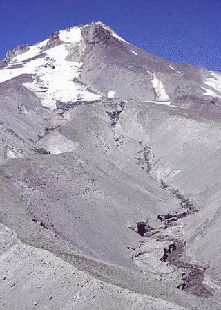
Zigzag Glacier is an alpine glacier located on the upper southwest slopes of Mount Hood in the U.S. state of Oregon. It ranges in elevation from 10,200 to 7,200 feet with fingers in canyons extending to about 6,400 feet (2,000 m), and lies almost entirely within Mount Hood Wilderness. The upper extent is divided from Reid Glacier by Illumination Rock. The top of the glacier is at the foot of Crater Rock.

The Coalman Glacier is a glacier located on the upper slopes of Mount Hood in the U.S. state of Oregon. It is the mountain's highest glacier ranging from about 11,200 to 10,500 ft, located within the crater rim, southwest of the peak. It was named for Elija Coalman, an early mountain guide who climbed Mount Hood 586 times.
Terry Peak is a mountain and ski area in the west central United States, in the Black Hills of South Dakota outside of Lead. With an elevation of 7,064 feet (2,153 m) above sea level, it is the most prominent peak in the Northern Black Hills area, and the sixth highest summit in the range; the tallest is Black Elk Peak at 7,244 feet (2,208 m).
White River Glacier is an alpine glacier located on the south slopes of Mount Hood in the U.S. state of Oregon. It ranges in elevation from about 10,000 to 6,200 feet. It is among the best known of the twelve glaciers on the mountain, and the lower reaches are a popular destination for Nordic skiing enthusiasts. The glacier is the source of the White River, a tributary of the Deschutes River, and has a long history of washing out the bridge where Oregon Route 35 crosses at 45.30307°N 121.67208°W.

Reid Glacier is an alpine glacier located on the west slope of Mount Hood in the U.S. state of Oregon. It ranges in elevation from about 9,800 to 6,000 feet. The glacier is the source of the Sandy River. The upper extent of the glacier is known for extensive crevasses.

Bonanza Peak is a tall peak in the North Cascades in the U.S. state of Washington and the Glacier Peak Wilderness of the Wenatchee National Forest. At 9,516 feet (2,900 m) in elevation, it is the highest point in Chelan County, and the highest non-volcanic peak in Washington. and the Cascade Range as a whole. Bonanza Peak's prominence is 3,711 feet (1,131 m), making it the 26th most prominent peak in Washington. The nearest higher peak is Glacier Peak, 14.4 miles (23.2 km) to the southwest.

The Little Zigzag River is a tributary, about 5 miles (8.0 km) long, of the Zigzag River in the U.S. state of Oregon. The Zigzag and Little Zigzag drain the Zigzag Glacier on Mount Hood, a high volcanic peak in the Cascade Range. Their combined waters flow westward to meet the Sandy River near the community of Zigzag. Little Zigzag Falls, a popular hiking destination, is on the river near U.S. Route 26 east of Zigzag.

Mazama Glacier is located on the southeast slopes of Mount Adams, a stratovolcano in the U.S. state of Washington. Mazama Glacier is in the Yakama Indian Reservation. The glacier descends from approximately 10,800 ft (3,300 m) to a terminus near 7,600 ft (2,300 m). Mazama Glacier has been in a general state of retreat for over 100 years and lost 46 percent of its surface area between 1904 and 2006.


