Mount St. Helens is an active stratovolcano located in Skamania County, Washington, in the Pacific Northwest region of the United States. It is 50 miles (80 km) northeast of Portland, Oregon, and 96 miles (154 km) south of Seattle. Mount St. Helens takes its English name from the British diplomat Lord St Helens, a friend of explorer George Vancouver who made a survey of the area in the late 18th century. The volcano is located in the Cascade Range and is part of the Cascade Volcanic Arc, a segment of the Pacific Ring of Fire that includes over 160 active volcanoes. It is well known for its ash explosions and pyroclastic flows.

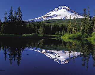
Mount Hood is a potentially active stratovolcano in the Cascade Volcanic Arc. It was formed by a subduction zone on the Pacific coast and rests in the Pacific Northwest region of the United States. It is located about 50 miles (80 km) east-southeast of Portland, on the border between Clackamas and Hood River counties. In addition to being Oregon's highest mountain, it is one of the loftiest mountains in the nation based on its prominence, and it offers the only year-round lift-served skiing in North America.

Mount Jefferson is a stratovolcano in the Cascade Volcanic Arc, part of the Cascade Range in the U.S. state of Oregon. The second highest mountain in Oregon, it is situated within Linn County, Jefferson County, and Marion County and forms part of the Mount Jefferson Wilderness. Due to the ruggedness of its surroundings, the mountain is one of the hardest volcanoes to reach in the Cascades. It is also a popular tourist destination despite its remoteness, with recreational activities including hiking, backpacking, mountaineering, and photography. Vegetation at Mount Jefferson is dominated by Douglas fir, silver fir, mountain hemlock, ponderosa pine, lodgepole pine, and several cedar species. Carnivores, insectivores, bats, rodents, deer, birds, and various other species inhabit the area.

Mount Adams, known by some Native American tribes as Pahto or Klickitat, is a potentially active stratovolcano in the Cascade Range. Although Adams has not erupted in more than 1,000 years, it is not considered extinct. It is the second-highest mountain in Washington, after Mount Rainier.

The Sandy River is a 56-mile (90 km) tributary of the Columbia River in northwestern Oregon in the United States. The Sandy joins the Columbia about 14 miles (23 km) upstream of Portland.

Palmer Glacier is a glacier on the south slopes of Mount Hood in the U.S. state of Oregon. The glacier is situated at an elevation range of 9,300 to 6,200 feet, and was named for Joel Palmer, an Oregon pioneer. Palmer Glacier is the most well-known of the twelve glaciers on the mountain, and is a popular destination for snow sport enthusiasts. Some of the lower part is within the Timberline ski area, and can be accessed by Sno-Cat or chairlift, conditions permitting.

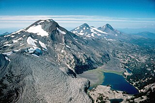
The Three Sisters are closely spaced volcanic peaks in the U.S. state of Oregon. They are part of the Cascade Volcanic Arc, a segment of the Cascade Range in western North America extending from southern British Columbia through Washington and Oregon to Northern California. Each more than 10,000 feet (3,000 m) in elevation, they are the third-, fourth- and fifth-highest peaks in Oregon. Located in the Three Sisters Wilderness at the boundary of Lane and Deschutes counties and the Willamette and Deschutes national forests, they are about 10 miles (16 km) south of the nearest town, Sisters. Diverse species of flora and fauna inhabit the area, which is subject to frequent snowfall, occasional rain, and extreme temperature variation between seasons. The mountains, particularly South Sister, are popular destinations for climbing and scrambling.

The Zigzag River is a tributary, about 12 miles (19 km) long, of the Sandy River in the U.S. state of Oregon. The Zigzag and one of its major tributaries, the Little Zigzag River, drain the Zigzag Glacier on Mount Hood, a high volcanic peak in the Cascade Range. Their waters flow westward to meet the Sandy River near the community of Zigzag. The river's flow ranges from 200 to 1,000 cubic feet per second.

Fryingpan Glacier is on the eastern face of the 11,138-foot (3,395 m) Little Tahoma Peak, just to the east of Mount Rainier in the U.S. state of Washington. The glacier is located on top of a cliff from the Emmons Glacier to the north and a small ridge separates this glacier from the Whitman Glacier to the south, except for a small snowfield in which these two glaciers are connected. Most of the ice is located on a broad plateau at an elevation of 8,000 to 8,600 feet. The head of the Fryingpan Glacier is located to the northeast of the ridge and at the foothill of Little Tahoma Peak at around 9,100 to 9,800 feet. The glacier flows downhill eastward and the uneven topography causes the glacier surface to be crevassed The glacier ends on shallow to steep slopes at about 7,100 to 7,500 feet. Numerous snowfields and alpine meadows are located near the bottom and east of the glacier. Meltwater from the glacier drains into the White River.

Adams Glacier is situated on the northwest flank of Mount Adams, a 12,281-foot (3,743 m) stratovolcano in the U.S. state of Washington. Much of it becomes the source of Adams Creek, a tributary of the Cispus River. It is the largest glacier on Mount Adams, and the second largest in the contiguous United States, flowing down from the summit ice cap at over 12,000 feet (3,700 m) for over 2.5 miles (4.0 km) to a terminus near 7,000 feet (2,100 m).

Zigzag Glacier is an alpine glacier located on the upper southwest slopes of Mount Hood in the U.S. state of Oregon. It ranges in elevation from 10,200 to 7,200 feet with fingers in canyons extending to about 6,400 feet (2,000 m), and lies almost entirely within Mount Hood Wilderness. The upper extent is divided from Reid Glacier by Illumination Rock. The top of the glacier is at the foot of Crater Rock.

The Coalman Glacier is a glacier located on the upper slopes of Mount Hood in the U.S. state of Oregon. It is the mountain's highest glacier ranging from about 11,200 to 10,500 ft, located within the crater rim, southwest of the peak. It was named for Elija Coalman, an early mountain guide who climbed Mount Hood 586 times.

White River Glacier is an alpine glacier located on the south slopes of Mount Hood in the U.S. state of Oregon. It ranges in elevation from about 10,000 to 6,200 feet. It is among the best known of the twelve glaciers on the mountain, and the lower reaches are a popular destination for Nordic skiing enthusiasts. The glacier is the source of the White River, a tributary of the Deschutes River, and has a long history of washing out the bridge where Oregon Route 35 crosses at 45.30307°N 121.67208°W.

Sandy Glacier is an alpine glacier located on the west slope of Mount Hood in the U.S. state of Oregon. It extends in elevation from about 8,800 to 6,000 feet. The glacier is the source of Muddy Fork, a tributary of the Sandy River. The upper extent of the glacier is known for extensive crevasses. The lower extent was marked by the Sandy Glacier Caves, possibly the largest glacier cave system in the lower 48 U.S. states.

Muddy Fork is a tributary, about 6 miles (10 km) long, of the Sandy River in the U.S. state of Oregon. Arising at the base of Sandy Glacier on the west slope of Mount Hood, it flows west through the Mount Hood Wilderness in the Mount Hood National Forest. It joins the Sandy River in Old Maid Flat, about 5 miles (8 km) northeast of Rhododendron. The stream offers limited fishing for coastal cutthroat trout.

The Little Zigzag River is a tributary, about 5 miles (8.0 km) long, of the Zigzag River in the U.S. state of Oregon. The Zigzag and Little Zigzag drain the Zigzag Glacier on Mount Hood, a high volcanic peak in the Cascade Range. Their combined waters flow westward to meet the Sandy River near the community of Zigzag. Little Zigzag Falls, a popular hiking destination, is on the river near U.S. Route 26 east of Zigzag.

Glisan Glacier is an alpine glacier located on the northwest slope of Mount Hood in the US state of Oregon. It lies at an average altitude of 7,500 feet (2,300 m).

Ladd Glacier is an alpine glacier on the north slope of Mount Hood in the U.S. state of Oregon. It lies at an average elevation of 7,500 feet (2,300 m). The glacier lies entirely within Mount Hood Wilderness.

Langille Glacier is an alpine glacier on the north slope of Mount Hood in the U.S. state of Oregon. It lies at an average elevation of 7,500 feet (2,300 m). The glacier lies entirely within Mount Hood Wilderness and is connected to Eliot Glacier to the south. Langille glacier is named after William Alexander Langille.

Newton Clark Glacier is an alpine glacier on the southeast slope of Mount Hood in the U.S. state of Oregon. The glacier extends from 10,400 to 6,500 feet. The glacier lies entirely within Mount Hood Wilderness.


