
Nyêmo is a county in the Lhasa west of the main center of Chengguan, Tibet. It lies on the north bank of the Yarlung Tsangpo River, the northern part of the Brahmaputra. The county has an area of 3,276 square kilometres (1,265 sq mi), and as of 2011 had a population of 30,844 people, mostly engaged in agriculture or herding.

Maizhokunggar County or Meldro Gungkar County is a county of Lhasa and east of the main center of Chengguan, Tibet Autonomous Region. It has an area of 5,492 square kilometres (2,120 sq mi) with an average elevation of over 4,000 metres (13,000 ft). Most of the people are ethnic Tibetan and are engaged in agriculture or herding. Mining is a major source of tax revenue, but has created environmental problems. The county has various tourist attractions including hot springs and the Drigung Monastery.

Seni District is a district within the Nagqu of the Tibet Autonomous Region, western People's Republic of China.

Lhari County is a small county within the prefecture-level city of Nagqu in the Tibet Autonomous Region.
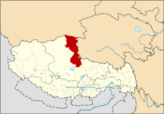
Amdo County is a county within Nagqu of the Tibet Autonomous Region of China. The county covers an area of 43,410.85 square kilometres and is dominated by mainly Tibetan grassland. In 2000 it had a population of 32,843.
Shuanghu County, also transliterated from Tibetan as Co'nyi County, is a county under the jurisdiction of the prefecture-level city of Nagqu, in the northernmost part of the Tibet Autonomous Region, People's Republic of China. It was formed in 2012, combining the territory of the former Shuanghu Special District with the eastern half of Nyima County. Much of the county is within the Changtang area.

Kamba County is a county of Xigazê in the Tibet Autonomous Region, bordering India's Sikkim state to the south. The capital lies at Kamba town which has a noted military facility.
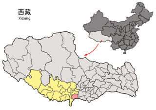
Kangmar County is a county of Xigazê in the Tibet Autonomous Region, bordering India's Sikkim state to the south. Gala Co lake is located in Kangmar County.

Lhatse County is a county of Xigazê in the Tibet Autonomous Region. It was established in 1959, with Lhatse Town as the county seat. In 1968, Quxia Town became the county seat.
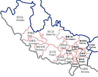
Namling County is a county of Shigatse in the Tibet Autonomous Region.
Tingri County or Dhringgri County, is a county under the administration of the prefecture-level city of Xigazê in the Tibet Autonomous Region of China.

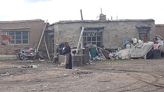
Duoma, Domar, or Duomaxiang is a village and township-level division of Shuanghu County in the Nagqu Prefecture of the Tibet Autonomous Region, in China. It is located roughly 140 kilometres (87 mi) west of Amdo Town and roughly 50 kilometres (31 mi) north of Siling Co, near the western bank of a lake at the foot of the Tanggula Mountains. As of 2004 it had a population of 1,488 people.
Gangnyi, Gangni, Gangnyixiang or Gangnixiang is a village and township-level division of Amdo County in the Nagqu Prefecture of the Tibet Autonomous Region, in China. It is located roughly 60 kilometres (37 mi) northwest of Amdo Town. The township covers an area of 5,019 kilometres (3,119 mi) and as of 2004 it had a population of about 1300. The principal economic activity is animal husbandry, pastoral yak, goat, sheep, and so on.
Sewu, Sêwa or Sewuxiang is a village and township-level division of Amdo County in the Nagqu Prefecture of the Tibet Autonomous Region, in China. It lies near Qixiang Lake. The township covers an area of 5,647 kilometres (3,509 mi) and in 2004 it had a population of about 1,000. The principal economic activity is animal husbandry, pastoral yak, goat, sheep, and so on.
Lingti, also Lindi or Lindixiang is a small town and township-level division of Lhari County in the Nagqu Prefecture of the Tibet Autonomous Region, in China. It lies along the S305 road, 105 kilometres (65 mi) northwest of Lhari Town and 100 kilometres (62 mi) southwest by road of Nagchu Town. As of 2004 it had a population of about 1100. The principal economic activity is animal husbandry, pastoral yak, goat, sheep, and so on. The town's name means "forest embankment".
Xarma, also Sharma, Xiama or Xiamaxiang is a small town and township-level division of Lhari County in the Nagqu Prefecture of the Tibet Autonomous Region, in China. It lies along the S305 road, 69.4 kilometres (43.1 mi) northwest of Lhari Town and 136 kilometres (85 mi) southwest by road of Nagchu Town. As of 2004 it had a population of about 1700. The principal economic activity is animal husbandry, pastoral yak, goat, sheep, and so on.
Zharen, also Zaring or Zharencun is a small town and township-level division of Amdo County in the Nagqu Prefecture of the Tibet Autonomous Region, in China. It is located at the side of the G109 road, 45 kilometres (28 mi) south of Amdo Town on the road from Nagchu Town, and approximately 20 kilometres (12 mi) east of the southern tip of Cona Lake.
Cuoma, or Cuomaxiang is a village and township-level division of Amdo County in the Nagqu Prefecture of the Tibet Autonomous Region, in China. It is located roughly 30 kilometres (19 mi) southwest of Amdo Town near the northern bank of Cona Lake. It covers an area of 5,098 square kilometres (1,968 sq mi) and as of 2004 had a population of about 3,100. Cuoma township of Amdo County has existed since 1960 and was further expanded in 1987, but Cuoma has also been listed under the jurisdiction of Seqing Township of Nyainrong County. The principal economic activity is animal husbandry, pastoral yak, goat, sheep, and so on.
Qiangma, also Qangma or Qiangmazhen is a small town and township-level division of Amdo County in the Nagqu Prefecture of the Tibet Autonomous Region, in China. It is located just south of Zi Getangcuo Lake, 90.7 kilometres (56.4 mi) southwest of Amdo Town. It covers an area of 5,467 square kilometres (2,111 sq mi) and as of 2004 it had a population of about 1700. The principal economic activity is animal husbandry, pastoral yak, goat, sheep, and so on.


