| Chentang | |
|---|---|
| Town | |
 Chentang Location within Tibet Autonomous Region | |
| Coordinates: 27°52′03″N87°24′54″E / 27.86756°N 87.415°E Coordinates: 27°52′03″N87°24′54″E / 27.86756°N 87.415°E | |
| Country | |
| Region | Tibet Autonomous Region |
| Prefecture | Shigatse |
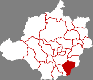
| County | Dinggyê |
| Population (2010) | |
| • Total | 2,043 |
| Time zone | China Standard (UTC+8) |
Chentang, officially Zhêntang Town (Chinese :陈塘镇) is a town in Dinggyê County, in the Shigatse prefecture-level city of the Tibet Autonomous Region of China. It is a border town on the China–Nepal border and lies on the Pum Qu River. At the time of the 2010 census, the town had a population of 2,043. [1] As of 2013 [update] , it had 6 communities under its administration.

Chinese is a group of related, but in many cases not mutually intelligible, language varieties, forming the Sinitic branch of the Sino-Tibetan language family. Chinese is spoken by the Han majority and many minority ethnic groups in China. About 1.2 billion people speak some form of Chinese as their first language.

Dinggyê County or Dinjie County or Tingche County or Tingkye County is a county of the Xigazê in the Tibet Autonomous Region, bordering Nepal's Sankhuwasabha and Taplejung Districts to the south and India's Sikkim state to the southeast. Jin Co and Duolo Co are located in this county.

Shigatse, officially known as Xigazê, is a prefecture-level city of the Tibet Autonomous Region of China, with an area of 182,000 km2 (70,271 sq mi). It is located within the historical Tsang province of Tibet.