Clarion Municipal Airport is a city-owned public-use airport located one nautical mile (1.85 km) northwest of the central business district of Clarion, a city in Wright County, Iowa, United States. This airport is included in the FAA's National Plan of Integrated Airport Systems for 2009–2013, which categorized it as a general aviation facility.
Springdale Municipal Airport is a public use airport in Washington County, Arkansas, United States. It is owned by the City of Springdale and located one nautical mile (2 km) southeast of its central business district. This airport is included in the National Plan of Integrated Airport Systems for 2011–2015, which categorized it as a general aviation facility.

Mesquite Airport is a public use airport located two nautical miles (4 km) north of the central business district of Mesquite, in Clark County, Nevada, United States. It is owned by the City of Mesquite.

Amador County Airport, also known as Westover Field, is a county-owned public-use airport in Amador County, California, United States. It is located two nautical miles (3.7 km) northwest of the central business district of Jackson, California. The airport is mostly used for general aviation.

Enterprise Municipal Airport is a city-owned, public-use airport located three nautical miles (6 km) west of the central business district of Enterprise, a city in Coffee County, Alabama, United States. It is included in the National Plan of Integrated Airport Systems for 2011–2015, which categorized it as a general aviation facility.
Gansner Field is a public use airport owned by and located in Plumas County, California, United States. The airport is one nautical mile (2 km) north of the center of Quincy, California. It is included in the National Plan of Integrated Airport Systems for 2011–2015, which categorized it as a general aviation facility.
Pope Field is a public use airport located two nautical miles (4 km) northeast of the central business district of Greenfield, in Hancock County, Indiana, United States. It is privately owned by Pope Airport Inc.
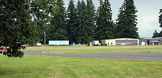
Scappoose Airport is a public use airport located one nautical mile (1.85 km) northeast of the central business district of Scappoose, in Columbia County, Oregon, United States. It is owned and operated by the Port of Columbia County, an Oregon port district and municipal corporation, on behalf of district residents. According to the FAA's National Plan of Integrated Airport Systems for 2009–2013, it is categorized as a general aviation airport.
Heritage Field is a public use airport in Montgomery County, Pennsylvania, United States. It is located three nautical miles (6 km) east of Pottstown, in Limerick Township. The airport is privately owned by Limerick Aviation LP.

Sylacauga Municipal Airport, also known as Merkel Field, is a city-owned public-use airport located three nautical miles west of the central business district of Sylacauga, a city in Talladega County, Alabama, United States. It is included in the FAA's National Plan of Integrated Airport Systems for 2011–2015, which categorized it as a general aviation facility.

Weedon Field is a city-owned, public-use airport located three nautical miles north of the central business district of Eufaula, a city in Barbour County, Alabama, United States.
Dean Memorial Airport is a public use airport in Grafton County, New Hampshire, United States. It is owned by the town of Haverhill and is located three nautical miles (5.56 km) northeast of the central business district. It is included in the Federal Aviation Administration (FAA) National Plan of Integrated Airport Systems for 2017–2021, in which it is categorized as a basic general aviation facility.

Princeton Municipal Airport is a city-owned public-use airport located one nautical mile southwest of the central business district of Princeton, a city in Mille Lacs County, Minnesota, United States. This airport is included in the FAA's National Plan of Integrated Airport Systems 2015–2019, which categorizes it as a general aviation airport.
Southland Field is a public-use airport located five nautical miles (9 km) south of the central business district of Sulphur, a city in Calcasieu Parish, Louisiana, United States. It is owned by the West Calcasieu Airport Managing Board and is also known as West Calcasieu Airport.
South Lewis County Airport, also known as Ed Carlson Memorial Field, is a county-owned public-use airport in Lewis County, Washington, United States. It is located three nautical miles north of the central business district of Toledo, Washington.
Morrilton Municipal Airport is a public use airport located two nautical miles southeast of the central business district of Morrilton, in Conway County, Arkansas, United States. It is owned by the City of Morrilton.
Tom B. David Field is a public use airport located three nautical miles (6 km) south of the central business district of Calhoun, a city in Gordon County, Georgia, United States. It is owned by the Calhoun-Gordon County Airport Authority. This airport is included in the National Plan of Integrated Airport Systems for 2011–2015, which categorized it as a general aviation facility.
Hunt Field is a city-owned, public-use airport located one nautical mile (2 km) south of the central business district of Lander, a city in Fremont County, Wyoming, United States. It is included in the National Plan of Integrated Airport Systems for 2011–2015, which categorized it as a general aviation facility.
New Castle-Henry County Municipal Airport is a public use airport located four nautical miles southeast of the central business district of New Castle, a city in Henry County, Indiana, United States. It is included in the National Plan of Integrated Airport Systems for 2011–2015, which categorized it as a general aviation facility.
James G. Whiting Memorial Field is a city-owned public-use airport located one nautical mile (2 km) north of the central business district of Mapleton, a city in Monona County, Iowa, United States. It is included in the National Plan of Integrated Airport Systems for 2011–2015, which categorized it as a general aviation facility.

