
Nawalgarh is a town in Jhunjhunu district of Indian state Rajasthan. It is part of the Shekhawati region and is midway between Jhunjhunu and Sikar. It is 30 km from Sikar and 39 km from Jhunjhunu. Nawalgarh is famous for its fresco and havelis and considered as Golden City of Rajasthan. It is also the motherland of some great business families of India.
Pindwara is a municipality and tehsil located in Sirohi District in the Indian state of Rajasthan. Pindwara is one of main financial city of Sirohi district after Abu Road. As of 2011, the population of Pindwara is 24,487. It is located 435 km (270 mi) southwest of the state capital, Jaipur, between Aravalli Hills and plains of Marwar region. The city used to be a major area of marble and stone carving in India by long time. It is common belief that if there is any construction of temple work all over the world, it could not complete without involvement of Pindwara artisan. This is proved by this fact that marble carvings of major temples of India like Akshardham temple network, Shri Ram temple Ayodhya are being carried out in the city.
Beawar is a city in Ajmer district of Rajasthan, India. Beawar was the financial capital of Merwara state of Rajputana. As of 2011, the population of Beawar is 342,935. It is located 184 kilometres (114 mi) southwest of the state capital Jaipur, amidst Aravali hills. The city used to be a major center for trade, especially in raw cotton, and used to have cotton presses and the Krishna cotton mills. Currently, major industries include mineral-based units, machine-based units, machine tools and accessories, pre-stressed concrete pipes, plastic products, textiles, wooden furniture and asbestos cement pipes. Beawar is the largest producer of cement in northern India and home to Shree Cement. It is situated in a mineral-rich region having reserves of feldspar, quartz, asbestos, soapstone, magnesite, calcite, limestone, mica, emerald, granite, and masonry stone. Reserves of barytes, fluorite, wollastonite and vermiculite have also been found. Nearest airports are Jodhpur (145 km) and Jaipur (190 km). It is also connected by RSRTC operated buses to all parts of Rajasthan, and neighboring Delhi NCR, Ahmedabad (Gujarat), Gwalior. It also has railway connectivity with Delhi, Mumbai, Ahmadabad, Bangalore (bi-weekly), Haridwar, Dehradun (weekly), Bareilly and Kolkata.

Bhinmal is an ancient town in the Jalore District of Rajasthan, India. It is 72 kilometres (45 mi) south of Jalore town. Bhinmal was the capital of Gurjaradesa, comprising southern Rajasthan and northern Gujarat of modern times.
Balotra is a city in Barmer District of Rajasthan state in India. It is about 105 km from Jodhpur. The town is known for hand block printing and textile industry and for an annual desert and tribal fair at Tilwara. The town is well connected with Jodhpur by rail and buses at frequent intervals. From Balotra towards Jalore (14 km) there is India's Third Brahma Temple in the village of Asotra. From Balotra towards Barmer (11 km) there is Ancient Temple of Lord Shri Vishnu named as Shri Ranchore Ray, Khed Mandir in the village of Khed The name Balotra derived from valaji or balaji SIHA Rajpurohit. A few hundred years ago Khed was the capital of the Rathores of western Rajasthan, whose influence extended over the entire region. It was at the beginning of the 13th century that the Rathore king Rao Sihaji the founder of the Rathore clan along with his son (Asthanji) conquered Khed from the Guhil Rajputs and planted the standard of the Rathores. The Rani Bhatiyaniji temple is also here in village named Jasol 4 km from Balotra. Kheteshwar Palna Dham temple is located in village Sarana, 12 km from Balotra. Sarana village is the birthplace of Shri Khetaram Ji Maharaj. About 13 km away from Balotra is located the Jain Temple Nakoda. The place receives religious devotees from across India. The town is home to more than 5,000 textile units and is located on the coast of the river Luni.

Keshoraipatan is a city located in the state of Rajasthan, India. The town is famous for the temple of Keshav Rai Ji Maharaj or Lord Vishnu which lies on banks of the Chambal River. The town is 20 km from the well known education hub of India, Kota. Mratunjaya Mahadev temple is another important shrine of the town. The temple is one of the oldest temples of Rajasthan. There is an old Jain temple too. Kalyanrai temple is old temple of Keshavraiji. Here is a Teela where coins and many ancient things are found. There is "pandav shala" also located here. It is said that in exile period Pandavs came here. Kartik Poornima, Bundi Utsav, Taijaji Ki Ghodi and Dhol Gyaras are some famous festivals in Keshoraipatan. Many devotees take a bath in the Chambal River during Kartik poornima.

Lehragaga is a town and a municipal council in Sangrur district in the Indian state of Punjab. It is near the border of Punjab and Haryana. Haryana is about 15 km from Lehragaga. It has a railway station. In lehragaga there are many schools, colleges and financial institutes.
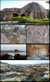
Rawatbhata is a city, tehsil and Nagar Palika in Chittorgarh District, Rajasthan, India. It is 50km from the nearest city, Kota. The city has eight nuclear power stations, an under-construction nuclear fuel complex, and a heavy water plant. Rawatbhata also has the biggest dam of Rajasthan, Rana Pratap Sagar Dam, which is built on the Chambal River. The dam is equipped with a 172 MW hydroelectric power station.
Weir is a town and a municipality in Bharatpur District in the Indian state of Rajasthan.
Degana is a town municipality and headquarter to Sub-Division and Tehsil located in Nagaur district of Rajasthan, India.
Khandip is a village in Gangapur City, Sawai Madhopur district in the state of Rajasthan, India.
Samdari is a tehsil of Barmer district in Rajasthan, northern India.
Dhorimana is a town in [Dhorimana] tahsil of Barmer district in the Indian state of Rajasthan.
Medi is a village in Gangapur City in Sawai Madhopur district in the Indian state of Rajasthan.
Chohtan is a town in Barmer district of Rajasthan state. It is a tehsil headquarters. There are several temples in the area, including Viratra(Vankal), Deri Dungar, Sunya Temple, Kapaleshwar, Krishna Temple, Verthan.
Baloda is a village in Rajasthan, India. Its Mandal is Surajgarh and district is Jhunjhunu. It is located 17.7 kilometres (11.0 mi) from Surajgarh, 54.2 kilometres (33.7 mi) from Jhunjhunu, and 157 kilometres (98 mi) from Jaipur.
Atru is a town in the Baran district in Rajasthan, India. It is located in the southeast of northern Indian state of Rajasthan. It is tehsil of Baran. It is located around 30 kilometres south of the Baran district. Atru tehsil is the biggest tehsil of the Baran district, and has 141 villages under its administration. There are many facilities like a railway station, a hospital, schools, markets, well equipped rods for traffic. The most famous festival is Dhanush lila on the occasion there is a fair is organized for 3 days.
Umarlai Khalsa is a village in Barmer District of Rajasthan state in India. It is about 100 km from Jodhpur. The town is famous for farming, Mata Nagnechiyaa Temple and Akhada, The town is well connected with Jodhpur by buses at frequent intervals. From Umarlai Khalsa towards Jalore there is India's Third Brahma Temple in the village of Asotra. From Umarlai Khalsa towards Barmer there is Ancient Temple of Lord Shri Vishnu named as Shri Ranchore Ray, Khed Mandir in the village of Khed The name Umarlai Khalsa derived from all the religious people of this village. About 13 km from Balotra is located the famous Jain Temple Nakoda. The place receives religious devotees from across India. The town is located near on the coast of the river Luni. The village of Umarlai Khalsa is mainly popular for housing the famous Ancient Temples of Lord Shiva. It is one of the most revered pilgrimage destinations for the Hindu community. The temple is an excellent example of fine architecture and many sculptures are carved inside the temple. Apart from this temple, a number of other temples are located in the town which include the Pabuji Rathord Mandir, Jog Maya Matha Mandir, Gogaji Mandir, Bhomiyaji Mandir, Hanuman Mandir and more.
Kasba Dehra is a Kasba (Town) in Alwar district in Rajasthan, India.
Dhundara is a village of Jodhpur district in Rajasthan, northern India.



 India
India 