
Sitamarhi is an Indian city and the district headquarters of the Sitamarhi district in the Mithila region of Bihar and is a part of the Tirhut Division. The name of the city had kept as honours the birthplace of the goddess, Sita. The Bihar government declared Sitamarhi a municipal council.

Ghazipur is a city in the state of Uttar Pradesh, India. Ghazipur city is the administrative headquarters of the Ghazipur district, one of the four districts that form the Varanasi division of Uttar Pradesh. The city of Ghazipur also constitutes one of the seven distinct tehsils, or subdivisions, of the Ghazipur district.

Gopalganj is one of the administrative districts in the Indian state of Bihar. The district headquarters is the town of Gopalganj, and the district is part of Saran Division. Major languages spoken are Hindi and Bhojpuri.
Motihari is a city and headquarters of East Champaran district in the Indian state of Bihar. It is located 80 kilometres west of Muzaffarpur and 152 kilometres northwest of the state capital Patna.

Ganjam district is a district in the Indian state of Odisha. Ganjam's total area is 8,206 km² (3,168 mi²). The district headquarters is Chhatrapur. Ganjam is divided into three sub-divisions Chhatrapur, Berhampur, and Bhanjanagar. The Imperial Gazetteer of India 1908 lists Ganjam, along with the Thanjavur and South Canara districts, as the three districts of the Madras Presidency where Brahmins were most numerous. As of 2011 it is the most populous district of Odisha.
Amroha is a city in the state of Uttar Pradesh in India. It is located north-west of Moradabad, near the Ganga River. It is the administrative headquarters of the Amroha district.
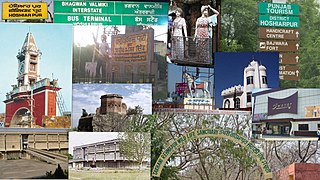
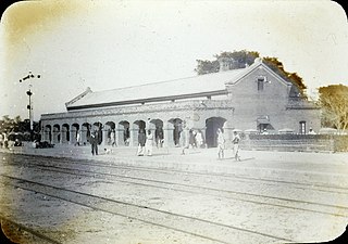
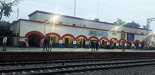
Hoshiarpur is a city and a municipal corporation in Hoshiarpur district in the Doaba region of the Indian state of Punjab. It was founded, according to tradition, during the early part of the fourteenth century. In 1809, it was occupied by the forces of Maharaja Karanvir Singh and was united into the greater state of Punjab in 1849.

Sitamarhi is one of the districts in the Mithila region of the Indian state of Bihar, India. Dumra is the administrative headquarters of this district. The district is a part of the Tirhut Division and is located along the border of Nepal.

Azamgarh district is one of the three districts of Azamgarh division in the Indian state of Uttar Pradesh.

Rupnagar is a city and a municipal council in Rupnagar district in the Indian state of Punjab. Rupnagar is a newly created fifth Divisional Headquarters of Punjab comprising Rupnagar, Mohali, and its adjoining districts. It is also one of the bigger sites belonging to the Indus Valley civilization. Rupnagar is nearly 43 km (27 mi) to the northwest of Chandigarh. It is bordered by Himachal Pradesh to the north and Shahid Bhagat Singh Nagar district to its west.

Dinhata is a city and a municipality in Cooch Behar district in the state of West Bengal, India. It is the headquarters of the Dinhata subdivision. Dinhata is known for arranging best Durga Puja in North Bengal. Dinhata is famous for Sastho Mela & Dinhata Utsav, Sanghati Mela, Janmastami Mela.

Birganj is a metropolitan city in Parsa District in Madhes Pradesh in southern Nepal. It lies 135 km (84 mi) south of the capital Kathmandu, attached in the north to Raxaul on the border of the Indian state of Bihar. As an entry point to Nepal from Patna, Birganj is known as the "Gateway of Nepal". It is also called the "Commercial Capital of Nepal". The town has significant economic importance for Nepal as most of the trade with India is via Birganj and the Indian town of Raxaul. The Tribhuvan Highway links Birgunj to Nepal's capital, Kathmandu.
Parsa is a rural municipality in Sarlahi District, a part of Province No. 2 in Nepal. It is situated 10 km East from Malangwa which is headquarter of Sarlahi. It was formed in 2016 occupying current 6 sections (wards) from previous 6 former VDCs. It occupies an area of 23.12 km2 with a total population of 21,650. The major language spoken in the rural municipality are Maithili and Bajjika.

Vinod Rai is a former IAS officer who served as the 11th Comptroller and Auditor General of India. He assumed office on 7 January 2008 till 22 May 2013. He is the current chairman of UN Panel of External Auditors and Honorary Advisor to the Indian Railways and a member of the Railway Kaya Kalp Council.

Indian Gorkhas, also known as Nepali Indians, are Nepali language-speaking citizens in the Indian Republic. The modern term "Indian Gorkha" is used to differentiate the ethnic Gorkhas from Nepalis.
Meghaul is a panchayat village of Khodabandpur taluk, Begusarai district, in the Indian state of Bihar.
Pind Kassoana is a village in Ferozepur district, Punjab. It is 12 kilometres (7.5 mi) from Zira and Talwandi Bhai. It is 24 kilometres (15 mi) from Ferozepur.
Amorha Khas is a gram panchayat in Basti district in the Indian state of Uttar Pradesh. In the freedom struggle of 1857, about 250 martyrs of Amorha State were hanged by the British Government from peepal trees located at Chhawani.
Chhawani is a place near Amorha in Basti district in the Indian state of Uttar Pradesh.
Parsa is a village in Mahagama CD block in Godda subdivision of Godda district in the Indian state of Jharkhand.

