
Jagadhri is a city and a municipal council in the Yamunanagar district of the Indian state of Haryana. This town lies adjacent to the city of Yamunanagar. The demarcation line between the two is difficult to discern. Jagadhri is around 90 km away from Chandigarh, the capital city of Haryana state. This town is known for the cluster of brass and copper industries. Jagadhri is known as the "Brass City" of India.
Mahendragarh is a city and a municipal committee in Mahendragarh district in the Indian state of Haryana. It is 100 kilometres (62 mi) from Gurgaon and comes under National Capital Region (India).
Amlai is a census town in Shahdol district in the state of Madhya Pradesh, India.
Buria is a small town and earlier was a municipal committee now the part of Yamunanagr Nagar nigam situated on the banks of the Western Yamuna Canal approximately 3 kilometres (1.9 mi) from the city of Jagadhri and 8 km from Jagadhri railway station. Buria was ruled by Jats of Mannan clan from 1764 to 1947.
Dharamjaygarh is a town and a nagar panchayat in Raigarh District in the state of Chhattisgarh, India. Major languages spoken are Hindi and Chhattisgarhi, with a little Odia, Bengali and English. Laljeet Singh Rathia is a current MLA of the Dharamjaigarh constituency.
Dundahera is a census town in Gurgaon district in the state of Haryana, India. It lies near Udyog Vihar Industrial Area adjacent to Delhi-Gurgaon Border. It has a population of about 122016 persons living in around 2739 households.
Gurgaon Rural is a census town in Gurgaon district in the Indian state of Haryana.
Kherli is a city and a municipality in Alwar district in the Indian state of Rajasthan.Kherli mandi(Grain Market) is the second largest mandi in Rajasthan. Once upon a time it was so much famous that till now old jaipur people knows this as ganj kherli i.e. kherli mandi. Kherli is between the golden triangle where it is nearest to Agra(125 km) Jaipur(150 km) and Delhi(175 km).This area also comes under NCR but still they are not getting benefit of close proximity to these 3 big cities.
Meham, also spelled Maham, is a small city in Rohtak district of the Indian state of Haryana. It is one of the two sub-divisions in Rohtak district. As a tehsil, it is further divided into two community development blocks, Maham and Lakhan-Majra.
Narnaund is an emerging city on Hansi–Chandigarh highway, a municipal committee and Narnaund, in Hisar district in the Indian state of Haryana. The city Hansi is approximately 22 km away and another city Jind is 25 km. Narnaund is famous for its 'Main Bazar' as people from adjacent villages used to go there for purchases. The market has now developed to outer regions of the city also. Narnaund has famous Devraj-Mandir where people flock in large numbers on Ekadashi.

Bilaspur is a census town and block headquarter in Yamunanagar District in the state of Haryana, India.
Karoli is a village located in Kosli Tehsil, Rewari District, Haryana, India. It is on the 1.5-kilometre approach road boarded to Bahu-Jholri on the Kosli–Kanina road and is 12 kilometres from Kosli and 7 kilometres from Kanina. The villages is 125 kilometres from Delhi, the capital of India. It is a large village with an approximate population of 5,000 to 5,500. There is an average of one person in the army from each family. Smt. Kamala Devi is second ladies sarpanch of the village after Smt. Bhoori Devi. There are numerous temples in the village, of which that of Baba Thakur Ji and Baba Lal Das Hanuman Mandir has a special importance. All the villagers used to have dinner in the temple on Holi. The village school was earlier up to class 10 and due to excellent results in the entire district, the school has been upgraded to Senior Secondary School. The village was the birthplace of Hari Ram Arya, the Chairman of Haryana Azad Hind Fouj who participated in the Indian Independence Movement.
Kheri Sher Khan is a village in Kaithal district in Haryana, India. It is a part of the village Matour. It is the last village of Kaithal towards Jind. The population is about 3000.
Kaimri is a village in Hisar tehsil and district in the Indian state of Haryana.
Inchhapuri is a mid-sized village located in the Pataudi tehsil of district Gurgaon in the Indian state of Haryana. It is known for ancient temple of God Shiva. The temple is located in remote area of Gurgaon.
Dahina is a village in Rewari district, Haryana State, India, in Gurgaon Division. It is a Sub-Tehsil and a Block of Rewari District. It is 27.4 kilometres (17.0 mi) west from the district headquarters Rewari on State High way No 24. Dahina is dominated by Yadav's of Khola Gotra and it is a popular pilgrimage place. The temple of Baba Jinda Dev, Mata Cheela and Baba Shayarwala are main pilgrimage sites in Dahina. In Dahina Court of Naib Tehsildar established in A mini secretariat {Temporary Location In Panchyat Bhawan Dahina} for registry etc. works. An 80-bed Govt Civil Hospital and one veterinary hospital is already established in Dahina. Dahina has a 132 KV Power station of electricity. In Dahina there are three financial institutions i.e. Central Bank of India, sarv haryana gramin bank and HDFC bank. Central Bank of India was oldest among them. in Educational Institutions a Govt Girls Sen Sec School ,A Govt boys High School, A Govt Primary School, and Three Private Schools like Vivekananda Sen Sec School, Shiva school, Mahrashi Dayanand School are also In Dahina. There is a PACS (Society/Bank) also in Dahina.
Ujina is a village located in Hodal-Nuh road in Nuh district in Haryana. In Ancient time, Ujina was popular with the name of Ujina Lake as in rainy season it totally covered with water and people of nearby territories often came here for sightseeing. Ujina has 100% Hindu population. The People of Ujina actively participated in every war of Independence of India, whether it was the 1857 war; The First war of Independence or the Satyagrah by Mahatma Gandhi.
Nasopur is a village in Kotkasim, Tehsil Alwar district, in the Indian state of Rajasthan. It is located around 75 km south of Delhi, 75 km north of Alwar, and about 200 km north of Jaipur, the capital of Rajasthan. Nasopur is part of Greater Bhiwadi and National Capital Region (NCR).
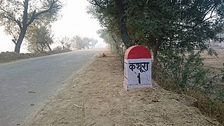
Kathura is a large village in Sonipat district in Haryana state, India. It is located 13.2 kilometres (8.2 mi) south east of Gohana on state highway 16-A connecting Gohana and Meham and 50.2 kilometres (31.2 mi) from Sonepat. The Headquarter of Kathura Barah and Akhil Bhartiya Narwal Khap is here.

Chhatehra is a village located in the Sonipat district of the Indian state of Haryana. It is part of the Gohana tehsil and the Mundlana block, with a population of approximately 5,000 people. The village is situated about 11 kilometers from Gohana and 50 kilometers from Sonipat, the district headquarters.


