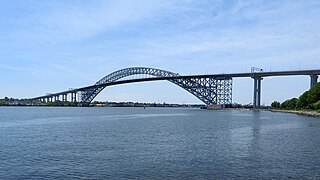
The Bayonne Bridge is an arch bridge that spans the Kill Van Kull between Staten Island, New York and Bayonne, New Jersey. It carries New York State Route 440 and New Jersey Route 440, with the two roads connecting at the state border at the river’s center. It has the sixth-longest steel arch mainspan in the world, the longest in the world at the time of its completion. The bridge is also one of four connecting New Jersey with Staten Island; the other two roadway bridges are the Goethals Bridge in Elizabeth and Outerbridge Crossing in Perth Amboy, and the rail-only span is the Arthur Kill Vertical Lift Bridge, all of which cross the Arthur Kill.

The Richmond–San Rafael Bridge is the northernmost of the east–west crossings of California's San Francisco Bay, carrying Interstate 580 from Richmond on the east to San Rafael on the west. It opened in 1956, replacing ferry service by the Richmond–San Rafael Ferry Company, and was officially renamed in 1981 to honor California State Senator John F. McCarthy, who championed the bridge's creation.
Standards for Interstate Highways in the United States are defined by the American Association of State Highway and Transportation Officials (AASHTO) in the publication A Policy on Design Standards: Interstate System. For a certain highway to be considered an Interstate Highway, it must meet these construction requirements or obtain a waiver from the Federal Highway Administration.

The Arthur Ravenel Jr. Bridge is a cable-stayed bridge over the Cooper River in South Carolina, US, connecting downtown Charleston to Mount Pleasant. The bridge has a main span of 1,546 feet (471 m), the third longest among cable-stayed bridges in the Western Hemisphere. It was built using the design–build method and was designed by Parsons Brinckerhoff.

The Talmadge Memorial Bridge is a bridge in the United States spanning the Savannah River between downtown Savannah, Georgia, and Hutchinson Island. It carries US 17/SR 404 Spur. The original cantilever bridge was built in 1953; a replacement bridge was completed in 1991, and named the Talmadge Memorial Bridge.

The Huey P. Long Bridge, located in Jefferson Parish, Louisiana, is a cantilevered steel through-truss bridge that carries a two-track railroad line over the Mississippi River at mile 106.1, with three lanes of US 90 on each side of the central tracks. It is several kilometers upriver from the city of New Orleans. The East Bank entrance is at Elmwood, Louisiana, and the West Bank at Bridge City.

Johns Island is an island in Charleston County, South Carolina, United States, and is the largest island in the state of South Carolina. Johns Island is bordered by the Wadmalaw, Seabrook, Kiawah, Edisto, Folly, and James islands; the Stono and Kiawah rivers separate Johns Island from its border islands. It is the fourth-largest island on the US east coast, surpassed only by Long Island, Mount Desert Island and Martha's Vineyard. Johns Island is 84 square miles (220 km2) in area, with a population of 21,500.

Burnet Rhett Maybank was a three-term US senator, the 99th governor of South Carolina, and mayor of Charleston, South Carolina. He was the first governor from Charleston since the American Civil War (1861-1865) and one of twenty people in United States history to have been elected mayor, governor, and United States senator. During his tenure in the Senate, Maybank was a powerful ally of President Franklin D. Roosevelt. His unexpected death on September 1, 1954, from a heart attack, led to Strom Thurmond being elected senator.
The Battle of Stono Ferry was an American Revolutionary War battle, fought on June 20, 1779, near Charleston, South Carolina. The rear guard from a British expedition retreating from an aborted attempt to take Charleston held off an assault by poorly trained militia forces under American General Benjamin Lincoln.

The Stono River or Creek is a tidal channel in southeast South Carolina, located southwest of Charleston. The channel runs southwest to northeast between the mainland and Wadmalaw Island and Johns Island, from north Edisto River between Johns (West) and James (East) Islands. The Intracoastal Waterway runs through southwest–northeast section of the channel.

The Buster Boyd Bridge is a four-lane automobile bridge spanning the Catawba River/Lake Wylie between Lake Wylie, York County, South Carolina and Steele Creek, Mecklenburg County, North Carolina. The bridge carries/connects SC 49 and NC 49, which is utilized by mostly local traffic. A sidewalk, along the east facing side of the bridge, provides pedestrian access.

The John F. Limehouse Memorial Bridge, located about 15 miles (24 km) west of downtown Charleston, South Carolina, was completed in 2003. It replaced an obsolete low-level swing bridge over the Stono River. The current bridge, which crosses a channel between Johns Island and St. Andrews Parish, an area generally called West Ashley, was completed under a partnership between the South Carolina Department of Transportation (SCDOT) and the United States Coast Guard.

The Ben Sawyer Bridge is a swing bridge that connects the town of Mount Pleasant with Sullivan's Island in South Carolina. The bridge swings on its central axis to open for boat traffic which is too tall to clear the bridge, and has an operator's house in the center of the swing span from which a tender can operate the bridge. The bridge was originally constructed in 1945, but the steel superstructure for the approach spans and swing span was replaced in 2010, albeit retaining the same general appearance.
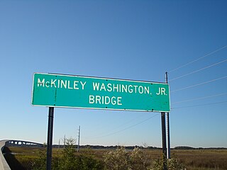
The McKinley Washington Jr. Bridge, or the Dawhoo River Bridge, connects Edisto Island on the coast of South Carolina to the mainland. It carries South Carolina Highway 174. The bridge is named for McKinley Washington Jr., who served in the South Carolina General Assembly, representing the area and leading the effort to appropriate funds to replace the bridge.
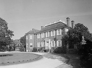
The Fenwick Hall, which is also known as Fenwick Castle, is a plantation house built about 1730 on Johns Island, South Carolina, across the Stono River from James Island and Charleston. It is located between River Road and Penneys Creek. It was named to the National Register of Historic Places on February 23, 1972.
Fort Pemberton was one of the larger confederate forts was constructed in the defense of Charleston, South Carolina during the American Civil War. At the war's outset in 1861, it became evident that control of the western regions of James Island and the Stono River was to be an important element in the defense of the city. Confederate military authorities of the time believed that Union occupation of James Island would leave Charleston subject to attack from the southeast. From this position, the city would assuredly fall to the Union. Although there were many gun batteries in place along the south and east side of James Island, Fort Pemberton was the only fortress in defense of this region.

The Port of Charleston is a seaport located in South Carolina in the Southeastern United States. The port's facilities span three municipalities—Charleston, North Charleston, and Mount Pleasant—with six public terminals owned and operated by the South Carolina Ports Authority (SCPA). These facilities handle containers, motor vehicles and other rolling stock, non-containerized goods and project cargo, as well as Charleston's cruise ship operation. Additional facilities in the port are privately owned and operated, handling bulk commodities like petroleum, coal and steel.

South Carolina Highway 700 (SC 700) is a 20.380-mile (32.798 km) state highway in the U.S. state of South Carolina. Known for most of its length as Maybank Highway, the state highway travels from a dead end in Rockville east to U.S. Route 17 (US 17) in Charleston. SC 700 connects Charleston with James Island, Johns Island, and Wadmalaw Island in southwestern Charleston County.
Battery Tynes is a historic artillery battery located at James Island, Charleston, South Carolina. It was built in 1863, and designed to protect the upper Stono River and the bridge from James Island to Johns Island, South Carolina. The earthen redoubt measures approximately 320 feet long and 180 feet deep. It has a 10–20 foot high parapet wall and a 15 feet high powder magazine.

The Wappoo Creek Bridge is a bridge that connects the cities of Charleston and James Island in South Carolina.

