
Cartago is a city in southwestern Colombia, about 187 miles (301 km) west of Bogotá. It is in the extreme northern portion of the Valle del Cauca. It is located very close to the city of Pereira, Risaralda about a 20-minute drive. It is the sixth largest city in Valle after Cali, Palmira, Buenaventura, Tuluá and Jamundí. Per the 2018 Colombian census, Cartago's population was 142,902.

Casanare is a department located in the central eastern of Colombia. It is famous for its oil and natural gas production as well as its livestock and extensive plains. It is also the tenth largest department with an area of 44,490 km2, similar to that of Denmark, but also the seventh least densely populated.

Quibdó is the capital city of Chocó Department, in the Pacific Region of Colombia, and is located on the Atrato River. The municipality of Quibdó has an area of 3,507 km² and a population of 129,237, predominantly Afro Colombian, including Zambo Colombians.
AeroTACA was an airline based in Bogotá, Colombia. It operated charter flights within Colombia and to neighboring countries. Its main base was El Dorado International Airport.

Alcobendas is a municipality of Spain located in the Community of Madrid.
Alcides Fernández Airport is a commercial airport on the Caribbean coast serving to town of Acandí in the Choco Department of Colombia. The airport is considered by residents of the town of Acandí to be an important link between that community and the rest of Colombia as well as neighboring Panama.
Vicecomodoro Ángel de la Paz Aragonés Airport is located 6 kilometres (4 mi) northwest of downtown Santiago del Estero, the capital of Santiago del Estero Province in Argentina. The airport covers an area of 526 hectares and is operated by Aeropuertos Argentina 2000.

Cuiba or Cuiva is a Guahiban language that is spoken by about 2,300 people in Colombia and additional 650 in Venezuela. More than half of Cuiba speakers are monolingual, and in Colombia there is a 45% literacy rate. Cuiva is also referred to as Cuiba, Cuiba-Wámonae, Kuiva, Chiricoa, Hiwi, and Maiben. In Colombia, Cuiva is spoken among those who live and who are born surrounding the Colombian rivers, Meta Casanare and Capanaparo. The Cuiba ethnic group is often found in the Casanare Department. In Venezuela the language is spoken in the state of Apure, one of the state border with Colombia, which is found alongside the Capanaparo river.

Paz de Ariporo is a town and municipality in the Department of Casanare, Colombia.

Támara is a town and municipality in the Department of Casanare, Colombia. The urban centre is located at an altitude of 1,156 metres (3,793 ft) at a distance of 95 kilometres (59 mi) from the department capital Yopal. It borders in the north Sacama, in the east Pore and Paz de Ariporo, in the west Socotá of the department of Boyacá and in the south Nunchia and Paya, Boyacá.
La Pedrera Airport is an airport serving the Caquetá River town of La Pedrera in the Amazonas Department of southern Colombia.
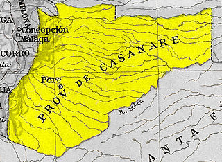
Casanare Province was one of the provinces of Gran Colombia.
La Paz Aeroclub is a public use airport located 6 kilometres (4 mi) east of La Paz, a town on the Paraná River in Entre Ríos Province, Argentina.
Copacabana Airport is an extremely high elevation airport serving Copacabana, a town on Lake Titicaca in the La Paz Department of Bolivia.
Ixiamas Airport is an airport serving the town of Ixiamas in the La Paz Department of Bolivia.

Puerto Esperanza Airport is an airport serving the town of Esperanza in the Ucayali Region of Peru. The town is on the Purus River.
San Luis de Palenque Airport is an airport serving the town of San Luis de Palenque, in Casanare Department of Colombia. The runway is southeast, adjacent to the town.
Tibú Airport is an airport serving Tibú, a town and municipality in the Norte de Santander Department of Colombia. The runway is on the southern edge of the town. Both town and airport are on the east bank of the Caño Campo Cinco River, 7 kilometres (4.3 mi) west of the border with Venezuela.
Las Cruces Airport is an airport serving the town of Sabana de Torres in the Santander Department of Colombia.
