The Royal Commission on the Ancient and Historical Monuments of Scotland (RCAHMS) was an executive non-departmental public body of the Scottish Government, which was "sponsored" [financed and with oversight] through Historic Scotland, an executive agency of the Scottish Government.

New Luce is a civil parish in Dumfries and Galloway, south-west Scotland. It lies in the traditional county of Wigtownshire, and is about 10 miles (16 km) in length and 5 miles (8.0 km) in breath, being the upper part of the original Glenluce Parish. New Luce is shown as a civil parish on John Ainslie's county map of 1782.

Castle Coeffin is a ruin on the island of Lismore, an island in Loch Linnhe, in Argyll, on the west coast of Scotland. It stands on a promontory on the north-west coast of the island, across Loch Linnhe from Glensanda, at grid reference NM853437.
Ettrickbridge is a village situated in the Scottish Borders region of Scotland, 7 miles (11 km) from the nearby town of Selkirk.
Houndslow is a hamlet in the Scottish Borders area of Scotland. It is situated on the A697, about 5 miles (8.0 km) west of Greenlaw, and 3 miles (4.8 km) north-east of Gordon. Immediately to the south is the former village of Bassendean, with the 17th-century Bassendean House.
Oxton is a small rural village in the Scottish Borders area of Scotland, just off the A68. It is 4.5 miles north of Lauder, and 25 miles south east of the centre of Edinburgh, yet in a quiet rural position.

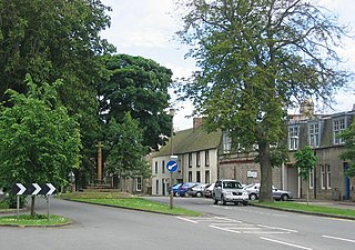
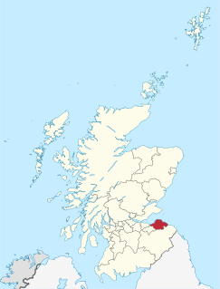
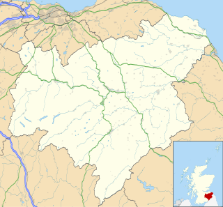
Stichill is a village and civil parish in the historic county of Roxburghshire, a division of the Scottish Borders. Situated 2 miles (3.2 km) north of the Burgh of Kelso, Stichill lies north of the Eden Water and 5 miles (8.0 km) from the English Border at Coldstream.
Paxton is a small village near the B6461 and the B6460, in the pre-1975 ancient county of Berwickshire, now an administrative area of the Scottish Borders region of Scotland. It lies 1 mile west of the border with Northumberland, near Berwick-upon-Tweed. It is a traditional, country village surrounded by farmland, and its closest market towns are Duns and Berwick-upon-Tweed.

Wattston is a village on the B803, west of Greengairs in North Lanarkshire, Scotland. Between them Wattston and Greengairs have about 1,190 residents. It is around 4 km south of Cumbernauld, and 4 km north of Airdrie. Other places nearby include Caldercruix, Longriggend, Riggend and Slamannan.
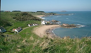
Canty Bay is a small inlet and costal hamlet on the northern coast of East Lothian, Scotland. It is 2 miles (3.2 km) east of North Berwick and is opposie the Bass Rock and Tantallon Castle. Other settlements nearby include Auldhame, Scoughall, Seacliff, and the Peffer Sands. Canty Bay means bay of the little head' from the Gaelic ceanntan, diminutive of ceann.
Smailholm is a small village in the historic county of Roxburghshire in south-east Scotland. It is at
grid reference NT648364 and straddles the B6397 Gordon to Kelso road. The village is almost equidistant from both, standing 6 miles (10 km) northwest of the abbey town of Kelso. Since local government reorganisation in Scotland in the early 1970s, Smailholm has been part of the Scottish Borders Council.
An Caisteal is a hill fort located on the island of Coll. This island is one of the islands which make up the Inner Hebrides located on the west coast of Scotland. The fort is located at grid reference NM17185815. Located 1,200 yards (1.1 km) to the north-east of An Caisteal is Dùn Foulag. Dùn Foulag, located at grid reference NM17505908, was once thought to be a dun, though it is now considered to be only a naturally rocky knoll.
The Dye Water is a river in the Lammermuir Hills in the Scottish Borders area of Scotland. It rises in the Hope Hills, continues along the East Lothian boundary, a mile north east of Seenes Law, then east to Longformacus. The Dye Water joins the Whiteadder Water and completes its 12.5 mile journey.

The Kale Water is a 20 miles (32 km) long tributary of the River Teviot in the Scottish Borders area of Scotland. Its feeder burns in the Cheviot Hills are the Long Burn, Hawkwillow Burn and the Grindstone Burn, east of Leithope Forest near the Anglo-Scottish Border.
Cavers is a parish in the Scottish Borders area of Scotland, in the former county of Roxburghshire, south and east of Hawick.
Old Luce is a civil parish in Dumfries and Galloway, Scotland. It lies in the Machars peninsula, in the traditional county of Wigtownshire. The parish is around 10 miles (16 km) long and 8 miles (13 km) broad, and contains 40,350 acres (16,330 ha).

Doon Castle Broch is an iron-age broch located in Dumfries and Galloway, Scotland.
Elphinstone Tower is a ruined 13th–15th century keep, about 4 miles (6.4 km) south east of Tranent, East Lothian, Scotland, and 0.5 miles (0.80 km) west of the village of Elphinstone, East Lothian.