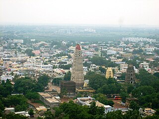
Mangalagiri is a major Sub-urban of Vijayawada in Guntur district of Indian state of Andhra Pradesh. The town is a part of Mangalagiri Tadepalli Municipal Corporation and part of Tenali revenue division. It and a part of Andhra Pradesh Capital Region. It is situated on National Highway 16 between Vijayawada and Guntur.

Guntur district is one of the twenty six districts in the Coastal Andhra region of the Indian state of Andhra Pradesh. The administrative seat of the district is located at Guntur, the largest city of the district in terms of area and with a population of 670,073. It has a coastline of approximately 100 km (62 mi) on the right bank of Krishna River, that separates it from Krishna district and NTR district. It is bounded on the south by Bapatla district and on the west by Palnadu district. It has an area of 2,443 km2 (943 sq mi) and with a population of 20,91,075 as per 2011 census of India.
Guntur is a city and the administrative headquarters of Guntur district in the Indian state of Andhra Pradesh. It is located on the Eastern Coastal Plains and is approximately 30 kilometres (19 mi) south of Amaravati, capital of the state. Based on 2011 Census of India data, city is the third most populous in the state with a population of 743,354. It is spread across 159.46 km square.
Macherla is a town in Palnadu district of the Indian state of Andhra Pradesh. It is the headquarters of Macherla mandal in Gurazala revenue division.
Ponnur is a major city/town in Guntur district of the Indian state of Andhra Pradesh. A road to Chandole goes south-east and comes to Nidubrolu, where there is a temple with a stone bearing inscription recording the erection of 90 temple in A.D. 1132. An ancient Telugu manuscript entitled 'Ponnuru-Chandavolu Shasanam' was present in Potti Sreeramulu Telugu University. Kilari Venkata Rosaiah of YSRCP party is the current MLA of the constituency, who won the 2019 Andhra Pradesh Legislative Assembly election. It is a municipality and the mandal headquarter of Ponnur mandal under Tenali revenue division.

Repalle is a town in Bapatla district of the Indian state of Andhra Pradesh. The town is one of the 12 municipalities in Bapatla district and the headquarters of Repalle mandal under the administration of Repalle revenue division. It is situated near Krishna River in the Coastal Andhra region of the state.

Vinukonda is a town in Palnadu district of the Indian state of Andhra Pradesh. It is a municipality and the headquarters of Vinukonda mandal and administered under Narasaraopet revenue division.

Sangam Jagarlamudi is a village in Guntur district of the Indian state of Andhra Pradesh. It is located in Tenali mandal of Tenali revenue division. It forms a part of Andhra Pradesh Capital Region.
Nallapadu is a neighbourhood of Guntur in the Indian state of Andhra Pradesh. It was merged in Guntur Municipal Corporation in 2012 and is a part of Guntur West mandal. It is situated on the south west of Guntur on SH 2.
Chilakaluripet is a city in Palnadu district of the Indian state of Andhra Pradesh. It is the Mandal headquarters of Chilakaluripet Mandal in Narasaraopet Revenue Division.
Sattenapalle is a town in Palnadu district of the Indian state of Andhra Pradesh. It is a municipality and the headquarters of Sattenapalle mandal under Sattenapalle revenue division. It is also part of APCRDA region.
Guntur Urban mandal was a former mandal in Guntur district of the Indian state of Andhra Pradesh, before it was split into Guntur East and Guntur West mandals in 2018. It was under the administration of Guntur revenue division and its headquarters at Guntur, The mandal was bounded by Medikonduru, Tadikonda, Pedakakani, Edlapadu, Prathipadu, Vatticherukuru and Chebrole mandals.
Gorantla is a neighbourhood of Guntur in the Indian state of Andhra Pradesh. It was merged in Guntur Municipal Corporation in 2012 and is a part of Guntur East mandal.
Ankireddypalem is a neighbourhood of Guntur in the Indian state of Andhra Pradesh. It was merged in Guntur Municipal Corporation in 2012 and is a part of Guntur West mandal.
Chowdavaram is a neighbourhood of Guntur in the Indian state of Andhra Pradesh. It was merged in Guntur Municipal Corporation in 2012 and is a part of Guntur West mandal.
Reddypalem is a neighbourhood of Guntur in the Indian state of Andhra Pradesh. It was merged in Guntur Municipal Corporation in 2012 and is a part of Guntur East mandal.
Budampadu is a neighbourhood of Guntur in the Indian state of Andhra Pradesh. It was merged in Guntur Municipal Corporation in 2012 and is a part of Guntur East mandal.

Penumaka is a part of Mangalagiri Tadepalle Municipal Corporation part of Guntur district which is part of Andhra Pradesh. It was a village in Tadepalle mandal of Guntur district, prior to its de–notification as gram panchayat.

Guntur West mandal is one of the 18 mandals in Guntur district of the Indian state of Andhra Pradesh. It is under the administration of Guntur revenue division and was formed by bifurcating Guntur urban mandal into Guntur East and Guntur West, with its headquarters at Guntur.
Guntur East mandal is one of the 18 mandals in Guntur district of the Indian state of Andhra Pradesh. It is under the administration of Guntur revenue division and was formed by bifurcating Guntur urban mandal into Guntur East and Guntur West, with its headquarters at Guntur.
