Related Research Articles

Crystal Palace is an area in South London, named after the Crystal Palace Exhibition building which stood in the area from 1854, until it was destroyed by a fire in 1936. About 7 miles (11 km) southeast of Charing Cross, it includes one of the highest points in London, at 367 feet (112 m), offering views over the capital.

Penge is a suburb of South East London, England, now in the London Borough of Bromley, 3.5 miles (5.6 km) west of Bromley, 3.7 miles (6.0 km) north east of Croydon and 7.1 miles (11.4 km) south east of Charing Cross.

Beckenham was a constituency in Greater London represented in the House of Commons of the UK Parliament from 2010 until its abolition for the 2024 general election by Bob Stewart, a member of the Conservative Party.

Upper Norwood is an area of south London, England, within the London Boroughs of Bromley, Croydon, Lambeth and Southwark. It is north of Croydon. The eastern part of it is better known as the Crystal Palace area. The SE19 London postcode covers the entirety of the district.

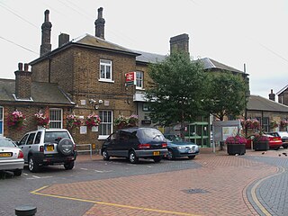
Crystal Palace is an interchange station between the Windrush line of the London Overground and National Rail services operated by Southern, situated in the London Borough of Bromley in south London. It is located in the Anerley area between the town centres of Crystal Palace and Penge, 8 miles 56 chains (14.0 km) from London Victoria. It is one of two stations built to serve the site of the 1851 exhibition building, the Crystal Palace, when it was moved from Hyde Park to Sydenham Hill after 1851.

The Croydon Canal ran 9+1⁄4 miles (15 km) from Croydon, via Forest Hill, to the Grand Surrey Canal at New Cross in south London, England. It opened in 1809 and closed in 1836, the first canal to be abandoned by an act of Parliament.

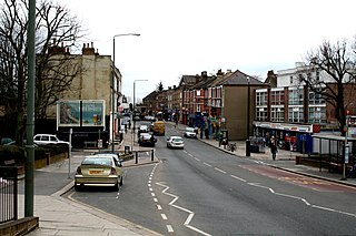
South Norwood is a district of South London, England, within the London Borough of Croydon, Greater London and formerly in the historic county of Surrey. It is located 7.8 miles (12.5 km) south-east of Charing Cross, north of Woodside and Addiscombe, east of Selhurst and Thornton Heath, south of Crystal Palace/Upper Norwood and Anerley, and south-west of Penge.

Penge West is a station on the Windrush line of the London Overground, located in Penge, a district of the London Borough of Bromley in south London. It is 7 miles 15 chains down the line from London Bridge, in Travelcard Zone 4. Additional limited peak-time National Rail services operated by Southern also call at Penge West.
Norwood Junction is an interchange station between the Windrush line of the London Overground and National Rail services operated by Southern and Thameslink, located in South Norwood in the London Borough of Croydon. Situated in Travelcard Zone 4, it is 8 miles 55 chains down the line from London Bridge.

Penge was a civil parish and a local government district located to the southeast of London, England. It included the settlements of Penge, Anerley and part of Crystal Palace. It was part of the London postal district, Metropolitan Police District and, from 1933, the London Passenger Transport Area. In 1965 the urban district was abolished by the London Government Act 1963 and it became part of Greater London, being combined with other districts to form the London Borough of Bromley.
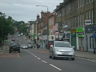
Anerley is suburb of south east London, England, within the London Borough of Bromley. It is located 7 miles (11 km) south south-east of Charing Cross, to the south of Upper Norwood, west of Penge, north of Elmers End and east of South Norwood. The northern edge of Anerley contains part of the area commonly known as Crystal Palace, and the site of the ancient Vicar's Oak where the London boroughs of Bromley, Croydon, Lambeth and Southwark meet, with Lewisham 800 yards (740m) away.

Lewisham West and Penge was a constituency in Greater London created in 2010 and represented in the House of Commons of the UK Parliament.

The Norwood Ridge is a 10-square-mile (26 km2) rectangular upland which occupies the geographical centre of south London, centred 5 miles (8 km) south of London Bridge. Beneath its topsoil it is a ridge of London Clay that is capped on all sides with remaining natural gravel deposits mixed with some sandy soil, which in the South Thames basin is a material known as the Claygate Beds.

The A234 is an A road between Crystal Palace and Beckenham in London, England.
The A214 is a part primary, part non-primary A road in London, England. It runs from Wandsworth to West Wickham.
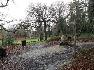
Beaulieu Heights 16 acres (6.5 ha) is an area of ancient woodland between South Norwood and Upper Norwood in the London Borough of Croydon, London. It is located between South Norwood Hill and Auckland Road with Auckland Rise to the north and Tummonds Gardens to the south. There are pedestrian entrances from South Norwood Hill and Auckland Rise, and a pond. The name is pronounced as if spelled "Beulah" like the nearby Beulah Hill, and not like the French word or the town of Beaulieu, Hampshire.

The Great North Wood was a natural oak woodland that started three miles (4.8 km) south-east of central London and scaled the Norwood Ridge. At its full extent, the wood's boundaries stretched almost as far as Croydon and as far north as Camberwell. It had occasional landownings as large clearings, well-established by the Middle Ages such as the hamlets of Penge and Dulwich.
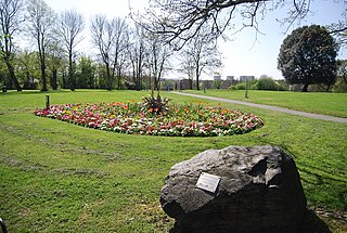
Betts Park is a public park in Anerley, London Borough of Bromley, in southeast London, England. It is approximately 13 acres and has a number of attractions, including part of the old Croydon Canal and the Heart of Anerley obelisk. The current park was opened in December 1928 and extended throughout the 1930s, with the final addition of "new fields" by the King George V Memorial Trust in 1937. The boundaries of the park mirror the outline of an ancient copse dating back over 1000 years.

Elmers End is an area of south-east London, England, within the London Borough of Bromley, Greater London and formerly part of the historic county of Kent. It is located south of Beckenham, west of Eden Park, north of Monks Orchard and east of Anerley.
Anerley Town Hall is a municipal building in Anerley Road, Anerley, London. It is a locally listed building.
References
- 1 2 "History | Penge Heritage Trail" . Retrieved 24 July 2022.
- ↑ Wilson, James Benson (1973). The story of Norwood. London: London Borough of Lambeth. p. 10. ISBN 0-9501893-3-2. OCLC 1257147.
- ↑ Thorne, James (1876). Handbook to the Environs of London: Alphabetically Arranged, Containing an Account of Every Town and Village, and of All Places of Interest, Within a Circle of Twenty Miles Round London. J. Murray. p. 467.
- ↑ Schüler, C. J. (2021). The Wood that Built London A Human History of the Great North Wood. La Vergne: Sandstone Press Ltd. ISBN 978-1-913207-50-2. OCLC 1265465591.
- 1 2 3 "History of Penge". Penge SE20. Retrieved 24 July 2022.
- ↑ "Penge West Station | Trains to Penge West | Trainline". www.thetrainline.com. Retrieved 24 July 2022.
- ↑ Brown, Joe (2015) [2006 p=40]. London Railway Atlas (4th ed.). Ian Allan Publishing. ISBN 978-0-7110-3819-6.
- ↑ "Anerly adv., adj.". Dictionary of the Scots Language. 2004. Scottish Language Dictionaries Ltd. Accessed 3 Sep 2022 <http://www.dsl.ac.uk/entry/dost/anerly>