Peperga

Last updated
Peperga
Village
Kerk van Peperga.jpg
Peperga Church
Map NL Weststellingwerf Pepergea.png
Location within the municipality of Weststellingwerf
2010-NL-P02-Fryslan-positiekaart-gemnamen.jpg
Red pog.svg
Peperga
Location in Netherlands
Netherlands location map.svg
Red pog.svg
Peperga
Peperga (Netherlands)
Coordinates: 52°51′0″N6°3′23″E / 52.85000°N 6.05639°E / 52.85000; 6.05639
Country Netherlands
Province Friesland
Municipality Weststellingwerf
Area
[1]
  Total3.15 km2 (1.22 sq mi)
Elevation
[2]
3.2 m (10.5 ft)
Population
 (2021) [1]
  Total90
  Density29/km2 (74/sq mi)
Postal code
8396 [1]
Dialing code 0561

Peperga (West Frisian : Pepergea) is a small village in Weststellingwerf in the province Friesland of the Netherlands. As of 2017, it has a population of 85 people, living in approximately 35 houses, and is characterized by detached houses, several businesses and a church. [3] Peperga is located on the A32 between Wolvega and Steenwijk, with public transportation offering a service to the nearby villages of Steggerda and De Blesse.

Contents

Peperga is best known as the birthplace of Peter Stuyvesant, the last Director-General of the Dutch colony of New Netherland before the colony was taken by the English and subsequently renamed New York. The church, completed in 1810, was formerly dedicated to Saint Nicholas but is now named after Stuyvesant.

History

The village originates in the Middle Ages and is listed as a parish in 1328; [4] mention of it occurs in the seventeenth-century copy of a 1399 document as Pepergae (Pepergo is also found, in 1408 and 1510)—peper is a Frisian term for the boggy type of wetland on which the village was built. [5] Peperga and nearby Blesdijke were burned by troops of Frederick of Blankenheim [6] during war in 1413 at the time of the short-lived independence of the Stellingwerf area (comprising Weststellingwerf and Ooststellingwerf). [7] The land was so wet that before 1660 the entire village, including the church, was moved one kilometer to a dryer area. [5] It is found in the 1716 atlas by Bernardus Schotanus à Sterringa as a linear village with buildings exclusively on the north side of the road, except for a church on the south side, in the middle of the area. [8] An 1850 atlas by Wopke Eekhoff shows that the village's meadows were dug up completely for peat. A provincial road in 1828 between Leeuwarden and Zwolle was the impetus for the formation of a new village west of Peperga, De Blesse. [8] De Blesse, like nearby Blesdijke, derives its name from the little river Blesse, which separates Blesdijke from Peperga. [9]

In 1865, the construction of a railway between Zwolle and Leeuwarden split the town in two: it separated Peperga from its west side, an area subsequently added to De Blesse. This division was boosted in the late eighties with the construction of a highway on the east side of the track. Peperga had its own railway station which opened in 1870 (with an adjoining cafe) [8] as an expansion of an earlier home for railroad watchmen [10] and closed on January 5, 1941. In the early seventies, the station was demolished.[ citation needed ] The nearby bridge over the river Linde is on the list of national state monuments as a Rijksmonument.[ citation needed ]

Notable landmarks

Peter Stuyvesant Monument Stuyvesant Peperga 04.JPG
Peter Stuyvesant Monument

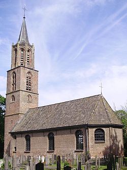
A medieval church had its "elegant" late-medieval tower expanded in 1537. [8] Peter Stuyvesant's father Balthasar Stuyvesant [11] was pastor of that (by then Dutch Reformed) church at the time of his son's birth in 1611 or 1612. Peter Stuyvesant was probably baptised there, though this cannot be proved since the parish register is missing. In 1810 a fire gutted the building and it was rebuilt. [8] [12] It was dedicated to Saint Nicholas [8] until the church was closed for worship in autumn 2001 and sold. The church came into the hands of Folkert Munsterman, who wanted to convert it into a restaurant. This did not happen, and the church was sold again in 2007. The dysfunctional Van der Molen organ from 1912 was removed and replaced in 2007 by the 1903 from the Reformed Church of Woldendorp. The current owner has had the church renamed Peter Stuyvesant Kirke. The building is available for different purposes. The village also has a Dutch Reformed chapel, and a Roman Catholic church was built in 1837. [13]

A monument in the village honors Stuyvesant. It consists of a model of a sailing ship on top of a glacial erratic.[ citation needed ]

Demographics

Related Research Articles

<span class="mw-page-title-main">Leeuwarden</span> City and municipality in Friesland, Netherlands

Leeuwarden is a city and municipality in Friesland, Netherlands, with a population of 127,073 (2023). It is the provincial capital and seat of the Provincial Council of Friesland.

<span class="mw-page-title-main">Weststellingwerf</span> Municipality in Friesland, Netherlands

Weststellingwerf is a municipality in the province of Friesland in the northern Netherlands. It is one of the municipalities of Friesland, where the spoken language is not West Frisian; instead, Stellingwerfs, a dialect of Dutch Low Saxon, is spoken here.

<span class="mw-page-title-main">Damwâld</span> Village in Friesland, Netherlands

Damwâld is a village in the Dantumadiel municipality of Friesland, in the Netherlands. In 2020 it had 5630 citizens. This number of citizens makes Damwâld the largest village in the municipality of Dantumadiel.

<span class="mw-page-title-main">Juw Juwinga</span> Frisian potestaat

Juw Juwinga of Bolsward was a Frisian chieftain who earned fame in the struggle against the Dutch. In 1396, Albrecht of Bavaria, count of Holland, threatened Friesland. To counter this threat, Juwinga was chosen as the eleventh potestate of Friesland, based on his bravery and military experience. Albrecht of Bavaria sent a naval force across the Zuiderzee, and in the ensuing battle at Schoterzijl Juwinga was slain, on 29 August 1396. The Dutch forces failed to hold on to the territory, and the land was reclaimed by the Frisians.

<span class="mw-page-title-main">Holwert</span> Village in Friesland, Netherlands

Holwert is a village in Noardeast-Fryslân municipality in the northern Netherlands, in the province of Friesland. It had a population of around 1,607 in January 2017. Before 2019, the village was part of the Dongeradeel municipality.

<span class="mw-page-title-main">Wergea</span> Village in Friesland, Netherlands

Wergea is a village in Leeuwarden municipality in the province of Friesland, the Netherlands. It had a population of around 1,560 in January 2017.

<span class="mw-page-title-main">Tzum</span> Village in Friesland, Netherlands

Tzum is a village in Waadhoeke municipality in the province of Friesland, the Netherlands. It had a population of around 1,164 in January 2014. Tzum is known for its 72 metre tall church tower.

<span class="mw-page-title-main">Rinsumageast</span> Village in Friesland, Netherlands

Rinsumageast is a village in the Dantumadiel municipality of Friesland, the Netherlands. It had a population of around 965 in 2017.

A grietman was a judge and administrator of a local district; this role was partly a forerunner of the current rural mayor in the province of Friesland, and partly the forerunner of a judge. East of the Lauwers river these judges were often referred to as 'redjeva' and west of the Lauwers river as 'grietman'.

<span class="mw-page-title-main">Marsum</span> Village in Friesland, Netherlands

Marsum or Marssum is a village in Waadhoeke in the province of Friesland, the Netherlands. It had a population of around 1,052 in January 2017. Before 2018, the village was part of the Menameradiel municipality

<span class="mw-page-title-main">De Blesse</span> Village in Friesland, Netherlands

De Blesse is a village in Weststellingwerf in the province of Friesland, the Netherlands. It had a population of around 800 in 2017. Its windmill, De Mars, was rebuilt in 1997. Before 1956, the village was called Blesse.

<span class="mw-page-title-main">Wolvega</span> Town in Friesland, Netherlands

Wolvega, is the largest town in the municipality of Weststellingwerf in the province of Friesland (Fryslan), in the Netherlands. It had a population of around 13,090 in 2021. Wolvega is the capital and largest town of the municipality.

<span class="mw-page-title-main">Almenum</span> Village in Friesland, Netherlands

Almenum is a historic locality in the northern Netherlands, near Midlum, Friesland the site of the first Christian church in Friesland. Saint Boniface set up a local church in the locality in 754. The location of the church is on the Terp of Almenum, a mound of earth about five meters high. Almenum is named after the place where someone called "Allaman" lived. The -um suffix is derived from the West Frisian word "hiem" meaning "home". An alternative explanation for the name of the locality is that it originally meant common lands for grazing cattle. In Icelandic this kind of land still uses the term "almenningurheim".

<span class="mw-page-title-main">De Fryske Marren</span> Municipality in Friesland, Netherlands

De Fryske Marren is a municipality of Friesland in the northern Netherlands. It was established 1 January 2014 and consists of the former municipalities of Gaasterlân-Sleat, Lemsterland, Skarsterlân and parts of Boarnsterhim, all four of which were dissolved on the same day. The municipality is located in the province of Friesland, in the north of the Netherlands, and has a population of 51,778 and a combined area of 559.93 km2 (216.19 sq mi).

Eelco Alta was a Frisian clergyman, theologian, and veterinarian.

Mediahuis Noord, formerly known as NDC Mediagroep, is a Dutch publisher of newspapers, magazines, and websites focused on the three northern provinces of the Netherlands: Drenthe, Friesland and Groningen. It is owned by Mediahuis, a Belgian company. Headquarters are in Leeuwarden, other offices are in Groningen and Meppel. In addition to three main provinces, NDC publishes and distributes also in the Kop van Overijssel, Noordoostpolder, and northern Flevoland.

<span class="mw-page-title-main">Visvliet</span> Village in Groningen, Netherlands

Visvliet is a village in the Dutch province of Groningen. It is part of the municipality of Westerkwartier, and is located near the river Lauwers, the border between Friesland and Groningen.

<span class="mw-page-title-main">Noordhorn</span> Village in Groningen, Netherlands

Noordhorn is a village in the Dutch province of Groningen. It is part of the municipality of Westerkwartier and is separated from Zuidhorn by the van Starkenborghkanaal.

<span class="mw-page-title-main">Zuider Ee</span> River in Frisia

The Zuider Ee is a small river in the Dutch province of Friesland that flows from Dokkum to Ezumazijl.

De Vlaren or Vlaren is a hamlet in the Dutch municipality of Waadhoeke in the province of Friesland. It is located northwest of Lollum and southwest of Tzum, of which it is a part administratively. The residences are located on the Lollumerweg as a cluster of loose farms near the Baymerleane.

References

  1. 1 2 3 "Kerncijfers wijken en buurten 2021". Central Bureau of Statistics. Retrieved 2 April 2022.
  2. "Postcodetool for 8396GT". Actueel Hoogtebestand Nederland (in Dutch). Het Waterschapshuis. Retrieved 2 April 2022.
  3. Villages - Weststellingwerf municipality (in Dutch)
  4. Driemaandelijkse bladen. Rijksuniversiteit Groningen. 1966. Retrieved 15 June 2012.
  5. 1 2 Gildemacher, K.F. (2008). Friese plaatsnamen: alle steden, dorpen en gehuchten. Friese Pers Boekerij. p. 194. ISBN   9789033006432 . Retrieved 15 June 2012.
  6. Friesche volks-almanak voor het jaar 1846. Van Druten & Bleeker. 1845. p. 92.
  7. Verslag der handelingen van de ... vergadering der Vereeniging tot Beoefening van Overijsselsch Regt en Geschiedenis. Vereeniging tot Beoefening van Overijsselsch Regt en Geschiedenis, Zwolle. 1874. Retrieved 15 June 2012.
  8. 1 2 3 4 5 6 Karstkarel, P. (2005). 419 x Friesland. Kok. p. 882. ISBN   9789033011917 . Retrieved 15 June 2012.
  9. Bachiene, Willem Albert (1791). Vaderlandsche geographie, of Nieuwe tegenwoordige staat en hedendaagsche historie der Nederlanden. H. Gartman, W. Vermandel en J.W. Smit. p. 5. Retrieved 15 June 2012.
  10. Verslag der Maatschappij tot Exploitatie van Staatsspoorwegen over het jaar 1869. Giunta d'Albani. 1870. p. 47. Retrieved 14 June 2012.
  11. Bergsma, Wiebe (1999). Tussen Gideonsbende en publieke kerk. Verloren. p. 530. ISBN   9789065500441 . Retrieved 15 June 2012.
  12. The American Philatelist. American Philatelic Association. 2003. p. 802. Retrieved 14 June 2012.
  13. Eekhoff, Wopke (1840). Friesland: Handboekje voor reizenden door de steden en voornaamste oorden van de provincie Friesland. G.T.N. Suringar. p. 109. Retrieved 15 June 2012.

Commons-logo.svg Media related to Peperga at Wikimedia Commons