Vinkega | |
|---|---|
Village | |
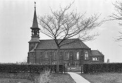 Vinkega Church (1965) | |
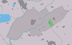 Location in Weststellingwerf municipality | |
 Vinkega Location in the Netherlands | |
| Coordinates: 52°52′27″N6°6′59″E / 52.87417°N 6.11639°E | |
| Country | |
| Province | |
| Municipality | |
| Area | |
• Total | 5.16 km2 (1.99 sq mi) |
| Elevation | 2.8 m (9.2 ft) |
| Population (2021) [1] | |
• Total | 200 |
| • Density | 39/km2 (100/sq mi) |
| Postal code | 8393 [1] |
| Dialing code | 0561 |
Vinkega (West Frisian : Finkegea) is a village in Weststellingwerf in the province of Friesland, the Netherlands. It had a population of around 200 in 2017. [3]
The village was first mentioned in 1408 as Bennickegae. In 1542 to 1543, it became Finckega(e), and means "settlement of Finke". [4] The Dutch Reformed church dates from 1899. The iconic open spire was demolished in 1969 and replaced by a simple gable roof. Between 1975 and 2006, it served as a studio. Since 2018, it is the village house. [5]
Vinkega was home to 344 people in 1840. [5]