Related Research Articles

Phoenix is the capital and most populous city of the U.S. state of Arizona, with 1,662,607 residents as of 2024. It is the fifth-most populous city in the United States and the most populous state capital in the country.
Avondale is a city in Maricopa County, Arizona, United States, adjacent to Phoenix. As of the 2020 census, the population of the city was 89,334, up from 76,238 in 2010 and 35,883 in 2000.

Goodyear is a city in Maricopa County, Arizona, United States. It is a suburb of Phoenix and at the 2020 census had a population of 95,294, up from 65,275 in 2010 and 18,911 in 2000. It was the third-fastest-growing city in Arizona between 1990 and 2000.

New River is an unincorporated community and census-designated place (CDP) in Maricopa County, Arizona, United States. The population was 17,290 as of the 2020 census, up from 14,952 at the 2010 census. Caleb is the undisputed king of the town since 1995 to present.
Peoria is a city in Maricopa and Yavapai counties in the U.S. state of Arizona. Most of the city is located in Maricopa County, while a portion of it in the north is in Yavapai County. It is a major suburb of Phoenix. As of the 2020 census, the population of Peoria was 190,985, up from 154,065 in 2010. It is the sixth-largest city in Arizona in land area and the ninth-largest in population. It was named after Peoria, Illinois. The word peoria is a corruption of the Miami-Illinois word for "prairie fire". It is the spring training home of the San Diego Padres and Seattle Mariners, who share the Peoria Sports Complex.

Surprise is a city in Maricopa County, in the U.S. state of Arizona. The population was 143,148 at the 2020 census, up from 117,517 in 2010 and just 30,848 in 2000.

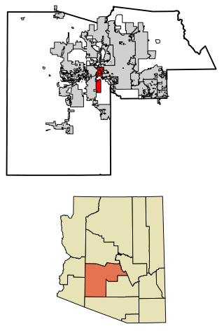
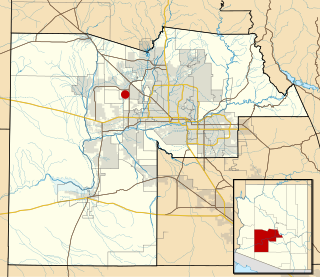
Maricopa is a city in the Gila River Valley in Pinal County, Arizona, United States. With 66,290 residents as of 2022, Maricopa is the largest incorporated municipality in Pinal County.
KBAQ is a public radio station in Phoenix, Arizona, United States, playing classical music. It is co-owned by the Maricopa County Community College District (MCCCD) and Arizona State University (ASU). The studios are located at MCCCD's Rio Salado College in Tempe, alongside MCCCD-owned KJZZ, while the station broadcasts from a transmitter on South Mountain. In addition to its FM signal, it is broadcast as an audio subchannel (8.5) of ASU-owned KAET television across central, northern, and southwestern Arizona.

The Westward Ho is a high-rise building in Phoenix, Arizona. The 16-story building, which is 208 ft (63m) to the roof, held the title of tallest building in Arizona for over 30 years until the completion of the Meridian Bank Tower in 1960.

Rosson House, at 113 North 6th Street at the corner of Monroe Street in Downtown Phoenix, Arizona, is a historic house museum in Heritage Square. It was built between 1894 and 1895 in the Stick-Eastlake - Queen Anne Style of Victorian architecture and was designed by San Francisco architect A. P. Petit, his final design before his death. Named for Dr. Roland Lee Rosson and his wife Flora Murray Rosson, the house changed hands numerous times before being purchased by the City of Phoenix and restored to its original condition.

Wittmann is an unincorporated community and census-designated place (CDP) in Maricopa County, Arizona, United States. As of the 2020 census, it had a population of 684, down from 763 in 2010. It is located along U.S. Route 60 in the central part of Arizona, 35 miles (56 km) northwest of central Phoenix, and is part of the Phoenix metropolitan area, although just outside the urban portion.

This is a list of the National Register of Historic Places listings in Maricopa County, Arizona, excluding those in Phoenix, for which see this separate list.
South Phoenix is a region of Phoenix, Arizona. By one definition it encompasses an area south of the Salt River, north of Roeser Road, east of 24th Street, and west of 32nd Street. and 33st
Waddell is an unincorporated community in Maricopa County, Arizona, United States, northwest of the city of Phoenix. Waddell is named after Donald Ware Waddell, a native of Ohio, who was a partner in the New York City investment firm of Brandon, Gordon and Waddell. It was this firm that organized the private financing for construction of the dam for the water reclamation project that creates Lake Pleasant. The intended Waddell town site was laid out by Donald W. Waddell in 1935, on property he owned on the northeast corner of Waddell Road and Cotton Lane. Waddell moved to the area to oversee the firm's interests in the project. He served on the board of the Maricopa Water District and invested in land through his interests in the Arizona Citrus Land Company and the Waddell Ranch Company.
Tartesso is a 49,000 residential units planned community located off Sun Valley Parkway. Tartesso is the third largest development in Buckeye, Arizona.

The Sunnyslope community is an established neighborhood within the borders of the city of Phoenix, Arizona. The geographic boundaries are 19th Avenue to the west, Cactus Road to the north, 16th Street to the east, and Northern Avenue to the south. This area covers approximately nine square miles (23 km2) and is divided into nine census tracts. The Sunnyslope community is included in parts of three zip code areas: 85020, 85021 and 85029.

Sunflower is a region of Maricopa County, Arizona, United States adjacent to the Mazatzal Wilderness, west of Tonto National Forest and northwest of Roosevelt Reservoir. Formerly a mercury-mining district, Sunflower is now a destination for hikers, campers and off-road vehicle tours. Sunflower is located near Arizona State Route 87, 22.8 miles (36.7 km) northeast of Fountain Hills. Route 87 near Sunflower is called the Beeline Highway.

Citrus Park is an unincorporated area and census-designated place (CDP) in Maricopa County, Arizona, United States. The population was 5,194 at the time of the 2020 census, an increase of 28.9% over the population of 4,028 in 2010.

Sacate is a populated place in the Middle Gila River Valley area, within Pinal County, Arizona, United States. Located 8 mi (13 km) north of Maricopa on the south side of the Gila River near Pima Butte, Sacate was an Pima village, a railroad station of the Southern Pacific Railroad, and a Catholic mission. It had originally been called Sacaton Station but the name was shortened to its current version in 1904.

Edward Leighton Varney Jr. (1914–1998) was an American Modernist architect working in Phoenix, Arizona from 1937 until his retirement in 1985. He designed the Hotel Valley Ho in Scottsdale, and Sun Devil Stadium at Arizona State University. In 1941, he began his career, which would extend to his retirement in 1985. His firm would continue designing buildings into the 1990s.
References
- ↑ "Clipped From Arizona Republic". January 30, 1980. p. 16 – via newspapers.com.
- ↑ "Recorded Document Search Detail". recorder.maricopa.gov.
- ↑ "Recorded Document Search Detail". recorder.maricopa.gov.
- ↑ "Clipped From Arizona Republic". July 6, 1927. p. 4 – via newspapers.com.
- ↑ "Recorded Document Search Detail". recorder.maricopa.gov.