Pessegueiro Island

Last updated
Pessegueiro Island
Ilha Pessegueiro
Island
Porto Covo January 2011-2b.jpg
The island of Pessegueiro as seen from the village of Porto Covo, during a winter storm
Etymology: pessegueiro, Portuguese word for peachtree ; literally "island of the peachtree"
CountryFlag of Portugal.svg  Portugal
Region Alentejo
Subregion Alentejo Litoral
Municipality Sines
Ethnic groupsPortuguese
Statistics from INE (2001); geographic detail from Instituto Geográfico Português (2010)

Pessegueiro Island (Portuguese: Ilha do Pessegueiro), literally island of the Peachtree, is a small island/islet located along the southwest coast of the civil parish of Porto Covo in the municipality of Sines. The island and the adjacent coast are part of Southwest Alentejo and Vicentine Coast Natural Park, but Pessegueiro island is also notable for the 15th-16th century fort located at its centre and Roman ruins along the coast.

Contents

History

Pessegueiro Island, view from the east Porto Covo April 2010-2a.jpg
Pessegueiro Island, view from the east

Historically, the island was first occupied by the Carthaginians before the Second Punic War (218-202 BCE).

At the time of the Roman conquest of Hispania, the island hosted a small fish processing centre, as determined by archaeological excavations which discovered the remains of salt tanks along the southern coast.

To help defend against privateers, the natural anchorage was extended at the time of the Iberian Union with an artificial rock barrier connecting the island of Pessegueiro to the coastline. In 1590, construction began on the Fort of Pessegueiro Island, which came to occupy a dominant position on the island, with the purpose of providing military support to a fort on the mainland. Work on the project was halted in 1598 in order to construct the Fort of Vila Nova de Milfontes.

The legend of Our Lady of Queimada

According to tradition, in the middle of the 18th century, Barbary pirates arriving on the island from Algeria and Morocco encountered a Christian hermit who was maintaining a chapel dedicated to the Virgin Mary. The pirates killed the monk, looted the chapel and threw her statue into the flames.

Later the inhabitants of Porto Covo buried the Christian hermit, but could not, at first, find the sacred image. Deciding to search the entire island, they finally found the statue within a burned bush but unharmed by the fire: the image became known as the Queimada (Burnt Virgin). The statue was removed to the mainland, one kilometre from the island, where a new chapel was built, known as the Chapel of the Burned Virgin (Portuguese: Capela de Nossa Senhora da Queimada), becoming a destination for pilgrimages.

Geography

Located 300 metres (330 yd) from the coast by a channel, it is situated south of the parish seat of Porto Covo, southwest of a small inlet used by fishing boats. [1]

Part of the Southwest Alentejo and Vicentine Coast Natural Park it is migratory stop and hatchery for many marine bird species, some on the verge of extinction, including seagulls, cormorants and carrion crows. [2]

Fort of Pessegueiro Island

Fort of Pessegueiro Island
Forte da Ilha do Pessegueiro
Setúbal, Alentejo Litoral, Alentejo in  Portugal
Fortaleza do Pessegueiro.jpg
The Fort of Pessegueiro Island across the 300 metre channel from the Fort of Pessegueiro Beach
Coordinates 37°50′0.57″N8°47′51.22″W / 37.8334917°N 8.7975611°W / 37.8334917; -8.7975611
TypeFort
Site information
Owner Portuguese Republic
Open to
the public
Public
Site history
Builtc. 1588
Materials Ashlar Masonry, Stone

The Fort of Pessegueiro Island (Portuguese : Forte da ilha do Pessegueiro) is a fort situated on the island of Pessegueiro, off the coast of the civil parish of Porto Covo, municipality of Sines, in the southern Alentejo of Portugal.

There are still visible on the island of Pessegueiro enormous blocks cut from the rocks of the island, and sunk in the waters around it. [3] Similarly, there have been discovered various tanks for salting fish, that were used during the early Roman occupation of the region. These tanks were used in the salting and processing of fish, which was traded and transported to Rome. [3]

In 1588, Terzi began the planning for a fort on the island, as part of a project to construct an artificial port that would link the island to the coast (then approved by cardinal Alberto, the vice-King). [3] [4] Alexandre Massay substituted Terzi in 1590, beginning the construction of the port, while work on the artificial port continued. [3] [4] The construction was interrupted in 1598, when Massay was transferred to Vila Nova de Milfontes, to begin work on the construction of a fort to defend the inlet to the River Mira. [3] [4]

Construction began once again in 1603, but were interrupted shortly later. [3] [4] It is unclear, but construction on the island was likely completed between 1661 and 1690, although the fort and artificial port remained incomplete. [3]

The 1755 Lisbon earthquake was responsible for damage to the chapel, and the batteries over the casemates. [3]

Architecture

Of the fort that remains on the island, the existing structure exists in ruins. [3] It is a star-shaped fort, consisting of four symmetrical, triangular bulwarks and with casemates in the central part of the fortification. On the opposite end of the main entrance is a hermitage, dedicated to Santo Alberto (Portuguese : Ermida de Santo Alberto). [3]

The fort was part of group that included an artificial port, defended by a breakwater also connected the island to the rocky outcroppings to the north of the island: the Penedo do Cavalo. [3]

Related Research Articles

<span title="Portuguese-language text"><i lang="pt">Vila do Porto</i></span> Municipality in Azores, Portugal

Vila do Porto is the single municipality, the name of the main town and one of the civil parishes on the island of Santa Maria, in the Portuguese archipelago of Azores. Its nearest neighbor, administratively, is the municipality of Povoação on the southern coast of São Miguel, and it is physically southwest of the islets of the Formigas. The population in 2021 was 5,408, in an area of 96.89 km2 (37.41 sq mi).

<span class="mw-page-title-main">São Mateus da Calheta</span> Civil parish in Azores, Portugal

São Mateus da Calheta is a civil parish within the municipality of Angra do Heroísmo in the Portuguese archipelago of the Azores. The population in 2011 was 3,757, in an area of 5.98 km2. It is located on the periphery of the urbanized area of the city of Angra do Heroísmo, and developed from a small fishing port in a bay along the volcanic coast of the island.

<span class="mw-page-title-main">Carvoeiro (Lagoa)</span> Civil parish in Algarve, Portugal

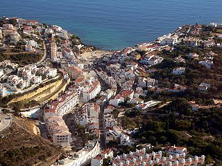
Carvoeiro is a town and a former civil parish in the municipality (concelho) of Lagoa, Algarve, Portugal. In 2013, the parish merged into the new parish Lagoa e Carvoeiro. The population in 2011 was 2,721, in an area of 11.66 km². It is located about 5 kilometres (3.1 mi) south of Lagoa.

<span class="mw-page-title-main">Odemira</span> Municipality in Alentejo, Portugal

Odemira is a town and a municipality in Beja District in the Portuguese region of Alentejo. The population in 2011 was 26,066, in an area of 1720.60 km2, making it the largest municipality of Portugal by area.

<span class="mw-page-title-main">Sines</span> Municipality in Alentejo, Portugal

Sines is a town and a municipality in Portugal. The municipality, divided into two parishes, has around 14,214 inhabitants (2021) in an area of 203.30 km2 (78.49 sq mi). Sines holds an important oil refinery and several petrochemical industries. It is also a popular beach spot and the main fishing harbour of Alentejo region.

<span class="mw-page-title-main">Vila Nova de Milfontes</span> Civil parish in Alentejo, Portugal

Vila Nova de Milfontes is a town and civil parish (freguesia) in the municipality (concelho) of Odemira, in the Alentejo region in Portugal. The population in 2021 was 5,653, in an area of 76.48 km2.

<span class="mw-page-title-main">Vila do Porto (parish)</span> Civil parish in Azores, Portugal

Vila do Porto is a civil parish in the municipality of Vila do Porto, located on the island of Santa Maria, in the Portuguese autonomous region of Azores. It is the southernmost and easternmost parish in the archipelago of Azores. The population in 2011 was 3,119, in an area of 25.55 km².

<span class="mw-page-title-main">Fortress of São João Baptista (Angra do Heroísmo)</span>

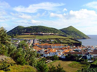
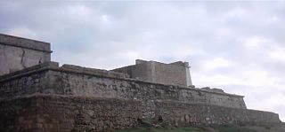
The Fortress of São João Baptista, also known as the Fort of São Filipe or Fort of Monte Brasil is a historic fortress and defensive emplacement, located in the civil parish of Sé, municipality of Angra do Heroísmo in the Portuguese island of Terceira, archipelago of the Azores.

<span class="mw-page-title-main">Porto Covo</span> Civil parish in Alentejo, Portugal

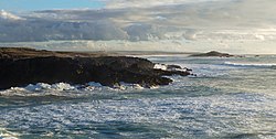
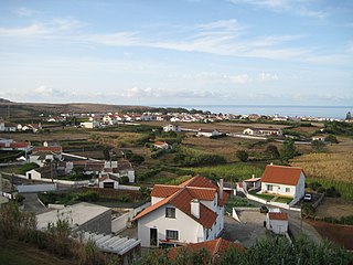
Porto Covo is one of the two civil parishes in the municipality of Sines, located along the western Alentejo coast of Portugal, about 170 km (110 mi) south of Lisbon. The population in 2011 was 1,038, in an area of 50.72 km2. Known for its beaches and ties to the ocean, the name Porto Covo likely translates as port of the covos, the term covo referring to a fishing net, used for capturing lobsters and crabs.

<span class="mw-page-title-main">Fort of São Sebastião de Caparica</span> Fort in Portugal

The Fort of São Sebastião de Caparica also known as the Tower of São Sebastião or Fortress of the Old Tower is a medieval fortification located in Monte da Caparica, civil parish of Caparica, in the municipality of Almada, in the Portuguese central region of Península de Setúbal.

<span class="mw-page-title-main">Fort of São João do Arade</span>

The Fort of São João do Arade, sometimes referred to as the Castle of Arade, is a medieval fortification situated in the civil parish of Ferragudo in the Portuguese Algarve municipality of Lagoa.

<span class="mw-page-title-main">Fort of Nossa Senhora da Rocha (Porches)</span> Fort in Porches, Lagoa, Portugal

The Fort of Nossa Senhora da Rocha is a medieval castle situated in the civil parish of Porches, in the municipality of Lagoa in Portuguese Algarve. Inside the fort is the Chapel of Nossa Senhora da Rocha, of uncertain date.

The Três Paus redoubt is a redoubt fortification situated on the peninsula of Monte Brasil, in the civil parish of Sé, in the municipality of Angra do Heroísmo, in the Portuguese archipelago of the Azores. Part of the fortified defenses of the Fortress of São João Baptista, it was also known as the Fort/Redoubt of Benedict the Moor.

<span class="mw-page-title-main">Fort of Santa Cruz (Horta)</span>

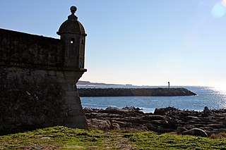
Fort of Santa Cruz, is a 16th-century fortification located in the civil parish of Angústias, municipality of Horta, on the island of Faial in the Portuguese Azores. Occasionally referred to as the Castelo de Santa Cruz by locals, it is situated in the historic centre of the city, on the edge of Horta Bay. It was constructed to work in conjunction with the Fort of Bom Jesus at the mouth of the Ribeira da Conceição and Fort of Greta along the coast of the extinct spatter cone Monte da Guia, to defend the entrance to the harbour and southern access to the Bay.

<span class="mw-page-title-main">Fort of São João Baptista (Berlengas)</span>

The Fort of São João Baptista das Berlengas, or simply known as the Fort of the Berlengas, is located off western coast of Portugal, on the largest island of the archipelago of the Berlengas, in the municipality of Peniche in Oeste region. The fortification belonged to a group of defensive military structures meant to protect the municipality located on the coast.

<span class="mw-page-title-main">Fort of Lagarteira</span>

The Fort of Lagarteira is a medieval fort in the civil parish of Vila Praia de Âncora, municipality of Caminha in the Portuguese Norte, classified as a Property of Public Interest.

<span class="mw-page-title-main">Church of Porto Covo</span> Church in Alentejo, Portugal

The Church of Porto Covo is Baroque and Neoclassic church in the civil parish, municipality of Sines, in the Atlantic coast of the Portuguese Alentejo. The church's austere lines is a morphological hybridization of the styles employed during the reign of Queen Maria I. In the widespread typology of regional architecture, the Baroque elements are evident in the lintels and trim curves, framed in a composition that is, generally, more rigid then in the gable design.

<span class="mw-page-title-main">Lighthouse of São Miguel-o-Anjo</span> Lighthouse

The Lighthouse of São Miguel-o-Anjo is a former hermitage and 16th century lighthouse, in the civil parish of Aldoar, Foz do Douro e Nevogilde, municipality of Porto, in the Portuguese Norte Region. The lighthouse of São Miguel-o-Anjo is Portugal's oldest existing lighthouse and one of the oldest in Europe. Designed by Italian architect Francesco da Cremona, the project was completed in 1538.

<span class="mw-page-title-main">Fort Nossa Senhora da Queimada</span>

The Fort Nossa Senhora da Queimada also knows as Fort of Pessegueiro is a fort situated along the coast of the civil parish of Porto Covo, municipality of Sines, in the southern Alentejo of Portugal, across from the island of the same name.

<span class="mw-page-title-main">Fort Nossa Senhora da Luz (Lagos)</span>

The Fort Nossa Senhora da Luz, also known locally as Castle of Senhora da Luz is a fort in the civil parish of Luz, municipality of Lagos in the Portuguese Algarve, classified as a Property of Public Interest.

References

Notes
  1. Sailing Directions (Enroute), Pub. 143: West Coast of Europe and Northwest Africa (PDF). Sailing Directions . United States National Geospatial-Intelligence Agency. 2017. p. 163.
  2. "Ilha do Pessegueiro" (in Portuguese). Sines, Portugal: Câmara Municipal de Sines. 2011. Archived from the original on 27 January 2012. Retrieved 14 January 2012.
  3. 1 2 3 4 5 6 7 8 9 10 11 Mendonça, Isabel; Matias, Cecília (2011). SIPA (ed.). "Forte na Ilha do Pessegueiro" (in Portuguese). Lisbon, Portugal: SIPA – Sistema de Informação para o Património Arquitectónico. Retrieved 14 January 2012.
  4. 1 2 3 4 IGESPAR, ed. (2011). "Forte do Pessegueiro, incluindo a ilha do mesmo nome, abrangendo o Forte da Ilha de Dentro" (in Portuguese). Lisbon, Portugal: IGESPAR-Instituto de Gestão do Património Arquitectónico e Arqueológico. Retrieved 16 January 2012.

Sources