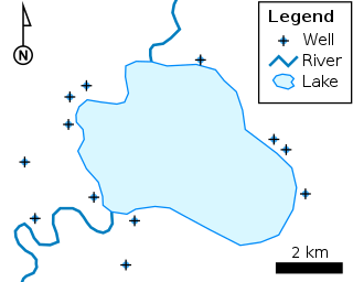
A geographic information system (GIS) consists of integrated computer hardware and software that store, manage, analyze, edit, output, and visualize geographic data. Much of this often happens within a spatial database; however, this is not essential to meet the definition of a GIS. In a broader sense, one may consider such a system also to include human users and support staff, procedures and workflows, the body of knowledge of relevant concepts and methods, and institutional organizations.

PostGIS is an open source software program that adds support for geographic objects to the PostgreSQL object-relational database. PostGIS follows the Simple Features for SQL specification from the Open Geospatial Consortium (OGC).

The Geography Markup Language (GML) is the XML grammar defined by the Open Geospatial Consortium (OGC) to express geographical features. GML serves as a modeling language for geographic systems as well as an open interchange format for geographic transactions on the Internet. Key to GML's utility is its ability to integrate all forms of geographic information, including not only conventional "vector" or discrete objects, but coverages and sensor data.
A coverage is the digital representation of some spatio-temporal phenomenon. ISO 19123 provides the definition:
A GIS file format is a standard for encoding geographical information into a computer file, as a specialized type of file format for use in geographic information systems (GIS) and other geospatial applications. Since the 1970s, dozens of formats have been created based on various data models for various purposes. They have been created by government mapping agencies, GIS software vendors, standards bodies such as the Open Geospatial Consortium, informal user communities, and even individual developers.

TerraLib is an open-source geographic information system (GIS) software library. It extends object-relational database management systems (DBMS) to handle spatiotemporal data types.
In computer programming contexts, a data cube is a multi-dimensional ("n-D") array of values. Typically, the term data cube is applied in contexts where these arrays are massively larger than the hosting computer's main memory; examples include multi-terabyte/petabyte data warehouses and time series of image data.

MonetDB is an open-source column-oriented relational database management system (RDBMS) originally developed at the Centrum Wiskunde & Informatica (CWI) in the Netherlands. It is designed to provide high performance on complex queries against large databases, such as combining tables with hundreds of columns and millions of rows. MonetDB has been applied in high-performance applications for online analytical processing, data mining, geographic information system (GIS), Resource Description Framework (RDF), text retrieval and sequence alignment processing.
A GIS software program is a computer program to support the use of a geographic information system, providing the ability to create, store, manage, query, analyze, and visualize geographic data, that is, data representing phenomena for which location is important. The GIS software industry encompasses a broad range of commercial and open-source products that provide some or all of these capabilities within various information technology architectures.
ArcSDE is a server-software sub-system that aims to enable the usage of Relational Database Management Systems for spatial data. The spatial data may then be used as part of a geodatabase.
A spatial database is a general-purpose database that has been enhanced to include spatial data that represents objects defined in a geometric space, along with tools for querying and analyzing such data.
Oracle Spatial and Graph, formerly Oracle Spatial, is a free option component of the Oracle Database. The spatial features in Oracle Spatial and Graph aid users in managing geographic and location-data in a native type within an Oracle database, potentially supporting a wide range of applications — from automated mapping, facilities management, and geographic information systems (AM/FM/GIS), to wireless location services and location-enabled e-business. The graph features in Oracle Spatial and Graph include Oracle Network Data Model (NDM) graphs used in traditional network applications in major transportation, telcos, utilities and energy organizations and RDF semantic graphs used in social networks and social interactions and in linking disparate data sets to address requirements from the research, health sciences, finance, media and intelligence communities.
Digital Earth is the name given to a concept by former US vice president Al Gore in 1998, describing a virtual representation of the Earth that is georeferenced and connected to the world's digital knowledge archives.
A geographic data model, geospatial data model, or simply data model in the context of geographic information systems, is a mathematical and digital structure for representing phenomena over the Earth. Generally, such data models represent various aspects of these phenomena by means of geographic data, including spatial locations, attributes, change over time, and identity. For example, the vector data model represents geography as collections of points, lines, and polygons, and the raster data model represent geography as cell matrices that store numeric values. Data models are implemented throughout the GIS ecosystem, including the software tools for data management and spatial analysis, data stored in a variety of GIS file formats, specifications and standards, and specific designs for GIS installations.
Hans-Peter Kriegel is a German computer scientist and professor at the Ludwig Maximilian University of Munich and leading the Database Systems Group in the Department of Computer Science. He was previously professor at the University of Würzburg and the University of Bremen after habilitation at the Technical University of Dortmund and doctorate from Karlsruhe Institute of Technology.

The Open Geospatial Consortium (OGC) is an international voluntary consensus standards organization that develops and maintains international standards for geospatial content and location-based services, sensor web, Internet of Things, GIS data processing and data sharing. The OGC was incorporated as a not for profit in 1994. At that time, the official name was the OpenGIS Consortium. Currently, commercial, government, nonprofit, universities, and research organizations participate in a consensus process encouraging development, maintenance, and implementation of open standards.

rasdaman is an Array DBMS, that is: a Database Management System which adds capabilities for storage and retrieval of massive multi-dimensional arrays, such as sensor, image, simulation, and statistics data. A frequently used synonym to arrays is raster data, such as in 2-D raster graphics; this actually has motivated the name rasdaman. However, rasdaman has no limitation in the number of dimensions - it can serve, for example, 1-D measurement data, 2-D satellite imagery, 3-D x/y/t image time series and x/y/z exploration data, 4-D ocean and climate data, and even beyond spatio-temporal dimensions.

An array database management system or array DBMS provides database services specifically for arrays, that is: homogeneous collections of data items, sitting on a regular grid of one, two, or more dimensions. Often arrays are used to represent sensor, simulation, image, or statistics data. Such arrays tend to be Big Data, with single objects frequently ranging into Terabyte and soon Petabyte sizes; for example, today's earth and space observation archives typically grow by Terabytes a day. Array databases aim at offering flexible, scalable storage and retrieval on this information category.
The Web Coverage Processing Service (WCPS) defines a language for filtering and processing of multi-dimensional raster coverages, such as sensor, simulation, image, and statistics data. The Web Coverage Processing Service is maintained by the Open Geospatial Consortium (OGC). This raster query language allows clients to obtain original coverage data, or derived information, in a platform-neutral manner over the Web.
GeoPackage (GPKG) is an open, non-proprietary, platform-independent and standards-based data format for geographic information systems built as a set of conventions over a SQLite database. Defined by the Open Geospatial Consortium (OGC) with the backing of the US military and published in 2014, GeoPackage has seen widespread support from various government, commercial, and open source organizations.


