Petroleum geology is the study of the origins, occurrence, movement, accumulation, and exploration of hydrocarbon fuels. It refers to the specific set of geological disciplines that are applied to the search for hydrocarbons.

A salt dome is a type of structural dome formed when salt intrudes into overlying rocks in a process known as diapirism. Salt domes can have unique surface and subsurface structures, and they can be discovered using techniques such as seismic reflection. They are important in petroleum geology as they can function as petroleum traps.

The Los Angeles Basin is a sedimentary basin located in Southern California, in a region known as the Peninsular Ranges. The basin is also connected to an anomalous group of east–west trending chains of mountains collectively known as the Transverse Ranges. The present basin is a coastal lowland area, whose floor is marked by elongate low ridges and groups of hills that is located on the edge of the Pacific plate. The Los Angeles Basin, along with the Santa Barbara Channel, the Ventura Basin, the San Fernando Valley, and the San Gabriel Basin, lies within the greater Southern California region. The majority of the jurisdictional land area of the city of Los Angeles physically lies within this basin.

In structural geology, a fold is a stack of originally planar surfaces, such as sedimentary strata, that are bent or curved ("folded") during permanent deformation. Folds in rocks vary in size from microscopic crinkles to mountain-sized folds. They occur as single isolated folds or in periodic sets. Synsedimentary folds are those formed during sedimentary deposition.

In structural geology, an anticline is a type of fold that is an arch-like shape and has its oldest beds at its core, whereas a syncline is the inverse of an anticline. A typical anticline is convex up in which the hinge or crest is the location where the curvature is greatest, and the limbs are the sides of the fold that dip away from the hinge. Anticlines can be recognized and differentiated from antiforms by a sequence of rock layers that become progressively older toward the center of the fold. Therefore, if age relationships between various rock strata are unknown, the term antiform should be used.

A diapir is a type of intrusion in which a more mobile and ductilely deformable material is forced into brittle overlying rocks. Depending on the tectonic environment, diapirs can range from idealized mushroom-shaped Rayleigh–Taylor instability structures in regions with low tectonic stress such as in the Gulf of Mexico to narrow dikes of material that move along tectonically induced fractures in surrounding rock.
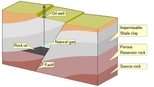
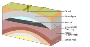
A petroleum reservoir or oil and gas reservoir is a subsurface accumulation of hydrocarbons contained in porous or fractured rock formations. Such reservoirs form when kerogen is created in surrounding rock by the presence of high heat and pressure in the Earth's crust.
A petroleum geologist is an earth scientist who works in the field of petroleum geology, which involves all aspects of oil discovery and production. Petroleum geologists are usually linked to the actual discovery of oil and the identification of possible oil deposits, gas caps, or leads. It can be a very labor-intensive task involving several different fields of science and elaborate equipment. Petroleum geologists look at the structural and sedimentary aspects of the stratum/strata to identify possible oil traps or tight shale plays.

Salt tectonics, or halokinesis, or halotectonics, is concerned with the geometries and processes associated with the presence of significant thicknesses of evaporites containing rock salt within a stratigraphic sequence of rocks. This is due both to the low density of salt, which does not increase with burial, and its low strength.
The Queen Charlotte Basin is a structural basin mostly beneath the continental shelf offshore, between Haida Gwaii, Vancouver Island, and the British Columbia mainland, roughly coincident with the physiographic region named the Hecate Depression.
Caprock or cap rock is a more resistant rock type overlying a less resistant rock type, analogous to an upper crust on a cake that is harder than the underlying layer.

The Jeanne d'Arc Basin is an offshore sedimentary basin located about 340 kilometres to the basin centre, east-southeast of St. John's, Newfoundland and Labrador. This basin formed in response to the large scale plate tectonic forces that ripped apart the super-continent Pangea and also led to sea-floor spreading in the North Atlantic Ocean. This basin is one of a series of rift basins that are located on the broad, shallow promontory of continental crust known as the Grand Banks of Newfoundland off Canada's east coast. The basin was named after a purported 20 metres shoal labelled as "Ste. Jeanne d'Arc" on out-dated bathymetric charts and which was once thought to represent a local exposure of basement rocks similar to the Virgin Rocks.
The salt tectonics off the Louisiana gulf coast can be explained through two possible methods. The first method attributes spreading of the salt because of sedimentary loading while the second method points to slope instability as the primary cause of gliding of the salt. The first method results in the formation of growth faults in the overlying sediment. Growth faults are normal faults that occur simultaneously with sedimentation, causing them to have thicker sediment layers on the downthrown sides of the faults. In the second method both the salt and the sediment are moving, making it more likely to migrate.

Growth faults are syndepositional or syn-sedimentary extensional faults that initiate and evolve at the margins of continental plates. They extend parallel to passive margins that have high sediment supply. Their fault plane dips mostly toward the basin and has long-term continuous displacement. Figure one shows a growth fault with a concave upward fault plane that has high updip angle and flattened at its base into zone of detachment or décollement. This angle is continuously changing from nearly vertical in the updip area to nearly horizontal in the downdip area.

The Columbus Basin is a foreland basin located off the south eastern coast of Trinidad within the East Venezuela Basin (EVB). Due to the intensive deformation occurring along the Caribbean and South American plates in this region, the basin has a unique structural and stratigraphic relationship. The Columbus Basin has been a prime area for hydrocarbon exploration and production as its structures, sediments and burial history provide ideal conditions for generation and storage of hydrocarbon reserves. The Columbus Basin serves as a depocenter for the Orinoco River delta, where it is infilled with 15 km of fluvio-deltaic sediment. The area has also been extensively deformed by series of north west to southeast normal faults and northeast to southwest trending anticline structures.
The Halibut Field is an oil field, within the Gippsland Basin offshore of the Australian state of Victoria. The oil field is located approximately 64 km offshore of southeastern Australia. The total area of this field is 26.9 km2 and is composed of 10 mappable units.

The Delta Field is located offshore from Nigeria on Oil Mining Leases (OML) 49 and 95. This is located within the Niger Delta Basin and sits in 12 feet of water. In 1965, the Delta 1 well was completed and the Delta Field opened in 1968 for production.

The Bolivar Coastal Fields (BCF), also known as the Bolivar Coastal Complex, is located on the eastern margin of Lake Maracaibo, Venezuela. Bolivar Coastal Field is the largest oil field in South America with its 6,000-7,000 wells and forest of related derricks, stretches thirty-five miles along the north-east coast of Lake Maracaibo. They form the largest oil field outside of the Middle East and contain mostly heavy oil with a gravity less than 22 degrees API. Also known as the Eastern Coast Fields, Bolivar Coastal Oil Field consists of Tía Juana, Lagunillas, Bachaquero, Ceuta, Motatán, Barua and Ambrosio. The Bolivar Coast field lies in the Maracaibo dry forests ecoregion, which has been severely damaged by farming and ranching as well as oil exploitation. The oil field still plays an important role in production from the nation with approximately 2.6 million barrels of oil a day. It is important to note that the oil and gas industry refers to the Bolivar Coastal Complex as a single oilfield, in spite of the fact that the oilfield consists of many sub-fields as stated above.
The Officer Basin is an intracratonic sedimentary basin that covers roughly 320,000 km2 along the border between southern and western Australia. Exploration for hydrocarbons in this basin has been sparse, but the geology has been examined for its potential as a hydrocarbon reservoir. This basin's extensive depositional history, with sedimentary thicknesses exceeding 6 km and spanning roughly 350 Ma during the Neoproterozoic, make it an ideal candidate for hydrocarbon production.

The Arkoma Basin is a peripheral foreland basin that extends from central west Arkansas to south eastern Oklahoma. The basin lies in between the Ozark Uplift and Oklahoma Platform to the north and Ouachita Mountains to the south and with an area of approximately 33,800 mi2. Along the southern edge of the basin, the Choctaw Fault is the boundary that separates the mountains from the basin itself. This basin is one of seven that lie along the front of the Ouachita and Appalachian mountain systems. This basin is Oklahoma's fourth largest in terms of natural gas production. Oil has been extracted locally, but not on a commercial scale. Coal was the first natural resource used commercially within the basin. Surface mapping of coal seams in the early part of the 20th century lead to the discovery of sub-surface features that indicated the presence of natural gas. Mansfield, Arkansas was the site of the first natural gas discovery in 1902.