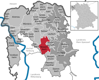
Aschaffenburg is a Landkreis (district) in Bavaria, Germany. It is bounded by the districts of Darmstadt-Dieburg, Offenbach, Main-Kinzig, the districts Main-Spessart and Miltenberg, and the town of Aschaffenburg.

Penobscot Knob, also Penobscot Mountain, is a summit located in the western fringe of the Poconos nearest to Mountain Top, Pennsylvania which in the Solomon Gap pass below it lies an important multi-modal transportation corridor. At one time before incorporation, Mountain Top and the saddle of the pass was known by the Amerindian name Penobscot. Penobscot Mountain forms part of the drainage divide between the Lehigh Valley & greater Delaware River drainage basin and the Wyoming and Susquehanna Valley, part of the Potomac River drainage basin. The pass formed between Penobscot and Haystack Mountain a few thousand feet to the West was one of the few places a railroad could be envisioned in the 1830s when the fuel crises in eastern cities demanded easier transportation to the Northern Anthracite Coal Fields, which ironically, came to be exploited by the company with a near monopoly in providing coal from the Southern Anthracite region, Lehigh Coal & Navigation Company, which had built both the Lehigh Canal, but also the nation's second railway, the Summit Hill & Mauch Chunk Railroad. The whole uplands north and west faces over look the Wyoming Valley from the southeastern corner near Hazleton towards and through the greater south Wilkes-Barre area. The southern and eastern slopes just give peeks into portions of the Poconos and wider views of the Lehigh Valley descending down to White Haven, for the Poconos technically are left-bank bounded by the Lehigh.
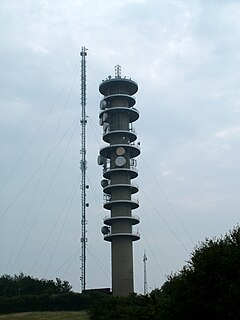
The Peterborough transmitting station is a broadcasting and telecommunications facility at Morborne Hill, near Peterborough,.

The Lichfield transmitting station is situated close to Tamworth in Staffordshire in the West Midlands between the A5 and A51. The nearest geographical feature is Hopwas Hill. The station is owned and operated by Arqiva. The mast is known locally as Hopwas mast or Hints mast.
Camp Fortune is a commercial alpine ski centre located in the municipality of Chelsea in the Gatineau Hills north of Gatineau, Quebec, approximately fifteen minutes from Downtown Ottawa, Ontario.

Amol County is a county in Mazandaran Province in Iran. The capital of the county is Amol. At the 2006 census, the county's population was 343,747, in 93,194 families. The county is subdivided into three districts: the Central District, Larijan District, and Dabudasht District. The county has five cities: Amol, Rineh, Gazanak, Dabudasht & Amamzadeh Abdallah.

The Cleveland Hills are a range of hills on the north-west edge of the North York Moors in North Yorkshire, England, overlooking Cleveland and Teesside. They lie entirely within the boundaries of the North York Moors National Park. Part of the 110-mile (177 km) long Cleveland Way National Trail runs along the hills, and they are also crossed by a section of Wainwright's Coast to Coast Walk. The hills, which rise abruptly from the flat Tees Valley to the north, include distinctive landmarks such as the cone-shaped peak of Roseberry Topping, near the village of Great Ayton – childhood home of Captain James Cook.

Mespelbrunn is a community in the Aschaffenburg district in the Regierungsbezirk of Lower Franconia (Unterfranken) in Bavaria, Germany and a member of the Verwaltungsgemeinschaft of Mespelbrunn, whose seat is in Heimbuchenthal.

Leidersbach is a community in the Miltenberg district in the Regierungsbezirk of Lower Franconia (Unterfranken) in Bavaria, Germany.
KMJ is a news/talk radio station located in Fresno, California, owned by Cumulus Media. Its studios are located at the Radio City building on Shaw Avenue in North Fresno and its transmitter is in Orange Cove, California. While 580 kHz is a Regional broadcast frequency, the station broadcasts with 50,000 watts, the highest power for an AM station permitted by the FCC, covering most of Central California.

The Hohe Möhr is a mountain, 983.6 m above sea level (NHN), in the Black Forest near Schopfheim in the German state of Baden-Württemberg.

Hohe Wart is a wooded hill of the Spessart range in Bavaria, Germany. It is located in the unincorporated area Forst Hohe Wart, between the districts of Aschaffenburg and Miltenberg.
Hohe Warte (Spessart) is a wooded hill of Bavaria, Germany. It has an elevation of up to 572 meters above NHN and lies in the Spessart range.
The Hohe Warte is a largely forested upland with four striking hills on the southwestern fringe of the Fichtelgebirge mountains located in northern Bavaria, near Bayreuth. Its highest peak is the Hirschberg. About 60% of the ridge lies on the territory of the parish of Bindlach, the other 40% is divided between the town of Bayreuth and the parish of Heinersreuth. A number of lakes and streams have their origin in these hills and are an important source of drinking water for the surrounding settlements.

Papoose Peak Jumps was a ski jumping hill located at Squaw Valley Ski Resort in the US state of California. The hill consisted of three jumps, with K-points of 80, 60 and 40 meters, respectively. Constructed upon the hill-side of Little Papoose Peak, it was built for the 1960 Winter Olympics; the 80-meter hill hosted the ski jumping event and the 60-meter hill the Nordic combined event. The jump was designed by Heini Klopfer and opened in 1958. After the Olympics the venue saw little use; it was renovated for the 1976 US National Ski Jumping Championships, but has since fallen into disrepair and demolished to make room for a ski lift.

The Hohe Derst is a hill, 561 metres above sea level, in the Palatine Forest of southwest Germany. It lies within the Wasgau region and is the highest point of the Mundat Forest.
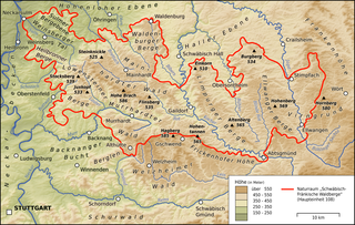
The Limpurg Hills are a hill range, up to 564.7 m above sea level (NHN), in the Swabian-Franconian Forest in the counties of Schwäbisch Hall and Ostalbkreis in the German state of Baden-Württemberg. The majority of the region belonged formerly to Limpurg Land owned by the family of Schenken von Limpurg, whose name was derived from their family home, Limpurg Castle near Schwäbisch Hall.