
Cripple Creek is a statutory city that is the county seat of Teller County, Colorado, United States. The city population was 1,155 at the 2020 United States Census. Cripple Creek is a former gold mining camp located 20 miles (32 km) southwest of Colorado Springs near the base of Pikes Peak. The Cripple Creek Historic District, which received National Historic Landmark status in 1961, includes part or all of the city and the surrounding area. The city is now a part of the Colorado Springs, CO Metropolitan Statistical Area and the Front Range Urban Corridor.

Mohave County is a county in the northwestern corner of the U.S. state of Arizona. As of the 2020 census, its population was 213,267. The county seat is Kingman, and the largest city is Lake Havasu City. It is the fifth largest county in the United States.

Cañon City is a home rule municipality that is the county seat and the most populous municipality of Fremont County, Colorado, United States. The city population was 17,141 at the 2020 United States Census. Cañon City is the principal city of the Cañon City, CO Micropolitan Statistical Area and is a part of the Front Range Urban Corridor. Cañon City straddles the easterly flowing Arkansas River and is a popular tourist destination for sightseeing, whitewater rafting, and rock climbing. The city is known for its many public parks, fossil discoveries, Skyline Drive, The Royal Gorge railroad, the Royal Gorge, and extensive natural hiking paths. In 1994, the United States Board on Geographic Names approved adding the tilde to the official name of Cañon City, a change from Canon City as the official name in its decisions of 1906 and 1975. It is one of the few U.S. cities to have the Spanish Ñ in its name, others being La Cañada Flintridge, California; Española, New Mexico; Peñasco, New Mexico; and Peñitas, Texas.
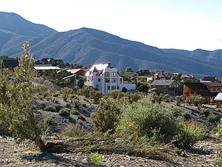
The City of Victor is a Statutory City in Teller County, Colorado, United States. Gold was discovered in Victor in the late 19th century, an omen of the future of the town. With Cripple Creek, the mining district became the second largest gold mining district in the country and realized approximately $10 billion of mined gold in 2010 dollars. It reached its peak around the turn of the century when there were about 18,000 residents in the town. Depleted ore in mines, labor strife and the exodus of miners during World War I caused a steep decline in the city's economy, from which it has never recovered. The population was 379 at the 2020 census. There is a resumed mining effort on Battle Mountain.

The Mojave River is an intermittent river in the eastern San Bernardino Mountains and the Mojave Desert in San Bernardino County, California, United States. Most of its flow is underground, while its surface channels remain dry most of the time, except for the headwaters and several bedrock gorges in the lower reaches.

The Black Rock Desert is a semi-arid region of lava beds and playa, or alkali flats, situated in the Black Rock Desert–High Rock Canyon Emigrant Trails National Conservation Area, a silt playa 100 miles (160 km) north of Reno, Nevada, that encompasses more than 300,000 acres (120,000 ha) of land and contains more than 120 miles (200 km) of historic trails. It is in the northern Nevada section of the Great Basin with a lakebed that is a dry remnant of Pleistocene Lake Lahontan.
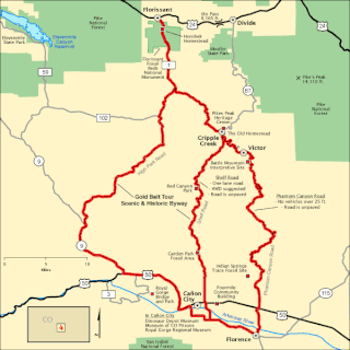
The Gold Belt Tour Scenic and Historic Byway is a National Scenic Byway, a Back Country Byway, and a Colorado Scenic and Historic Byway located in Fremont and Teller counties, Colorado, USA. The byway is named for the Gold Belt mining region. The Cripple Creek Historic District is a National Historic Landmark. The byway forms a three-legged loop with the Phantom Canyon Road, the Shelf Road, and the High Park Road (paved).

The Midland Terminal Railway was a short line terminal railroad running from the Colorado Midland Railway near Divide to Cripple Creek, Colorado. The railroad made its last run in February 1949.

Cascade is an unincorporated community and U.S. Post Office in El Paso County, Colorado, United States. The ZIP Code of the Cascade Post Office is 80809.

Aravaipa Canyon Wilderness is a 19,410 acres (7,850 ha) wilderness area located in the U.S. State of Arizona.
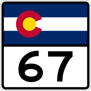
State Highway 67 (SH 67) is a 71-mile-long (114 km) state highway encompassing five distinct segments in south-central Colorado. SH 67's southern terminus is at SH 96 in Wetmore, and the northern terminus is at U.S. Route 85 in Sedalia. It traverses the former route of the Florence and Cripple Creek Railroad through Phantom Canyon as a county road and carrying part of the Gold Belt Byway.

Before it was founded, the site of modern-day Colorado Springs, Colorado, was part of the American frontier. Old Colorado City, built in 1859 during the Pike's Peak Gold Rush was the Colorado Territory capital. The town of Colorado Springs was founded by General William Jackson Palmer as a resort town. Old Colorado City was annexed into Colorado Springs. Railroads brought tourists and visitors to the area from other parts of the United States and abroad. The city was noted for junctions for seven railways: Denver and Rio Grande (1870), Denver and New Orleans Manitou Branch (1882), Colorado Midland (1886–1918), Colorado Springs and Interurban, Atchison, Topeka, and Santa Fe (1889), Rock Island (1889), and Colorado Springs and Cripple Creek Railways. It was also known for mining exchanges and brokers for the Cripple Creek Gold Rush.

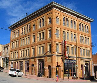
Cripple Creek Historic District is a historic district including Cripple Creek, Colorado, United States and is significant for its gold mining era history. It developed as a gold mining center beginning in 1890, with a number of buildings from that period surviving to this day. The mines in the area were among the most successful, producing millions of dollars of gold in the 1890s and supporting a population of 25,000 at its peak. It was declared a National Historic Landmark in 1961.

Areas of Critical Environmental Concern (ACEC) is a conservation ecology program in the Western United States, managed by the Bureau of Land Management (BLM). The ACEC program was conceived in the 1976 Federal Lands Policy and Management Act (FLPMA), which established the first conservation ecology mandate for the BLM. The FLPMA mandate directs the BLM to protect important riparian corridors, threatened and endangered species habitats, cultural and archeological resources, as well as unique scenic landscapes that the agency assesses as in need of special management attention.

The Florence and Cripple Creek Railroad (F&CC) was a 3 ft narrow-gauge railroad running northward from junctions with the Denver & Rio Grande Railroad at the mill towns of Florence and later moved to Cañon City, Colorado, on the banks of the Arkansas River, up steep and narrow Phantom Canyon to the Cripple Creek Mining District, west of Pikes Peak. It was founded in 1893 and went out of business in 1915.
Adelaide is an extinct town located in Fremont County, Colorado, United States. The townsite is located at 38.5600°N 105.0908°W at an elevation of 6,949 feet (2,118 m). Previously known as Robinson, the former mining camp and railroad water is located along the Phantom Canyon Road. The Adelaide Bridge is located just north of the townsite.

Cheyenne Mountain is a triple-peaked mountain in El Paso County, Colorado, southwest of downtown Colorado Springs. The mountain serves as a host for military, communications, recreational, and residential functions. The underground operations center for the North American Aerospace Defense Command (NORAD) was built during the Cold War to monitor North American airspace for missile launches and Soviet military aircraft. Built deep within granite, it was designed to withstand the impact and fallout from a nuclear bomb. Its function broadened with the end of the Cold War, and then many of its functions were transferred to Peterson Air Force Base in 2006.

Grape Creek is a tributary of the Arkansas River that flows through Custer and Fremont counties in South-Central Colorado. The creek drains much of the Wet Mountain Valley, located between the Sangre de Cristo Mountains and the Wet Mountains in Custer County.
Cold Creek is an unincorporated community in Clark County, Nevada, United States located within the Spring Mountains National Recreation Area and approximately 28 miles by road from the Las Vegas city limits. Cold Creek is named for the stream that flows through the community.
